- All Categories (15)
- News (6)
- Missions (1)
- Events (7)
- Activities (1)
News - Success Stories
Synergy of space data helps modernise irrigation systems
The growing demands on agriculture, coupled with the climate crisis, are pressurising Earth’s valuable freshwater resources and making assessment of water practices ever more important.
News - Success Stories
Commercial space data help to regreen grasslands in Africa
Commercial satellite imagery made available through ESA’s Third Party Missions programme is guiding an ambitious community-focused initiative to regrow natural grasslands in Sub-Saharan Africa.
News - Events and Proceedings
GLOC 2023: Democratising data access key to climate action
The need for easy access to remote sensing data and making them more digestible to the local user community, were take home messages from the first Global Space Conference on Climate Change (GLOC), held in Oslo, Norway, last week.
News - Success Stories
Space data unearths small-scale mining in Burkina Faso
Satellite data from ESA’s Pléiades Third Party Mission and Copernicus Sentinel-2 were used to demonstrate that deep learning models can accurately and inexpensively identify artisanal and small-scale mining, even in challenging semi-desertic environments.
Event - Workshop

Space and the Arctic 2009 Workshop
Temperatures in the Arctic are rising at an unprecedented rate. This workshop looked at the needs and challenges of working and living in the rapidly changing Arctic and explore how space-based services might help to meet those needs.
Event - Workshop
Insurance Industry Workshop on Earth Observation
This ESA workshop examined the potential value of satellite Earth Observation data to the insurance industry.
News - Infographics

An overview of ESA's Third Party Missions programme
ESA’s Third Party Missions programme consists of almost 50 satellite missions, which are owned by organisations around the world. ESA has agreements with these organisations to acquire, process, and distribute data from their missions
News - Events and Proceedings

Φ-Week Triumphs
In its fourth edition, Φ-Week presented the scientific community with amazing opportunities and projects—thus running alongside innovation at 360 degrees.
Activity - General activities

EO Science for Society
ESA's Earth Observation Science for Society programme aims to promote scientific exploitation of satellite data, forges new scientific discoveries and pioneers new services, stimulating downstream industrial and economic growth.
Mission - Copernicus Sentinels
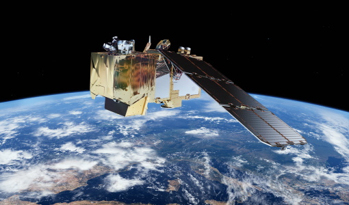
Copernicus Sentinel-2
The Copernicus Sentinel-2 mission comprises a constellation of two polar-orbiting satellites placed in the same sun-synchronous orbit, phased at 180° to each other.
Event - Workshop
CEOS-WGCV ACIX II CMIX Atmospheric Correction Inter-comparison Exercise Cloud Masking Inter-comparison Exercise 2nd workshop
The CEOS-WGCV ACIX II 2nd workshop took place at Esrin, Rome in Italy from 3 December - 5 December 2019.
Event - Training

Advanced Ocean Synergy Training Course
This ESA course was devoted to training the next generation of Earth Observation scientists to exploit data from ESA and Third Party Mission instruments for ocean science and application development.
Event - Meeting

3rd Sentinel-2 Validation Team Meeting
This Sentinel-2 Validation Team (S2VT) meeting was the third edition of a meeting series, initiated in 2016. The S2VT is organised under the auspices of ESA, CNES, and ENSEEIHT.
Event - Training
Advanced Training Course in Land Remote Sensing 2012
The 2012 advanced training course focused on land remote sensing theory and applications.
Event - Workshop
2nd MERIS/AATSR User Workshop
The workshop addressed the utilisation of MERIS and AATSR data for remote sensing of open oceans, coastal waters, land surfaces and atmospheric processes.