- All Categories (129)
- Data (24)
- News (58)
- Missions (6)
- Events (14)
- Tools (6)
- Activities (3)
- Campaigns (8)
- Documents (10)
News - Infographics

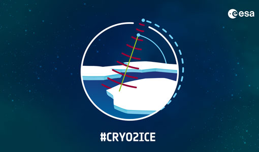
What is CRYO2ICE?
Learn about CRYO2ICE, an innovative campaign producing near simultaneous acquisitions over Antarctica from the CryoSat and ICESAT-2 missions, in this new infographic.
News - Data Release news

Updated CryoSat magnetometer data now available with new baseline 0201
An improved version of the CryoSat magnetic field data is now available on the Swarm Dissemination Server with new baseline 0201.
News - Data Release news

Updated CryoSat magnetometer data now available
An improved version of the CryoSat magnetic field data (version 0102) is now available in the "#CryoSat-2" folder of the ESA FTP server.
News - Infographics

The COSMO-SkyMed series - Two generations of SAR satellites
Learn about the COSMO-SkyMed (Constellation of small Satellites for the Mediterranean basin Observation) series in our latest infographic.
News - Data Release news

Systematic swath elevation and monthly DEMs over the Greenland Ice Sheet margin from CryoSat
The CryoTEMPO-EOLIS (Elevation Over Land Ice from Swath), the first of the CryoTEMPO products, is now available.
Activity - Projects

Swarm Outflow
The Swarm+ Coupling High-Low Atmosphere Interactions: Ion Outflow ("Swarm+ Outflow") project, which began in May 2019, centres on using Swarm spacecraft to tackle unanswered questions around non-thermal processes that lead to ion outflow.
News - General News
Stunning new features for ESA and NASA altimetry portal cs2eo.org
Working with combined ESA and NASA altimetry data is easier than ever thanks to a range of handy new features on cs2eo.org.
News - Thematic area articles

Space data help to unravel the complexities of Earth’s atmosphere
As the impacts of the climate crisis intensify, scientists are using ESA’s Earth observation archives to investigate atmospheric processes and their influences on the planet’s changing environment.
News - Operational News
SIRAL measurements continue during CRYO2ICE
On 16 July, ESA is kicking off its CRYO2ICE campaign that aims to raise CryoSat-2's orbit by approximately 900 metres, bringing it in sync with NASA's ICESat-2.
News - Events and Proceedings

Seventh CryoSat Quality Working Group meeting - final report
The 7th CryoSat Quality Working Group (QWG) meeting Summary and Recommendation Report are available to download.
Event - Workshop

SEASAR 2008
The "Advances in SAR Oceanography from Envisat and ERS missions" was a thematic workshop on SAR remote sensing techniques for oceanography.
Event - Workshop
SEASAR 2006
ESA organised it's first SAR oceanography workshop, SEASAR 2006, entitled "Advances in SAR Oceanography from Envisat and ERS missions"
News - Thematic area articles

Satellites reveal changes to Earth’s icy zones
ESA’s Earth observation activities are helping scientists investigate the influence of climate change on widespread ice-losses across the planet.
News - Success Stories

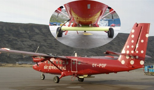
Robust airborne radar instrument aids CryoSat ice data
During the 12 years that ESA’s ice mission – CryoSat – has been monitoring Earth’s ice masses from space, simultaneous airborne measurements were made by ASIRAS.
News - Success Stories

Retrieving Snow Depth Over Sea Ice Using Dual-Frequency Altimetric Measurements
A new study from the sea ice team of the Laboratory of Space Geophysical and Oceanographic Studies (LEGOS) in Toulouse has shown that dual-frequency SARAL and CryoSat-2 altimetric measurements can be used to retrieve consistent snow depth data over sea ice in both hemispheres.
News - Data Release news

RADARSAT data on demand
In the framework of the Earthnet programme, ESA is distributing RADARSAT data on-demand to support EO science and research activities.
Event - Workshop
POLinSAR 2019
ESA organised POLinSAR 2019, the 9th International Workshop on Science and Applications of SAR Polarimetry and Polarimetric Interferometry.
Event - Workshop

POLinSAR 2013
The objectives of the PolInSAR 2013 workshop were to present the latest studies and results of SAR polarimetry and polarimetric interferometry.
Event - Workshop
POLinSAR 2009
The 2009 workshop focused on theory and methods in the fields of SAR Polarimetry and Polarimetric Interferometry
Data - Campaigns (Open)
POLARIS - Proof of Concept 2009
POLARIS - Proof of Concept (PoC) 2009 is a follow on campaign from POLARIS - PoC 2008. It focused on an additional POLARIS test with the objective to system test after system upgrade and the acquisition of fully polarimetric data of glaciological interest.