- All Categories (19)
- Data (3)
- News (10)
- Missions (1)
- Events (1)
- Activities (1)
- Campaigns (1)
- Documents (2)
News - Events and Proceedings
EarthCARE pre-launch science workshop a success
Held between 13 and 17 November 2023, in ESA’s Earth Observation facility in Frascati, Italy, the ESA-JAXA pre-launch EarthCARE science and validation workshop brought together nearly 250 participants, representing a vibrant worldwide scientific community that is eagerly awaiting the mission’s launch.
News - Spotlight on EO community
An overview of the EarthCARE mission
In this video, meet Björn Frommknecht, Mission Manager of ESA's upcoming EarthCARE satellite.
News - Spotlight on EO community
Introducing the EarthCARE Mission Manager
In this video, Björn Frommknecht describes his role as Mission Manager of EarthCARE, and what he enjoys most about his involvement with this upcoming Earth Explorer.
News - Events and Proceedings
Last call for EarthCARE workshop abstracts
The abstract submission deadline for the EarthCARE Pre-Launch Science and Validation Workshop is just a week away. If you would like to present your work at the workshop, submit your abstract by 10 July.
News - Events and Proceedings
Submit your abstracts for EarthCARE Pre-Launch Science and Validation Workshop
Invitations are now open for the EarthCARE Pre-Launch Science and Validation Workshop, which will take place at ESRIN in Frascati, Italy, from 13 to 17 November.
Event - Workshop
EarthCARE pre-launch science and validation workshop
The EarthCARE pre-launch Science and Validation Workshop will bring together the community to discuss the science of this upcoming cloud and aerosol mission, and offer the opportunity to discuss validation activities.
News - Infographics
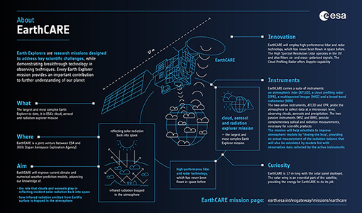
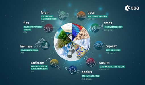
EarthCARE - ESA's cloud, aerosol and radiation explorer mission
Learn about ESA’s upcoming cloud, aerosol and radiation explorer mission – EarthCARE – in our latest infographic.
Activity - Projects
Dragon 3 Cooperation Programme
The Dragon 3 Programme focussed on the exploitation of ESA, ESA's Third Party Missions and Chinese Earth observation data for geo-science and applications development in land, ocean and atmospheric applications.
News - Events and Proceedings
Highlights from Living Planet Symposium
As remote sensing scientists and data-users from around the world converged at the Living Planet Symposium (LPS) in Bonn recently, a common thread was evident in many scientific sessions and meetings – the right environmental data can accelerate our understanding of the rapid changes in Earth’s system.
News - Thematic area articles
Space data help to unravel the complexities of Earth’s atmosphere
As the impacts of the climate crisis intensify, scientists are using ESA’s Earth observation archives to investigate atmospheric processes and their influences on the planet’s changing environment.
News - Thematic area articles
Satellite data central to ocean monitoring
Over 95% of Earth’s water is found in our oceans, and yet sadly, oceans are under stress from climate change and pollution. Monitoring our oceans is vital for Earth’s survival and satellites are the primary means of long-term and independent observation of our vast ocean bodies and their associated coastal zones.
Document - Algorithms Theoretical Baseline Document
EarthCARE-ATLID-L1-ATBO.pdf
This document provides the main processing steps required to generate EarthCARE ATLID Level 1B products and an overview of the algorithm. It is an Algorithm Theoretical Baseline Overview Document.
Document - Product Document
EarthCARE-ATLID-L1-Product-Definitions.pdf
Description of the format and content of the L1 Nominal products for the EarthCARE ATLID processor.
Data - Fast Registration with approval (Restrained)
TerraSAR-X ESA archive
The TerraSAR-X ESA archive collection consists of TerraSAR-X and TanDEM-X products requested by ESA supported projects over their areas of interest around the world. The dataset regularly grows as ESA collects new products over the years. TerraSAR-X/TanDEM-X Image Products can be acquired in 6 image modes with flexible resolutions (from 0.25m to 40m) and scene sizes. Thanks to different polarimetric combinations and processing levels the delivered imagery can be tailored specifically to meet the requirements of the application. The following list delineates the characteristics of the SAR imaging modes that are disseminated under ESA Third Party Missions (TPM). StripMap (SM): Resolution 3 m, Scene size 30x50 km2 (up to 30x1650 km2) SpotLight (SL): Resolution 2 m, Scene size 10x10 km2 Staring SpotLight (ST): Resolution 0.25m, Scene size 4x3.7 km2 High Resolution SpotLight (HS): Resolution 1 m, Scene size 10x5 km2 ScanSAR (SC): Resolution 18 m, Scene size 100x150 km2 (up to 100x1650 km2) Wide ScanSAR (WS): Resolution 40 m, Scene size 270x200 km2 (up to 270x1500 km2) The following list briefly delineates the available processing levels for the TerraSAR-X dataset: SSC (Single Look Slant Range Complex) in DLR-defined COSAR binary format MGD (Multi Look Ground Range Detected) in GeoTiff format • GEC (Geocoded Ellipsoid Corrected) in GeoTiff format EEC (Enhanced Ellipsoid Corrected in GeoTiff format Spatial coverage: Check the spatial coverage of the collection on a map available on the Third Party Missions Dissemination Service. As per ESA policy, very high-resolution data over conflict areas cannot be provided.
Data - Project Proposal (Restrained)
TerraSAR-X/TanDEM-X full archive and tasking
TerraSAR-X/TanDEM-X full archive and new tasking products can be acquired in six image modes with flexible resolutions (from 0.25 m to 40 m) and scene sizes and are provided in different packages: Staring SpotLight (basic, Interferometric pack, and Maritime pack) High Resolution SpotLight (basic, Interferometric pack, and Maritime pack) SpotLight (basic, Interferometric pack, and Maritime pack) StripMap (basic, Interferometric pack, and Maritime pack) ScanSAR (basic and Maritime pack) Wide ScanSAR (basic and Maritime pack) Product Overview Products SAR-ST SAR-HS SAR-SL SAR-SM SAR-SC SAR-WS Instrument mode Staring Spotlight High Resolution SpotLight SpotLight StripMap ScanSAR Wide ScanSAR Available resolutions (up to) 0.25 m 1 m 2 m 3 m 18 m 40 m Scene size 4x3.7 km2 10x5 km2 10x10 km2 30x50 km2 (up to 30x1650) 100x150 km2 (up to 100x1650) 270x200 km2 (up to 270x1500) Available processing levels SSC (Single Look Slant Range Complex): azimuth - slant range (time domain) MGD (Multi Look Ground Range Detected): azimuth - ground range (without terrain correction) GEC (Geocoded Ellipsoid Corrected): map geometry with ellipsoidal corrections only (no terrain correction performed) EEC (Enhanced Ellipsoid Corrected): map geometry with terrain correction, using a DEM Format SSC: DLR-defined COSAR binary MGD: GeoTiff GEC: GeoTiff EEC: GeoTiff Spatial coverage Worldwide Interferometry package InSAR-ST, InSAR-HS, InSAR-SL, InSAR-SM Only SSC At least five ordered scenes within six months from first order N/A N/A Maritime Monitoring package MmSAR-ST, MmSAR-HS, MmSAR-SL, MmSAR-SM, MmSAR-SC, MmSAR-WS Only SSC, MGD, GEC At least 75% of the scene area is water More than five ordered scenes in three months The following WorldDEM products can be requested: Products Description WorldDEMcore WorldDEMcore is output of interferometric processing of StripMap data pairs without any post-processing WorldDEMTM WorldDEMTM is produced based on WorldDEMcore, representing the surface of the Earth (including buildings, infrastructure and vegetation). Hydrological consistency is ensured WorldDEM DTM In additional editing steps, WorldDEMTMis transformed into a Digital Terrain Model (DTM) representing bare Earth elevation WorldDEM Bundle Includes WorldDEMTM, WorldDEM DTM, and Quality Layers The main specifications of the WorldDEM products are: Horizontal Coordinate Reference System: World Geodetic System 1984 (WGS84-G1150) Vertical Coordinate Reference System: Earth Gravitational Model 2008 (EGM2008) Absolute Horizontal Accuracy: <6 m Vertical Accuracy: 2 m Relative, 4 m Absolute Quality Layers (including water body mask) can be requested as an option with the WorldDEM and WorldDEM DTM Auxiliary Layers are delivered together with the WorldDEMcore product As per ESA policy, very high-resolution data over conflict areas cannot be provided.
Data - Announcement of Opportunity (Restrained)
CLOSED - EarthCARE Calibration and Validation Announcement of Opportunity
ESA offered an announcement of opportunity to support the calibration and validation of EarthCARE products. This opportunity closed in 2017.
Campaign
TerraSARSIM
The objectives of the TerraSAR SIM project were to quantify the impact of the time intervals between SAR acquisitions at different wavelengths on agricultural applications.
News - Success Stories
ESA's Earth Explorers surpassing expectations
In this video, learn how each Earth Explorer mission is contributing to Earth science, and changing the way we look at our beloved planet.
Mission - Earth Explorers
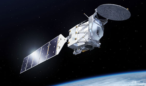
EarthCARE
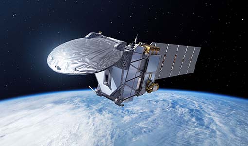
EarthCARE will examine the role clouds and aerosols play in trapping infrared radiation emitted from Earth's surface.
