- All Categories (60)
- Data (15)
- News (15)
- Missions (2)
- Events (14)
- Tools (2)
- Activities (2)
- Documents (10)
News - Infographics
Showcasing Fundamental Data Records for Altimetry
ESA has developed a comprehensive suite of Earth system data records as part of the Fundamental Data Records for Altimetry (FDR4ALT) project.
Data - EO Sign In Authentication (Open)
Ocean Waves Thematic Data Product [ALT_TDP_WA]
This is the Ocean Waves Thematic Data Product (TDP) V1 resulting from the ESA FDR4ALT project and containing Significant Wave Height estimates for the ERS-1, ERS-2 and Envisat missions. Compared to existing datasets, the Ocean Waves TDP demonstrates notable improvements in several aspects: Great improvements for Envisat due to noise reduction from Adaptive retracker and High-Frequency Adjustment (HFA) All variables are given at 5 Hz The FDR4ALT products are available in NetCDF format. Free standard tools for reading NetCDF data can be used. Information for expert altimetry users is also available in a dedicated NetCDF group within the products. Please consult the FDR4ALT Product User Guide before using the data. The FDR4ALT datasets represent the new reference data for the ERS/Envisat altimetry missions, superseding any previous mission data. Users are strongly encouraged to make use of these datasets for optimal results.
Event - Workshop
URBIS24
URBan Insights from Space (URBIS24) Workshop will offer an insightful exploration of urban challenges and innovative EO-integrated solutions.
Document - Product Handbook

SAR Tropical Atmospheric Phenomena Handbook
ERS SAR Tropical Atmospheric Phenomena Handbook.
News - Thematic area articles
How to use space data to probe humankind’s ancient past
Data disseminated by ESA’s Third Party Missions (TPM) programme are enabling archaeological investigations that could help to unravel the mysteries of past societies and cultures.
Document - Newsletter

Earth Online Newsletter 01 December 2023
This issue of the Earth Online Newsletter covers a selection of the latest news and events from ESA.
News - Success Stories
New CryoSat data to boost understanding of the oceans
A new CryoSat sea level anomaly product designed to enable ocean science and the development of operational marine applications has been released.
News - Thematic area articles
How satellite data empower sustainable urban growth
Earth observation is a vital tool for facilitating the sustainable development of the world's cities, helping to ensure that urban centres keep spurring collaboration, innovation and opportunity as they continue to expand.
News - Success Stories

New worldwide dataset captures the planet in fine detail
Scientists have developed an open source planetwide dataset of high-resolution Earth observation imagery, thanks to commercial data delivered by ESA’s Third Party Missions (TPM) programme.
Activity - General activities
EO Summer Schools
ESA's series of summer schools, on Monitoring of the Earth System, aims to promote the exploitation of Earth observation (EO) data.
News - Thematic area articles

How satellite data help to shape society
Data from ESA’s Earth observation archives are improving understanding of the interactions between human activities and the environment, helping to power green economic development and boosting prosperity in Europe and beyond.
Event - Training

EO Summer School 8
ESA's series of summer schools, on Monitoring of the Earth System, aims to promote the exploitation of Earth observation data.
News - Data Release news

Spot Extended Area mode added to ICEYE on-demand portfolio
As an evolution of Spot mode, Spot Extended Area products are now available with the same resolution of Spot data (ground resolution of 1 m) but enabling to cover the area of 225 km2 (15 x 15 km) in a single SAR image.
News - Infographics
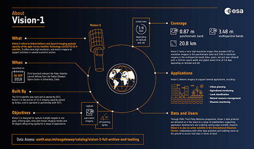
An overview of the very high-resolution Vision-1 satellite
Learn about Vision-1, which joined ESA's Third Party Missions programme in May, in our new infographic.
Activity - Projects

Contribution of Swarm data to the prompt detection of Tsunamis and other natural hazards
The main objective of COSTO (Contribution of Swarm data to the prompt detection of Tsunamis and other natural hazards) project is to better characterise, understand and discover coupling processes and interactions.
News - Infographics

PlanetScope and SkySat - The high-resolution nanosatellite constellation
Find out more about the PlanetScope and SkySat missions in our new infographic.
News - Success Stories

10 years of Envisat data help to illuminate ocean processes
A decade after Envisat beamed its final image to the planet, the pioneering ESA mission is continuing to foster improved understanding of Earth’s systems.
News - Infographics
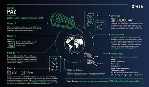
An overview of the PAZ SAR satellite mission
Learn more about the PAZ mission, a Spanish X-Band SAR satellite and part of ESA's Third Party Missions programme, in our latest infographic.
Event - Workshop

2007 International Geohazards Week
The ESA event was part of the United Nations International Year of Planet Earth, to increase awareness of the importance of Earth sciences for the advancement of sustainable development.
Event - Workshop
SEASAR 2006
ESA organised it's first SAR oceanography workshop, SEASAR 2006, entitled "Advances in SAR Oceanography from Envisat and ERS missions"