- PROBA-V
- Data
- Products Information
PROBA-V Products Information
PROBA-V 1 km, 333 m, and 100 m products (Level-1C & 3)
This page provides information about what products (including product content and processing levels) and datasets are available for the PROBA-V mission.
- 1 km and 300 m products: Data available from October 2013 onward
- 100 m products: Data available from March 2014 onward, the geometric accuracy for the data before March 2014 was sub-optimal and not adequate for 100 m resolution due to an issue with the star tracker on-board software (The issue was solved on March 2014 with the update of the on-board software).
A new collection of PROBA-V data, namely Collection 2 (C2), was released in April 2023 after almost a year of processing. The valuable datasets have been reprocessed to improve the data quality and useability. The changes will impact all Level-2A and Level-3 data at all resolutions (100 m, 300 m, and 1 km) for the operational period of the mission, being 16 October 2013 to 30 June 2020.
The following processing features/techniques have been changed to improve overall product quality:
- Cloud detection algorithm
A Multi-Layer Perceptron (MLP)-based neural network algorithm is applied, with no auxiliary data dependency, resulting in significant improvements compared to the Collection 1 cloud detection for all spatial resolutions. - Radiometric Instrument Calibration Parameter (ICP) files
The absolute calibration and equalization coefficients are updated, as well as some inter-band corrections to the BLUE channel are performed. - Atmospheric correction
The Modern-Era Retrospective analysis for Research and Applications, Version 2 (MERRA-2) Aerosol Optical Thickness (AOT) dataset is used as input for the atmospheric correction. Further, using these AOT data the most appropriate aerosol model is selected.
The following features also improve product useability and interoperability:
- CEOS Analysis Ready Data (CEOS-ARD)
PROBA-V Collection 2 data will be CEOS-ARD compliant, which means that it will fulfil a set of accuracy thresholds (e.g. for surface reflectance), that essential corrections are applied, and that the product metadata are structured in a certain format. - Data format
For Collection 2, the new Cloud Optimized GeoTIFF standard, backward compatible with standard GeoTIFF, will be used in addition to the regular HDF5 file format. Using this new and state-of-the-art data format standard eases the file handling and data visualization in cloud environments. - New product search catalogue
PROBA-V Collection 2 data will become more easily searchable using the OpenSearch CAtalogue for Remote Sensing (OSCARS) from a new, dedicated, and improved user interface, combining the best from PROBA-V’s Mission Exploitation Platform (such as time series and viewing) to give you a seamless user experience and to efficiently analyse the Collection 2 data.
Algorithm Theoretical Baseline Document (ATBD)
The PROBA-V ATBD for the geometric and radiometric processing is available here:
The values of the different radiometric and geometric parameters are stored in the Instrument Calibration Parameters (ICP) files. The latest information on Radiometric and Geometric Quality is given in the Quarterly Image quality reports.
Reference Scientific Paper
The following scientific paper provides relevant information about PROBA-V products content and quality:
W. Dierckx, et al. "PROBA-V mission for global vegetation monitoring: standard products and image quality", IJRS, 2014.
Products Content Overview
PROBA-V products are available to the users as:
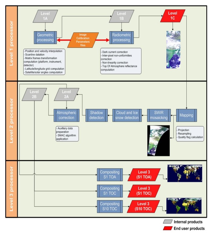
- Segment products (Level-1C): Similar to SPOT-VGT P-products, they consist of raw data, which is geo-located and radiometrically calibrated to TOA (Top Of Atmosphere) reflectance values.
- TOA products (Level-2A): Top Of Atmosphere reflectance in the four bands: Blue, Red, NIR and SWIR radiometrically and geometrically corrected, projected to a Plate Carrée grid, provided as full segments (not tiled) and resampled to the chosen spatial resolution
- Synthesis products (Level-3): 1 and 10 days synthesis for 1 km and 300 m, 1 and 5 days synthesis for the 100 m products, they are similar to SPOT-VGT S-products and consist on Level-1C data, which have been further processed with the following processing steps:
- Mapping into lat/lon WGS84 projection
- Mosaicking for the SWIR band
- Detection of clouds, clouds shadows and snow/ice
- Compositing procedure (using a Max NDVI method with constraints on SZA for 1 km and SZA+VZA for 300 m and 100 m)
- Atmospheric Correction (using SMAC method) for TOC (Top Of Canopy) products.
Access to PROBA-V products is available through the VITO Product Distribution Portal.
The PROBA-V Vegetation Raw products (Level-1C/P) and synthesis products (S1 = daily, S5 = 5 days, S10 = decade) ensure coverage of all significant landmasses worldwide with, in the case of a 10-day synthesis product, a minimum effect of cloud cover, resulting from selection of cloud-free acquisitions during the 10-day period. It ensures a daily coverage between Lat. 35°N and 75°N, and between 35°S and 56°S, and a full coverage every two days at the equator.
The Vegetation instrument is pre-programmed with an indefinite repeated sequence of acquisitions. This nominal acquisition scenario allows a continuous series of identical products to be generated, aiming to map land cover and vegetation growth across the entire planet every two days.
The PROBA-V Vegetation synthesis products are divided into so-called granules, each measuring 10 degrees x 10 degrees, each granule being delivered as a single file.
PROBA-V Products generation/processing level:
| Processing Level | Products Content Description | Delivered Products |
| Raw | Communication frames, as delivered by the Data Reception Station (DRS) | |
| Level-0 |
| |
| Level-1A | Instrument data annotated with instrument and platform housekeeping as well as ancillary (position, velocity, pointing) information. All meta data needed for the following processing step towards Level-1B included. Instrument data is unprocessed, at full resolution, time-referenced. | |
| Level-1B | Level-1A plus associated geometry derived information at pixel level | |
| Level-1C | Level-1B that is radiometrically corrected at pixel level: unprojected Top Of Atmosphere (TOA) reflectance | Level-1C |
| Level-2A | Level-1C that is mapped and projected onto a uniform space grid, corrected for cloud, ice/snow and show artifacts (projected TOA reflectance) | Level-2A |
| Level-2B | Atmospherically corrected Level-2A data. Top Of Canopy (TOC) reflectance, projected and mapped on a uniform space grid scale. | |
| Level-3 | TOA and TOC reflectances composited over defined time frame: 1 day, 10 days, 5 days (only for 100 m). | S1, S10, S5 |
The PROBA-V Data Products are:
| Processing Level | Synthesis | Resolution | Reflectance |
|---|---|---|---|
| Level-1C | - | ||
| Level-3 | S1 | 100 m | TOA |
| TOC | |||
| TOC NDVI | |||
| 333 m | TOA | ||
| TOC | |||
| 1 km | TOA | ||
| TOC | |||
| S5 | 100 m | TOA | |
| TOC | |||
| TOC NDVI | |||
| S10 | 333 m | TOC | |
| TOC NDVI | |||
| 1 km | TOC | ||
| TOC NDVI | |||
Product Specifications
| Projection | Plate carrée |
| Spectral bands | All 4 + NDVI |
| Format | HDF5 & GeoTiFF |
Information and access to the products listed below can be found on the PROBA-V 1 km, 333 m and 100 m products page.
- PROBA-V Level-1C: Radiometrically corrected Level-1B data (i.e. unprojected TOA reflectance), given per strip/camera. Pixel digital numbers are converted to radiance values. Image remains in raw sensor geometry (unprojected).
- PROBA-V S1 TOA (at 1 km and 333 m): PROBA-V Level-3 Top Of Atmosphere (no atmospheric corrections applied) daily synthesis product at 1 km spatial resolution containing:
- Top Of Atmosphere reflectance in the four spectral bands corresponding to the selected measurement, without atmospheric correction being performed
- Normalized Difference Vegetation Index (NDVI). This should be considered as a first example of a widely accepted surface parameter, and capabilities to include other quantities derived from surface reflectance should be preserved in the system
- Geometric viewing conditions
- Reference to date and time of selected measurement
- Information on the composite status map (containing identification of snow, ice, shadow, clouds, land/sea for every pixel).
The datasets are resampled to a fixed grid in the Plate Carrée (equidistant) projection at 1 km spatial resolution.
- PROBA-V S1 TOC (at 1 km and 333 m): PROBA-V Level-3 Top Of Canopy (atmospheric corrections applied) daily synthesis product at 1 km spatial resolution containing:
- Top Of Canopy (ground surface) reflectance in the four spectral bands corresponding to the selected measurement, the atmospheric correction being performed using the SMAC procedure
- Normalized Difference Vegetation Index (NDVI). This should be considered as a first example of a widely accepted surface parameter, and capabilities to include other quantities derived from surface reflectance should be preserved in the system
- Geometric viewing conditions
- Reference to date and time of selected measurement
- Information on the composite status map (containing identification of snow, ice, shadow, clouds, land/sea for every pixel).
The datasets are resampled to a fixed grid in the Plate Carrée (equidistant) projection at 1 km spatial resolution.
- PROBA-V S10 TOC (at 1 km and 333 m): Decadal synthesis of S1's as Maximum Value Compositing (MVC). PROBA-V Level-3 Top Of Canopy (atmospheric corrections applied) ten-daily synthesis product at 1 km spatial resolution containing:
- Top Of Canopy (ground surface) reflectance in the four spectral bands corresponding to the selected measurement, the atmospheric correction being performed using the SMAC procedure
- Normalized Difference Vegetation Index (NDVI). This should be considered as a first example of a widely accepted surface parameter, and capabilities to include other quantities derived from surface reflectance should be preserved in the system
- Geometric viewing conditions
- Reference to date and time of selected measurement
- Information on the composite status map (containing identification of snow, ice, shadow, clouds, land/sea for every pixel).