- GeoEye-1
- Mission
- GeoEye-1 Overview
GeoEye-1 Overview
Mission Background
GeoEye-1 (formerly known as OrbView-5) was a next-generation high-resolution imaging mission of GeoEye, based in Dulles, VA, United States. A company called OrbImage acquired a second, Space Imaging, in 2005. In January 2006, the commercial imaging company GeoEye Inc. was formed from the merger of the two. The newly formed GeoEye company became the world's largest commercial satellite imagery provider and at the time of its launch, GeoEye-1 was the world's highest-resolution commercial Earth-imaging satellite.
GeoEye-1 was manufactured in the United States by General Dynamics.
Google, which had its logo on the side of the rocket, has exclusive online mapping use of its data. While GeoEye-1 is capable of imagery with details the size of 41 cm per pixel, that resolution was only available to the U.S. government. Google has access to details of 50 cm per pixel. Prior maximum commercial imagery was 60 cm. The National Geospatial-Intelligence Agency and Google paid a combined US$502 million for the satellite and upgrades to GeoEye's four ground stations.
The satellite was acquired by Maxar in the purchase of GeoEye.
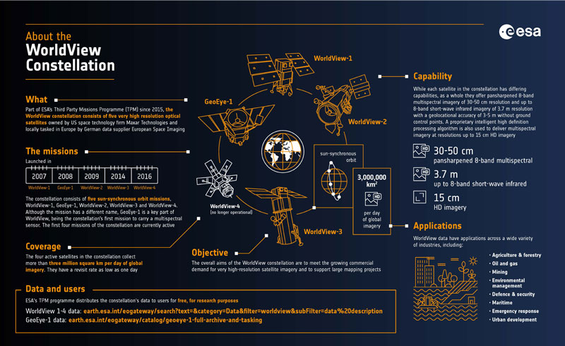
WorldView constellation infographic
Learn about Maxar’s WorldView constellation, which is part of ESA’s Third Party Missions programme, in our latest infographic:
Satellite Design
The spacecraft design is based on the SA-200HP standard modular bus (of Coriolis and SWIFT heritage). GeoEye-1 is 3-axis stabilised with a sophisticated attitude control system to provide a highly stable, while also highly agile imaging platform. A body-pointing capability of up to ± 60° is being provided, made possible by enhanced reaction wheels (low jitter). The image geolocation accuracy is = 3 m. The S/C design is fully redundant with an operational life of seven years - the expected life is more than 10 years.
| Mass | 1955 kg |
| Dimensions | 4.35 m × 2.7 m (with arrays stowed) |
| Design Lifetime | 7 years |
Mission Operations
GeoEye-1 is in a Sun-synchronous orbit with an operating altitude of 681 km.
The main ground station is situated in Dulles, Virginia, United States. GeoEye has built a fully integrated receiving, processing, and distribution network for delivering high-quality imagery products to customers around the world.
During late summer of 2013 the orbit altitude of the GeoEye-1 satellite sensor was raised to 770 km. GeoEye-1 new nadir ground sample distance (GSD) is 46 cm compared to the previous GSD of 41 cm.
Related Links
*The information provided is sourced and updated by external entities. For further details, please consult our Terms and Conditions page.