- Biomass
- Mission
- Biomass Overview
Mission Overview
Mission Background
Forests perform an essential role in the carbon cycle, absorbing carbon dioxide from the atmosphere and, through net primary production, storing it in biomass and soil. Wildfires, drought, deforestation and degradation can also release large amounts of carbon dioxide into the atmosphere.
Through the process of carbon sequestration, forests also play an important role as carbon sinks, by reducing the concentration of greenhouse gases in the atmosphere. Forests hold approximately 70% of total ecosystem carbon on land, particularly tropical forests.
The ability of forests to sequester carbon and regulate the climate is under threat from deforestation, degradation, and climate change. While field sampling suggests that carbon sequestration is stable in African tropical forests, it is declining in Amazonian tropical forests.
Due to the critical role forests play it is essential to understand what is driving deforestation and degradation, how this affects ecosystems, and what capacity they will have to store carbon in the future.
Currently, it is a major challenge of the scientific community to accurately estimate the amount of carbon stored in forests. This is derived from estimating above ground forest biomass and by measuring forest structures, but forests by nature vary greatly due to factors such as their age, species, soil type and human interaction.
Traditional methods to monitor forests were limited to in-situ observations, restricting the coverage and how often monitoring took place. The use of airborne and terrestrial lidar in recent decades has been used to complement forest inventories, but does not provide the wide area monitoring satellites offer.
Biomass is designed to address these challenges by acquiring repeated P-Band Synthetic Aperture Radar (SAR) data, on a hectare scale, of Earth’s forests.
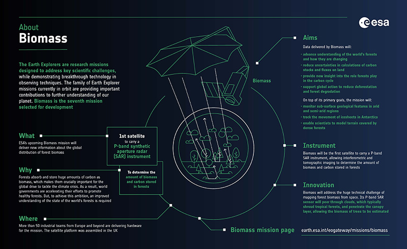
Learn about ESA's Biomass mission, which is dedicated to gathering information about the global distribution of forest biomass, in this infographic.
Satellite Design
The Biomass mission consists of a single LEO (Low Earth Orbit) satellite platform carrying a Synthetic Aperture Radar (SAR) instrument. ESA's forest mission is designed to provide P-band SAR measurements to determine the amount of biomass and carbon stored in forests.
The Biomass SAR operates at 435 Mhz with a 6 MHz bandwidth and fully polarimetric transmit and receive chain. It will operate in a stripmap mode with a swath illuminated by a single antenna beam, i.e. an imaging configuration similar to that of the ERS-1/2 SAR. Global coverage is obtained by the interleaved stripmap operations among three complementary swaths.
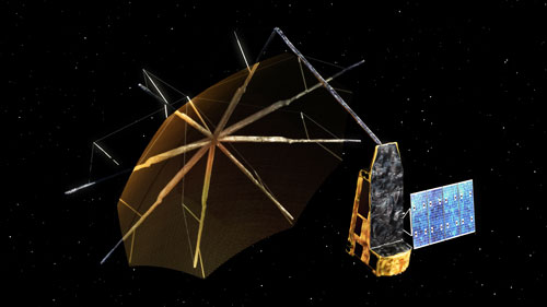
The antenna aboard Biomass is based on a large deployable reflector (12 m circular projected aperture) with an offset feed array and a single-beam. The satellite configuration is strongly constrained by the accommodation of the very large reflector antenna inside the Vega launcher. This large antenna must be folded for launch and deployed in orbit to form a stable aperture throughout the mission's life.
Exploiting the unique sensitivity of P-band SAR together with advanced retrieval methods, maps of forest biomass and forest height at a resolution of 200 m will be generated. In addition, the mission will have an experimental 'tomographic' phase during its first year of operations to provide 3D views of forests. This is necessary, as the global mass of trees is not obtainable by ground measurement techniques.
Satellite specifications:
- Dimensions: three-axes stabilised platform 10 m high, 12 m wide and 20 m long (including large reflector)
- Mass: 1170 kg (including 67 kg fuel)
- Instrument: synthetic aperture radar operating at P-band (435 MHz); fully polarimetric
- Power: 1.5 kW deployable solar array with 6.8 m2 triple junction GaAs cells; 144 Ah Li-ion battery
- Mission life: Five years (including a tomographic phase of one year)
Mission Operations
Biomass operates in a Sun-synchronous near circular dawn-dusk orbit (LTAN of 06:00 hours) at an altitude of 666 km and inclination of 97°, depending on the different mission phases.
The orbit is designed to enable repeat pass interferometric acquisitions throughout the mission's life and to minimise the impact of ionospheric disturbances. The satellite’s near-repeat cycle is three days. The baseline observation principle is based on double-baseline interferometric acquisitions.
The SAR will operate in a standard stripmap left-looking imaging geometry. The satellite will roll in orbit, enabling access to three swaths.
The swath modes will operate at the following incident angle ranges per swath:
- Swath 1: From 23° to 27.79°
- Swath 2: From 27.06° to 31.18°
- Swath 3: From 30.49° to 33.90°
These ranges result in an overlap of about 10 km.
Following the launch of Biomass on 29 April 2025, the In-Orbit Commissioning Phase took place until 20 November. During this phase, expert teams calibrated, characterised and verified the performance of the instrument and satellite system.
Biomass will operate in two phases:
- The Tomographic phase started on 21 November 2025 at 00:29:45 UTC. This is an experimental phase, which is being performed during the first year of operations. During this phase, the SAR will acquire a tomographic stack of seven images for each point in the acquisition mask.
- The Interferometric phase is the nominal operational phase of the mission and will take place for the duration of the mission after the Tomographic phase ends. During this phase, the SAR will acquire an interferometric stack of three images for each point in the acquisition mask.
When the instrument completes its defined stack of images, the satellite will perform a roll manoeuvre to enable access for the next swath. This process will continue in a repeating pattern – defined as a Major Cycle - to cover the three swath modes over a 63-day period during the Tomographic phase, and 27 days during the Interferometric phase. Once seven Major Cycles are complete, the satellite will have covered the entire globe, forming a Global Cycle. A Global Cycle will consist of 504 days during the Tomographic phase, and 273 days during the Interferometric phase.
The goal of Biomass is to cover forest areas between 75° North and 56° South. This coverage is limited by the operations of the United States Department of Defence Space Object Tracking Radar (SOTR). Biomass will be unable to operate within line-of-sight of the SOTR radars, which mainly excludes North America and Europe.
This restriction is not expected to affect the mission objectives, as the critical areas to measure are outside of these regions, as shown in the observation mask.
Biomass is supported through a number of ground facilities:
- Mission control: ESA's European Space Operations Centre (ESOC) in Darmstadt, Germany
- Communication links: ESA's ground stations at Kiruna, Sweden, and Innuvik, Canada, via X-band downlink (310/520* Mbit/s) for science data; via S-band uplink (64 kbit/s) and downlink (128 kbit/s) for tracking, telemetry and command
- Data: Management and processing at ESA's Centre for Earth Observation (ESRIN) in Frascati, Italy
- Project and commissioning: managed at ESA's European Space Research and Technology Centre (ESTEC) in Noordwijk, Netherlands