Transforming space data into climate action
ESA’s Earth observation activities are playing a key role in the global drive to combat climate change.
For decades, Earth observation satellites have been collecting data on Earth's systems. By analysing these data, scientists can reveal how Earth's environment is evolving, providing insight into the impacts and drivers of climate change.
Some of these missions include several non-operational Heritage Missions, such as ESA’s European Remote Sensing (ERS) satellite programme, and Envisat.
Through ESA’s Heritage Space programme, Heritage data are maintained, made accessible, and continuously improved, so that they can be combined with information from active missions to build continuous pictures of the environment.
Observations from ERS and Envisat have been critical in monitoring changes to the ice sheets, which, together with glacier mass loss, are now the dominant contributors to global sea level rise.
These missions have also helped to monitor many other indicators and causes of climate change, such as greenhouse gas emissions, sea surface temperature and others.
ESA is also advancing our understanding of climate change through its Earth Explorers programme. This series of missions focuses on studying the complex interactions between Earth's systems.
Launched in 2010, CryoSat was ESA's first Earth Explorer. The mission uses its SAR/Interferometric Radar Altimeter to measure the thickness of polar sea ice and monitor changes in ice sheets and glaciers around the world.
Thanks to its design and near-polar orbit, the satellite surveys regions of Antarctica that were beyond the reach of previous altimeter missions. Using these data, scientists have gained new insights into the ice loss affecting the continent.
The Soil Moisture and Ocean Salinity (SMOS) mission, another Earth Explorer, also plays a crucial role in climate action.
SMOS provides global data on variations in soil moisture and sea surface salinity, driven by the ongoing exchange of water between the oceans, atmosphere and land. These geophysical parameters are critical for improving climate change models.
ESA is further improving scientists' understanding of the climate by disseminating data collected by a number of international partner missions through the agency's Third Party Missions (TPM) programme.
Canadian remote sensing constellation GHGSat, for instance, can detect and quantify emissions of planet-warming emissions from point sources as small as individual oil and gas wells.
This has the potential to improve our understanding of how emissions from industrial facilities contribute to climate change, and to help industry take action to reduce these emissions.

Announcement of opportunity for FLEX cal/val
FLEX Test Products

FLEX Objectives
FLEX Overview
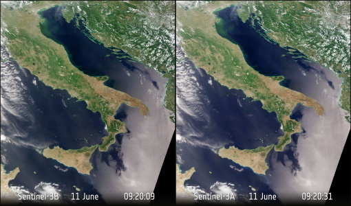
Sentinel-3 OLCI Tandem 2018
SoyFLEX II 2016
FLEX EU 2014

SoyFLEX 2015
scroll for more information