Vegetation (VGT) Cal/Val
Calibration Introduction
The mission Principal Investigator (PI) has the possibility to request specific calibration activities. These are crucial for maintaining the quality of the scientific data and for correcting for instrument degradation. On average three specific calibrations are executed every day, they include acquisition over specific ocean sites for Rayleigh, Deep Convective Clouds and Sun glint calibration, while desert site calibration is part of nominal acquisition. To limit the load on the Mission Operations Centre for these regular activities, the calibrations activities are also automated.
In calibration mode, first the required off-pointing is commanded (if any), followed by the reconfiguration of the instrument. For calibration activities, typically, different instrument settings are required compared to nominal observations. This is not limited to instrument settings only, but can also include changes in the compression ratios of the science data (some calibrations require uncompressed data for example).
A special calibration request is the moon calibration. As this is not a zone on Earth and the calibration is executed once every 28 days based on a specific moon phase angle, the handling of this request is slightly different from the other calibration requests. The moon requests have a separate onboard queue and the required maneuver is calculated on the ground due to the sporadic nature of the request.
Cal/Val Plan
Download PROBA-V Cal/Val Plans for the radiometric and geometric calibration:
Cal/Val scientific papers
Additional details on the PROBA-V Ca//Val is available in the following scientific papers:
- Sterckx et al., "In-Orbit Radiometric Calibration and Stability Monitoring of the PROBA-V Instrument", Remote Sens., 2016
- Govaerts et al., "Use of simulated reflectances over bright desert target as an absolute calibration reference", RSL, 2014
- Sterckx et al., "The PROBA-V mission: image processing and calibration", IJRS, 2014
- Sterck et al., "Rayleigh, Deep Convective Clouds, and Cross-Sensor Desert Vicarious Calibration Validation for the PROBA-V Mission", IEEE TGARS, 2013
Cal/Val Commissioning Phase Reports
Download the Cal/Val reports describing the results of the Commissioning Phase:
Calibration Activities
PROBA-V has no onboard calibration device, therefore the in-flight calibration is performed using Vicarious Calibration methods based on acquisition of specific target on-ground. Calibration measurement acquisition, processing and analysis is fully automatic and it is performed by the Cal/Val facility (OSCAR - Optical Sensor Calibration with simulated Radiances) developed by the Image Quality Center (IQC) at VITO. The usage of such vicarious calibration approaches allows to meet the goal requirements for the mission, i.e., 5% and 3% in absolute and relative radiometric accuracy, 300m and 100m in absolute and relative geometric accuracy.
Cal/Val acquisitions during PROBA-V nominal operations are summarised below, as described by the Cal/Val Plans for radiometry and geometry.
Daily Calibration acquisition
- Acquisition over defined oceanic sites, used for Rayleigh Calibration
- Acquisition over defined oceanic cloudy sites, used for Deep Convective Clouds Calibration
- Acquisition over a number of oceanic sites, used for Sun-glint Calibration
- Nominal acquisition over desert site (Libya-4) for radiometric absolute calibration and stability monitoring
- Camera to camera bias adjustment using nominal acquisition
- Geometric Calibration based on Ground Control Points (GCP) and nominal acquisition
- Antarctica (only during December/January): acquisition in compressed mode (at least) three to four times a day; during one week daily for two orbits acquisition in uncompressed mode
- Greenland (only during June/July): during one week daily acquisitions in uncompressed mode
Weekly Calibration acquisition
- Dark current (oceans night) acquisition of at least 500 lines during night for each of the integration times over one site. At new moon these data could be acquired during the same night
Monthly Calibration acquisition
- Moon observations at a phase angle of 7°, used for radiometric stability monitoring
6-Monthly Calibration
- Linearity Check for each band for five targets
- At least 45000 lines for each pixel of miscellaneous sites (April/October)
Ad-hoc Calibration/Validation
- Cross-comparison with other optical sensors (e.g., Landsat) over Pseudo-Invariant Calibration Sites, such as Libya-4
- Apex underflight cross-comparison
Validation Activities
The radiometric and geometric accuracy of the instrument was routinely validated using a combination of vicarious calibration methods (e.g., Desert, Rayleigh, Deep Convective Clouds). A detailed description of some of these methods are available.
The results of the routine vicarious calibration processing are available on a quarterly basis in the "Image Quality Reports" generated by VITO.
The current results for geometric and radiometric accuracy verification are summarised below.
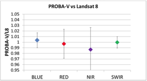
- Radiometric accuracy: The absolute and relative radiometric accuracy was periodically monitored using a combination of vicarious calibration approaches: i.e., Rayleigh, Desert and Deep Convective Clouds methods. Long-term radiometric stability was additionally verified using pseudo-invariant calibration sites (Libya-4 desert), which were acquired as part of the nominal planning, and special moon observations, which were acquired monthly with a special pitch manoeuver (360° rotation). The radiometric performances retrieved with these methods were excellent and very stable along the mission: absolute and relative radiometric accuracies were respectively better than 5% and 3%, radiometric stability is well within 3%. Cross-comparison with Landsat-8 showed an agreement of better than 2% for all bands as summarised in Fig.1, detailed results of this inter-comparison are available.
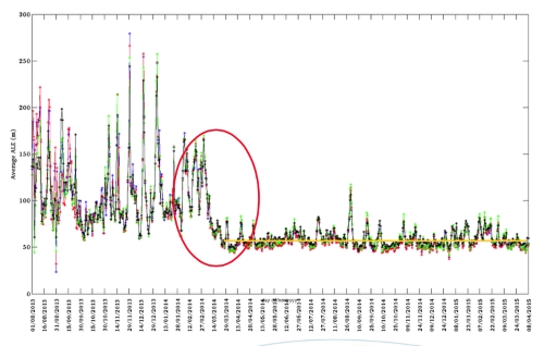
- Geometric accuracy: The absolute and relative (inter-band) geo-location accuracy was monitored daily using ground control points, extracted from the Landsat GeoCover dataset. This monitoring allowed to detect an issue with the onboard handling of the star tracker attitude data during the first months of 2014, owing to this anomaly a significant degradation of the geometric accuracy was observed. After a long investigation, the root cause of the problem was found and the issue was solved on 10 March 2014 by applying an onboard patch. Since that date the geometric performances of PROBA-V remain at an excellent level and very stable (see Fig.2), with an average absolute geo-location error of better than 50m and a relative error as low as 32 m for the RED-NIR bands.
Download an animation showing the daily absolute geolocation error (m) in the across-track and along-track direction during the first months of the PROBA-V mission.
The impact of the star-tracker onboard anomaly is clearly observed in the first days of the animation and up to March 2014, when the upload of a SW patch allows to solve the attitude problem and significantly improve the geolocation accuracy. The different colours represent the four PROBA-V bands, and the circles are respectively the goal requirements for absolute geolocation in the VNIR (300m) and in the VNIR+SWIR (450m). We can clearly see that after the correction of the onboard star-tracker anomaly both goal requirements are always met.