earth online
  • Explore Missions
    • Earth Explorers
    • Heritage Missions
    • Third Party Missions
  • Explore Data
    • All Data
    • Open Data
    • Announcement of Opportunity
    • Project Proposal
    • Sample Data
    • Dashboard
  • Explore Tools
    • Analysis Tools
    • Processing Tools
    • Visualisation Tools
    • Catalogues
    • Apps
  • Explore News & Events
    • All News
    • Data Release News
    • Maintenance News
    • Operational News
    • All Events
    • Events Updates
    • Workshop
    • Conference
  • Explore Learn & Discover
    • Data Application Articles
    • Spotlight on EO Community
    • Gallery
    • FAQ
    • Success Stories
    • Infographics
    • Quality Reports Advanced Search
  • SEE ALL
  • Landsat-8
  • Landsat-8
  • Landsat Series
  • Mission
    • Landsat-8 Overview
    • Landsat-8 Objectives
  • Instruments
    • Operational Land Imager (OLI)
      • Explore Operational Land Imager (OLI)
      • Operational Land Imager (OLI) Overview
      • Operational Land Imager (OLI) Cal/Val
      • Operational Land Imager (OLI) Quality Control Reports
      • Operational Land Imager (OLI) Products Information
    • Thermal Infra-Red Sensor (TIRS)
      • Explore Thermal Infra-Red Sensor (TIRS)
      • Thermal Infra-Red Sensor (TIRS) Overview
      • Thermal Infra-Red Sensor (TIRS) Cal/Val
      • Thermal Infra-Red Sensor (TIRS) Quality Control Reports
      • Thermal Infra-Red Sensor (TIRS) Products Information
More
    • Missions
    • Landsat-8
    • Instruments
    • Operational Land Imager (OLI)
    • Explore Operational Land Image...

    Operational Land Imager (OLI)

    The Operational Land Imager (OLI), on board Landsat-8 measures in the visible, near infrared, and short wave infrared portions of the spectrum. Its images have 15 m panchromatic and 30 m multi-spectral spatial resolutions along a 185 km wide swath, covering wide areas of the Earth’s landscape while providing sufficient resolution to distinguish features like urban centres, farms, forests and other land uses. The entire Earth falls within view once every 16 days due to Landsat-8’s near-polar orbit.

    The Landsat Operational Land Imager (OLI) uses a technological approach demonstrated by the Advanced Land Imager (ALI) sensor flown on NASA's experimental EO-1 satellite, which operated from 2000 to 2017.

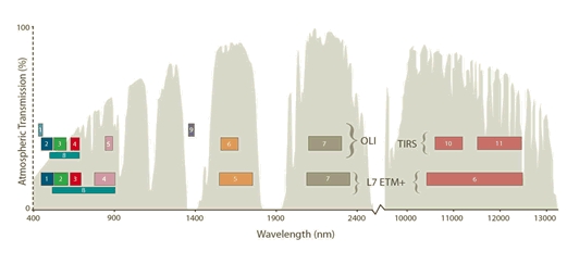
    OLI provides two new spectral bands in respect to the Landsat-7 ETM+ instrument, one tailored especially for detecting cirrus clouds (band 9, new Near Infra-Red (NIR) band) and the other for coastal zone observations (band 1, new deep blue visible channel). It measures in the visible, NIR, and Shortwave Infra-Red (SWIR) portions of the electromagnetic spectrum and offers 15 m panchromatic, and 30 m multi-spectral (VIS/NIR/SWIR) spatial resolution. The scene size is 185x180 km.

    OLI was built by the Ball Aerospace & Technologies Corporation.

    OLI Band Information
    Band No.Band NameSpectral Range (nm)Use of data
    1New Deep Blue433-453Aerosol/coastal zone
    2Blue450-515Pigments/scatter/coastal
    3Green525-600Pigments/coastal
    4Red630-680Pigments/coastal
    5NIR845-885Foliage/coastal
    6SWIR 21560-1660Foliage
    7SWIR 310.4-12.5 (TIR)Plant heat stress, thermal mapping, soil mapping
    8PAN500-680Image sharpening
    9SWIR1360-1390Cirrus cloud detection


    Landsat bands
    Landsat bands


    For further information, see OLI on the NASA website.

    FIND OUT MORE
    Tweet
    Share

    Featured

    • HEDAVI Tutorial: How to process optical images in Explorer mode
      HEDAVI Tutorial: How to process optical images in Explorer mode
    • Coast of Croatia: As seen by Landsat-8
    • Casablanca, Morocco: As seen by Landsat-7
    • Coast of Norway: As seen by Landsat-5
    • Mount Etna, Italy: As seen by Landsat-7

    Search with keywords

    • Imaging Spectrometers/Radiometers
    • Land Surface
    • Landsat
    • Landsat-8
    • Mapping and Cartography
    • OLI
    • Passive Remote Sensing
    • Photon/Optical Detectors
    • Spectrometers/Radiometers

    People also search for

    DataNewsMissionsEventsTools and toolboxesActivitiesCampaignsLearn & Discover
    European Space Agency
    Terms and conditionsCookie NoticePrivacy NoticeContact UsFAQComplaintsLeave feedback