- All Categories (45)
- News (3)
- Missions (6)
- Events (3)
- Tools (1)
- Documents (32)
Document - Technical Note

(A)ATSR Expert Support Laboratory FAST Level 1b Product Definition
(A)ATSR Expert Support Laboratory FAST Level 1b Product Definition.pdf
Document - Conference Presentation - Poster

04_OCT2013_ESA-EO_programmes.pdf
ESA EO missions and their exploitation for science and applications ESA
Document - Technical Note

34th AATSR QWG Meeting Summary
The 34th AATSR QWG Meeting was held on 28th/29th March 2017 at RAL, Harwell, U.K. ThisMemorandum states the objectives of the Meeting, gives a selected highlight, and summarisesthe discussions that took place.
Document - Conference Presentation - Poster
7-Highres-Surface-Velocity-Monitoring-Wide-Swath-SAR.pdf
High resolution Surface Velocity Monitoring with Wide Swath SAR: A User´s Guide to the Range Doppler Method Johnny Johannessen (NERSC, Norway)
Event - Training

Advanced Training Course in Ocean Remote Sensing 2011
Background and access to current and future Chinese, ESA and TPM satellite missions in ocean remote sensing were presented
Document - General Reference

An-oceanographers-guide-to-GOCE-and-the-geoid.pdf
This article was published in Ocean Science Discussions. It gives a review of the geodetic concepts necessary for oceanographers to make use of satellite gravity data to define the geoid, and to interpret the resulting product.
Document - General Reference
Application-of-satellite-remote-sensing-to-developing-countries.pdf
This booklet is a preliminary copy of the first set of viewgraphs being prepared by Satellite Observing Systems (SOS) for ESA to support Agencies activities for promoting the use of Earth observation data from space in various environmental disciplines and applications for developing countries.
Document - Technical Note
Draft-specification-of-ATSR-SADIST-2-products.pdf
This document is a draft specification of the scientific products from RAL's SADIST-2 ATSR data-processing software. Since SADIST-2 is being developed such that it can process data from both ATSR-1 and ATSR-2 instruments, the products described here have been designed to be sufficiently flexible and modular that they are equally valid for either instrument.
Document - Proceedings

Dragon Programme Mid-Term Results
Proceedings of the 2005 Dragon Symposium held on 27 June - 1 July 2005 in Santorini, Greece.
Document - General Reference
Earth-Observation-from-Space-supporting-Biodiversity-Conservation.pdf
This brochure provides an overview of the ESA-funded Diversity project, which aims to demonstration the contribution Earth observation makes towards monitoring the trends and status of different marine and terrestrial ecosystems relevant to diversity.
Document - General Reference
Earth-Observation-Services-Today-Using-Radar-from-Space.pdf
This booklet provides descriptions of EO services available today from specialist providers for the marine environment e.g. CLS (Collecte Localisation Satellites] and NERSC (Nansen Environmental and RemoteSensing Centre], Ocean Numerics, ARGOSS, MeteoMer and Satellite Observing Systems (SOS].
Mission - Earth Explorers
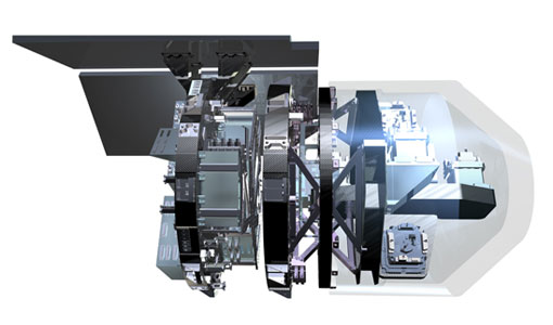
EGG
This opened a window into Earth's interior structure, as well as the currents circulating within the depths of its oceans
Event - Training
EO Summer School 6
Keynote lectures on global change issues are also given to discuss the current state of the science of global change and
Document - Proceedings
EO-Summer-School-6-ESA-explorer-mission-GOCE-earth-gravity-from-space.pdf
This presentation from ESA's EO Summer School 6 presents the ESA explorer mission GOCE earth gravity from space
Document - Proceedings
First-International-GOCE-Workshop-GOCE-Germany-Oceanography.pdf
describes using data from the GOCE satellite mission in order to determine structure and transport of the Antarctic Circumpolar Current
Document - Proceedings
First-International-GOCE-Workshop-GOCE-Netherlands-Oceanography.pdf
This presentation from ESA's First International GOCE Workshop describes the dynamics and operation of the thermohaline circulation, the global scale transport of heat and salt (and other water characteristics) by the oceans.
Document - Proceedings
First-International-GOCE-Workshop-GOCE-UK-Oceanography.pdf
This presentation from ESA's First International GOCE Workshop describes the role of GEOID in ocean modelling and assimilation
Document - Proceedings
First-International-GOCE-Workshop-IMPACT-ON-OCEANOGRAPHY.pdf
This presentation from ESA's First International GOCE Workshop describes the impact of the GOCE mission for oceanography
Document - General Reference
Globcolour-A-Precursor-to-the-GMES-Marine-Core-Service-Ocean-Colour-Thematic-Assembly-Centre.pdf
This article is extracted from ESA Bulletin Nr. 132.
Mission - Earth Explorers

GOCE
Explorer (GOCE) mission mapped Earth's geoid very accurately, opening a window into Earth's interior structure as well as the currents