- All Categories (13537)
- Data (1)
- News (48)
- Missions (18)
- Events (8)
- Tools (3)
- Activities (5)
- Campaigns (2)
- Documents (13452)
News - Success Stories

Publication of Coastal Current Intrusions from Satellite Altimetry
A new study entitled “Coastal current intrusions from satellite altimetry” has just been published in the journal Remote
News - Success Stories
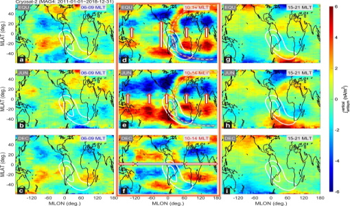
CryoSat-2 Data Used to Measure Ionospheric Currents
Recovery and Climate Experiment Follow-On (GRACE-FO) satellites can be used to diagnose weak low-/mid-latitude ionospheric currents
Document - Conference Presentation - Poster

Global-Surface-Geostrophic-Currents-From-Satellite-Altimetry-and-GOCE
Global Surface Geostrophic Currents from Satellite Altimetry and GOCE J.M. Sánchez-Reales, I. Vigo, S.G. Sin & B.F. Chao
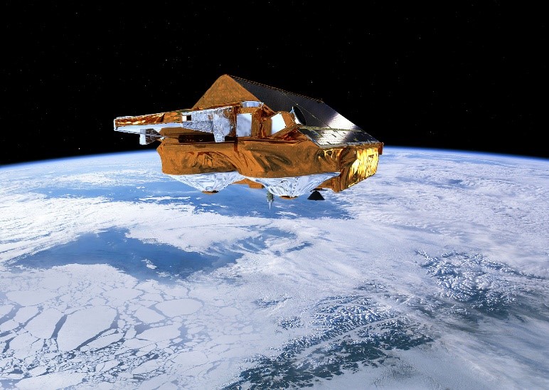
Mission - Earth Explorers

GOCE
Explorer (GOCE) mission mapped Earth's geoid very accurately, opening a window into Earth's interior structure as well as the currents
Document - General Reference

Earth-Explorers-Satellites-to-understand-our-changing-Earth.pdf
This eight-page brochure provides an overview of the Earth Explorers currently in orbit and those under development.
Document - Proceedings

First-International-GOCE-Workshop-GOCE-Germany-Oceanography.pdf
describes using data from the GOCE satellite mission in order to determine structure and transport of the Antarctic Circumpolar Current
News - Success Stories
CRYO2ICE over Antarctica: revealing further insight on changing ice
The CryoSat-2 satellite is currently being aligned with ICESat-2 over Antarctica, unlocking fresh possibilities in the wealth
Document - Software Verification Plan/Report

GUT2-WP6000-Final-Report.pdf
combined to models of the marine geoid to estimate the ocean Mean Dynamic Topography, and, by geostrophy, the ocean mean currents
News - Success Stories
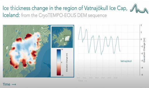
CryoTEMPO-EOLIS Products Now Available for Iceland, Svalbard, and the Canadian Arctic
Land-ice monitoring via Earth Observation methods in general, and altimetry in particular, are essential for tracking the current
Activity - Quality

EDAP
The following missions are currently being considered as part of the Automatic Identification System (AIS) and Radio Frequency
Tools - Analysis

GOCE User Toolbox
Data output formats The current data formats that GUT can provide in output are: netCDF (Climate and Forecast Metadata Convention
News - Events and Proceedings
GLOC 2023: Democratising data access key to climate action
Currently, more than a trillion tonnes of ice is lost each year.
Event - Workshop

GOCE - 4th International User Workshop 2011 sessions
On the Current Status of the Cooperative Research Project Real Data Analysis GOCE (REAL GOCE) W.-D. Schuh & B.
Activity - Instrument characterisation and algorithm studies

ESA satellites and instruments calibration landing page
Data Outages: Information currently not available online.
News - Operational News

Delay in the availability of CryoSat Products
There is currently an ongoing technical issue at the CryoSat Payload Data Ground Segment (PDGS).
News - General News
ESA's excellent Earth Explorer missions extended to 2025
Acting like the spinning conductor in a bicycle dynamo, it generates electrical currents and thus the continuously changing
Document - Conference Presentation - Poster
7-Highres-Surface-Velocity-Monitoring-Wide-Swath-SAR.pdf
High resolution Surface Velocity Monitoring with Wide Swath SAR: A User´s Guide to the Range Doppler Method Johnny Johannessen (NERSC, Norway)
Document - Conference Presentation - Poster
Estimating-North-Atlantic-Mean-Dynamic-Topography-R-J-Bingham.pdf
GOCE - 4th International User Workshop 2011 sessions presentation
Document - Proceedings
First-International-GOCE-Workshop-Geoid-Scales-from-Altimetry-and-In-Situ-Observations.pdf
This presentation from ESA's First International GOCE Workshop describes a method that can be used to derive independent Geoid estimates from a combination of altimetry and in situ data.
Document - Software Verification Plan/Report
GUT2-WP4000-Final-Report.pdf
The objective of this workpackage is to carry out an independent validation of the various preliminary geoid models computed by ESA HPF (High Processing Facility) from the GOCE (Gravity field and steadystate Ocean Circulation Explorer) mission in order to assess their quality for oceanographic applications.