- All Categories (13295)
- News (32)
- Missions (16)
- Events (4)
- Tools (1)
- Campaigns (2)
- Documents (13240)
News - Success Stories

Publication of Coastal Current Intrusions from Satellite Altimetry
A new study entitled “Coastal current intrusions from satellite altimetry” has just been published in the journal Remote
Mission - Earth Explorers

GOCE
Explorer (GOCE) mission mapped Earth's geoid very accurately, opening a window into Earth's interior structure as well as the currents
Document - Proceedings

First-International-GOCE-Workshop-GOCE-Germany-Oceanography.pdf
describes using data from the GOCE satellite mission in order to determine structure and transport of the Antarctic Circumpolar Current
News - Success Stories
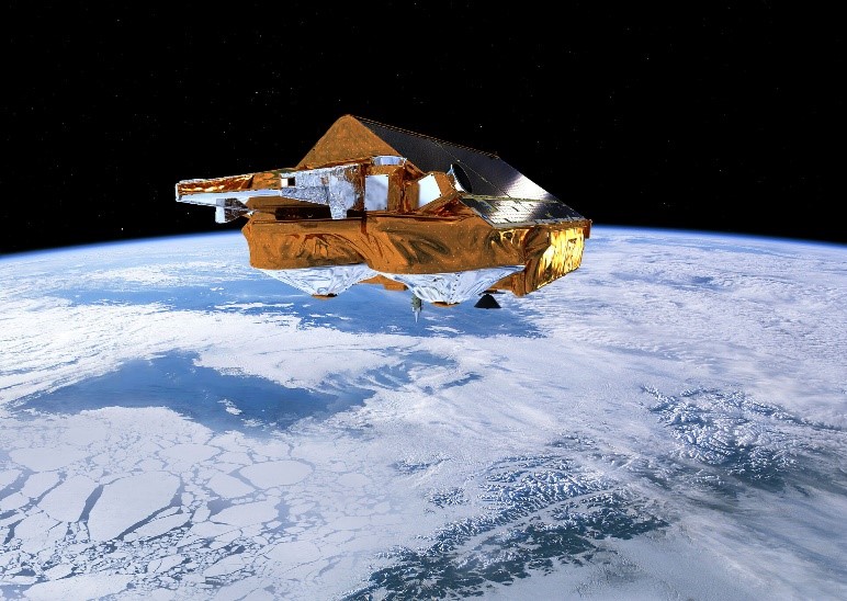
CRYO2ICE over Antarctica: revealing further insight on changing ice
The CryoSat-2 satellite is currently being aligned with ICESat-2 over Antarctica, unlocking fresh possibilities in the wealth
News - Success Stories
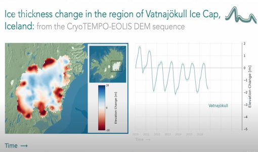
CryoTEMPO-EOLIS Products Now Available for Iceland, Svalbard, and the Canadian Arctic
Land-ice monitoring via Earth Observation methods in general, and altimetry in particular, are essential for tracking the current
Tools - Analysis

GOCE User Toolbox
Data output formats The current data formats that GUT can provide in output are: netCDF (Climate and Forecast Metadata Convention
News - General News
ESA's excellent Earth Explorer missions extended to 2025
Acting like the spinning conductor in a bicycle dynamo, it generates electrical currents and thus the continuously changing
News - Operational News

Delay in the availability of CryoSat Products
There is currently an ongoing technical issue at the CryoSat Payload Data Ground Segment (PDGS).
Document - Conference Presentation - Poster

7-Highres-Surface-Velocity-Monitoring-Wide-Swath-SAR.pdf
High resolution Surface Velocity Monitoring with Wide Swath SAR: A User´s Guide to the Range Doppler Method Johnny Johannessen (NERSC, Norway)
Document - Proceedings
First-International-GOCE-Workshop-GOCE-Netherlands-Oceanography.pdf
This presentation from ESA's First International GOCE Workshop describes the dynamics and operation of the thermohaline circulation, the global scale transport of heat and salt (and other water characteristics) by the oceans.
Mission - Earth Explorers
Geographical Mode Mask
The current operational Geographical Mode Mask v5.0 The current version of the geographical mode mask v5.0 has been in operation
Document - Proceedings
First-International-GOCE-Workshop-IMPACT-ON-OCEANOGRAPHY.pdf
This presentation from ESA's First International GOCE Workshop describes the impact of the GOCE mission for oceanography
Mission - Earth Explorers
GOCE Objectives
Thanks to this current, the coastal waters of Europe are 4°C warmer than waters at equivalent latitudes in the north Pacific
Event - Training

EO Summer School 3
In line with observations it shows anti-cyclonically rotating surface currents and cyclonically rotating bottom currents.
News - Data Release news

GOCE EGG L1b reprocessed data published
The GOCE L2 data, including the gravity field models, are currently being regenerated and will be available in Q2 2019.
Document - Proceedings
First-International-GOCE-Workshop-GOCE-UK-Oceanography.pdf
This presentation from ESA's First International GOCE Workshop describes the role of GEOID in ocean modelling and assimilation
News - Data Release news

CryoSat Ocean Baseline C reprocessed data available
The reprocessing activity is currently progressing and we are planning to publish batches of six months of data every 20
News - Data Release news
New CryoSat BUFR products for the meteorological community
The current CryoSat Ocean Processor is able to generate Near-real-time Ocean Products (NOP) with a latency of 2-3 hours after
Document - General Reference

Introduction-CryoSat-2-ICESat-2-Resonant-Orbits.pdf
This presentation describes the CRYO2ICE campaign.
Document - General Reference
Earth-Observation-from-Space-supporting-Biodiversity-Conservation.pdf
This brochure provides an overview of the ESA-funded Diversity project, which aims to demonstration the contribution Earth observation makes towards monitoring the trends and status of different marine and terrestrial ecosystems relevant to diversity.