- All Categories (3749)
- Data (94)
- News (88)
- Missions (15)
- Events (46)
- Tools (7)
- Activities (3)
- Campaigns (26)
- Documents (3453)
MISSIONS
Explore the European Space Agency's Earth Observation satellite missions. Learn all about ESA's dedicated Earth Explorers or collaborations with other agencies through the Third Party Missions programme.
Mission - Earth Explorers

SMOS
The Soil Moisture and Ocean Salinity (SMOS) mission is dedicated to making global observations of soil moisture over land and salinity over oceans.
Mission - Earth Watch

PROBA-V
The PROBA-V mission provides multispectral images to study the evolution of the vegetation cover on a daily and global basis.
Mission - Third Party Missions

PROBA-1
PROBA-1 is a technology demonstration satellite that later became an operational Earth observation mission.
Mission - Third Party Missions

SAOCOM
The SAOCOM (SAtélite Argentino de Observación COn Microondas) satellite series represents Argentina's approved polarimetric L-band SAR constellation of two spacecraft. It's objective is to provide an effective Earth observation and disaster monitoring capability.
Mission - Copernicus Sentinels

Copernicus Sentinel-1
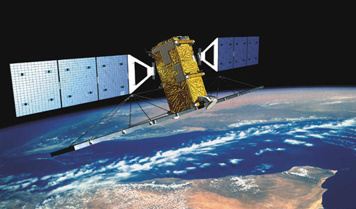
The Copernicus Sentinel-1 mission comprises a constellation of two polar-orbiting satellites, operating day and night performing C-band synthetic aperture radar imaging, enabling them to acquire imagery regardless of the weather.
Mission - Third Party Missions

WorldView-1
WorldView-1 helped meet the growing commercial demand for multi-spectral geospatial imagery.
Mission - Third Party Missions

WorldView Series
The WorldView constellation are environment-monitoring satellites that have been supplying imagery since 2007.
Mission - Heritage Missions
RADARSAT
The RADARSAT programme consists of a pair of remote sensing satellites from the Canadian Space Agency (CSA).
Mission - Heritage Missions

SPOT
The SPOT (from French "Satellite pour l'Observation de la Terre") series of missions has been supplying high-resolution, wide-area optical imagery since 1986.
Mission - Third Party Missions

SkySat
SkySat is a constellation of high-resolution Earth imaging satellites from the commercial company Planet Labs.
Mission - Third Party Missions
WorldView-3
WorldView-3 is the first multi-payload, super-spectral, high-resolution commercial satellite sensor operating at an altitude of 617 km. WorldView-3 is capable of collecting up to 680,000 square km per day.
Mission - Third Party Missions

WorldView-2
WorldView-2 is an environment-monitoring satellite from Maxar which presents images as the human eye can perceive them, creating a more realistic 'true colour' view of the world.
Mission - Third Party Missions

SPOT 6
SPOT 6, like all the SPOT missions, is aimed at supplying high-resolution, wide-area optical imagery.
Mission - Third Party Missions

IRS-R2 (ResourceSat-2)
IRS-R2 (ResourceSat-2) continues the remote sensing data services to global users provided by the ResourceSat-1 mission and also provides data with enhanced multispectral/ spatial coverage.
Mission - Third Party Missions

Pléiades
The Pléiades programme followed the SPOT programme satellite series, introducing advanced technologies in Earth observation.