- All Categories (26)
- Data (3)
- News (15)
- Missions (2)
- Events (4)
- Tools (1)
- Documents (1)
Event - Workshop

10 Years of GOME on ERS-2 Workshop
The workshop summarised 10 years of operation of the Global Ozone Monitoring Experiment (GOME) on board ERS-2.
Event - Workshop
2nd Space for Hydrology Workshop
The workshop aimed to assess the current stage of knowledge and activities in space-based hydrological observations and to exchange knowledge and know how with hydrologists and researchers.
News - Operational News
Aeolus set for Instrument Telescope Refocussing exercise
Aeolus's telescope requires periodic collimation and refocussing. To this end, the Instrument Telescope Refocussing activity aims to improve the radiometric performance of the Atmospheric Laser Doppler Instrument's telescope, ALADIN.
News - Spotlight on EO community

An overview of the SMOS mission
In this video, Klaus Scipal - Biomass and SMOS Mission Manager - talks about ESA's Soil Moisture and Ocean Salinity mission.
Data - Announcement of Opportunity (Restrained)

Announcement of Opportunity for NoR
ESA invites submissions for the Network of Resources (NoR) call, which aims to support research, development and pre-commercial users to innovate their working practices, moving from a data download paradigm towards a 'bring the user to the data' paradigm.
News - Success Stories
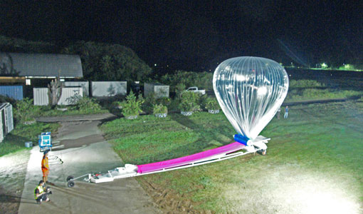
Around the world in eight balloons with Strateole-2
Strateole-2 is a French-US project supported by ESA that uses CNES superpressure balloons drifting around the globe to study the climate processes in the Tropical Tropopause Layer (TTL) and the lower stratosphere, helping Aeolus validation activities along the way.
Document - Product Handbook

AVHRR-Handbook.pdf
The AVHRR user handbook provides details about the content of the consolidated and harmonised data set archived at ESA facilities.
Mission - Heritage Missions

Envisat
Envisat was ESA's successor to ERS. Envisat carried ten instruments aboard for a wide range of Earth observing fields. The mission was operational from 2002 to 2012.
Event - Workshop
Envisat Validation Workshop 2002
The workshop covered various aspects of validation of the Envisat instruments.
News - Events and Proceedings
ESA invites scientists to submit abstracts for EGU 2023
ESA is calling for researchers to submit abstracts for sessions at the next General Assembly of the European Geosciences Union (EGU 2023).
News - Data Release news
FDR4ALT - ESA unveils new cutting-edge ERS/Envisat Altimeter and Microwave Radiometer Datasets
The European Space Agency (ESA) has developed a comprehensive suite of innovative Earth system data records as part of the Fundamental Data Records for Altimetry project - FDR4ALT.
Event - Workshop
GEWEX / ESA DUE GlobVapour Quality Assessment of Water Vapour Data Sets Workshop
The workshop brought together the producers and users of water vapour data sets to define a useful water vapour data set for GEWEX.
News - Data Release news

GOME TCWV Climate product available online
GOME Total Column Water Vapour (TCWV) Climate product developed within the ESA GOME-Evolution project is now accessible from the ESA data archives together with the ERS-2 GOME data.
News - Success Stories

How Envisat helped to shape global understanding of Earth’s systems
Twenty years have passed since a ground-breaking European spacecraft designed to deliver unprecedented insight into the planet’s changing environment was lofted into orbit.
Tools - Other

Hydrology TEP
The Hydrology Thematic Exploitation Platform (TEP) enables access, processing, uploading, visualisation, manipulation and comparison of hydrological data.
News - Infographics
Key facts about SMOS Level-1 and Level-2 science data
Learn about data products from the SMOS mission in our latest infographic.
News - Success Stories
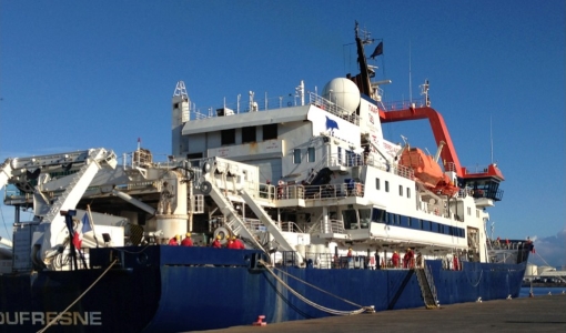
Monitoring aerosol properties in the Indian Ocean
A ship-borne photometer of CIMEL CE318-T type was permanently installed in early January 2021 aboard the French research vessel Marion Dufresne in the frame of the MAP-IO (Marion Dufresne Atmospheric Program - Indian Ocean) research programme
News - Thematic area articles
Monitoring water on Earth's surface
ESA's Earth observation satellites are playing a leading role in furthering our understanding of how Earth's terrestrial hydrosphere is being influenced by humankind.
Mission - Heritage Missions
MOS-1/1B
MOS-1 and 1B, Japan’s first marine observation satellites, were designed to monitor ocean currents, sea surface temperature, atmospheric water vapour, ocean chlorophyll levels, precipitation, and land vegetation.
News - Data Release news

New ERS-2 GOME Level 1 v5.1 dataset available online
A new GOME Level 1b dataset has been generated for the 16-year mission period bringing relevant quality improvements for the revised calibration approach, compensating aging and instrument degradation, and provide enhanced accessibility.