- All Categories (180)
- Data (1)
- News (4)
- Missions (1)
- Tools (2)
- Campaigns (3)
- Documents (169)
News - Data Release news

SMOS L2 Sea Surface Salinity products documentation updates
SMOS L2 Sea Surface Salinity product validation report is now available.
News - General News

Updated SMOS documentation available
Updated versions of several SMOS data documents are now available.
Document - General Reference

The Soil Moisture and Ocean Salinity Mission - SMOS
This document outlines the SMOS mission objectives and the derived scientific mission requirements.
Mission - Earth Explorers

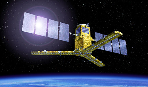
SMOS
The Soil Moisture and Ocean Salinity (SMOS) mission is dedicated to making global observations of soil moisture over land and salinity over oceans.
Data - Campaigns (Open)
LOSAC
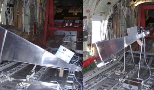
The L-band Ocean Salinity Airborne Campaign (LOSAC) objective is to understand the nature of the wind driven signatures in order to evaluate if corrections are necessary prior to salinity estimations based on the radiometer signals.
Campaign

DOMEX-1
The purpose of the DOMEX experiment was to acquire the first combined, in-situ microwave emission measurements using C- and L-band radiometers.
Campaign
LOSAC
The L-band Ocean Salinity Airborne Campaign (LOSAC) objective is to understand the nature of the wind driven signatures in order to evaluate if corrections are necessary prior to salinity estimations based on the radiometer signals.
Campaign

WISE
The objective of WInd and Salinity Experiment 2001 (WISE 2001) campaign was to get more data points and better wind speed measurements.
Tools - Visualisation
SMOS Global Mapping Tool
The SMOS Global Mapping Tool (GMT) is useful for plotting the SMOS data into a single global geographical map.
Document - Technical Note

SMOS-L1B-Data-Processing-Model-Document
The main purpose of this document is to provide a detailed definition of the processes and algorithms contained in the Foreign Sources Correction and Image Reconstruction modules for SMOS Level-1B products.
Tools - Processing
SMOS NetCDF Conversion Tool
The SMOS NetCDF Conversion Tool, for batch processing of large amounts of files, is available as a stand-alone command line executable or integrated in the SMOS Toolbox/SNAP.
News - Success Stories
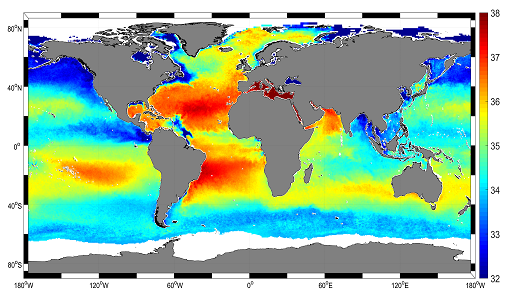
Mapping salty waters
The length and precision with which climate scientists can track the salinity, or saltiness, of the oceans is set to improve dramatically.
News - Success Stories

ESA's Earth Explorers surpassing expectations
In this video, learn how each Earth Explorer mission is contributing to Earth science, and changing the way we look at our beloved planet.
Document - Technical Note
Draft-specification-of-ATSR-SADIST-2-products.pdf
This document is a draft specification of the scientific products from RAL's SADIST-2 ATSR data-processing software. Since SADIST-2 is being developed such that it can process data from both ATSR-1 and ATSR-2 instruments, the products described here have been designed to be sufficiently flexible and modular that they are equally valid for either instrument.
Document - Technical Note
Investigation-into-ATSR-1-and-ATSR-2-data-availability.pdf
Envisat-style products for ATSR-1 and ATSR-2 data.
Document - Technical Note
SMOS-Mission-Objectives-and-Scientific-Requirements.pdf
This document outlines the SMOS mission objectives and the derived scientific mission requirements.
Document - General Reference
Getting-down-to-business-SMOS-operations-and-products.pdf
SMOS will be the first satellite mission to provide global measurements of two key variables in the water cycle, soil moisture and ocean salinity. But how do we get from the first observations to meaningful data on the various characteristics of Earth's surface?
Document - General Reference
SMOS-over-land-New-applications-for-ESAs-water-mission.pdf
This is an article extracted from the ESA Bulletin Nr. 152.