- All Categories (24)
- Data (1)
- News (2)
- Missions (2)
- Events (4)
- Tools (3)
- Activities (2)
- Campaigns (1)
- Documents (9)
News - Success Stories
Commercial and international data for fire monitoring
As climate change sparks a surge in the frequency and intensity of wildfires, satellite data disseminated through ESA’s Third Party Missions (TPM) programme are helping scientists to track and investigate these potentially damaging natural events.
Event - Training

EO Summer School 3
ESA's series of summer schools, on Monitoring of the Earth System, aims to promote the exploitation of Earth observation data.
Event - Conference

Living Planet Symposium 2022
Learn about the 2022 edition of ESA's Living Planet Symposium.
News - Data Release news
New Landsat-8 Collection-2 Level 1 and Level 2 data now available
Within ESA’s Landsat offering, access to the European coverage of Landsat-8 Collection-2 Level 1 and Level 2 data is now available.
Tools - Other

Urban TEP
The Urban Thematic Exploitation Platform enables access, processing, uploading, visualisation, manipulation and comparison of data over urban areas.
Tools - Other

Hydrology TEP
The Hydrology Thematic Exploitation Platform (TEP) enables access, processing, uploading, visualisation, manipulation and comparison of hydrological data.
Tools - Other

Forestry TEP
The Forestry Thematic Exploitation Platform (TEP) enables users in the forestry sector to access satellite data based processing services and tools for generating value-added forest information products.
Document - General Reference

Shrimp farm inventory and monitoring
This series produced by the Environment and Natural Resources Service of FAQ aims to present the possibilities of remote sensing techniques for natural resource management and planning.
Data - Campaigns (Open)

BACCHUS-DOC
The BACCHUS-DOC Radar and Optical Campaign was an area mapping project of vineyards near Frascati (Italy). ESA required high resolution geo-referenced airborne SAR data of different wavelength and polarisation (preferably polarimetric).
Campaign
BACCHUS-DOC
The BACCHUS-DOC Radar and Optical Campaign was an area mapping project of vineyards near Frascati (Italy). ESA required high resolution geo-referenced airborne SAR data of different wavelength and polarisation (preferably polarimetric).
Mission - Heritage Missions

Landsat Series
The Landsat Series is the world's longest running system of satellites for moderate-resolution optical remote sensing for land, coastal areas and shallow waters.
Activity - Quality

EDAP
The ESA Earthnet Data Assessment Pilot (EDAP) project will perform assessments for various missions to ensure the delivered data is fit for purpose.
Activity - Quality
SLAP
The SLAP (Systematic Landsat Archive Processing) project covers the MSS, TM and ETM+ products from Landsat missions 1 – 7, and is the first systematic reprocessing of the ESA Landsat archive.
Event - Workshop

IDEAS+ Cal/Val Workshop 7
The 7th IDEAS+ Cal/Val Workshop took place on 4 and 5 June 2019 and it was hosted at the Wageningen University and Research (WUR) in The Netherlands.
Event - Meeting

VH-RODA and CEOS SAR workshop
The workshop provided an open forum for the presentation and discussion of current status and future developments related to the calibration and validation of space borne very high-resolution SAR and optical sensors and data products.
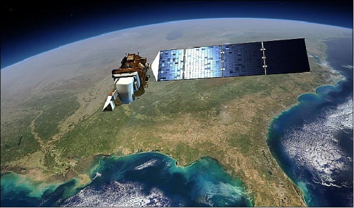
Mission - Third Party Missions

Landsat-8
Landsat-8 is an Earth-imaging satellite from USGS and NASA which launched in 2013. The Landsat programme provides a global archive of satellite imagery.
Document - General Reference
BIOMASS-Report-for-Mission-Selection-An-Earth-Explorer-to-observe-forest-biomass.pdf
The objective of the BIOMASS Mission is to determine the global distribution of forest biomass by reducing the uncertainty in the calculation of carbon stock and fluxes associated with the terrestrial biosphere.
Document - General Reference
Earth-from-Space-Middle-East.pdf
This brochure is a collection of ENVISAT ASAR and MERIS, PROBA, ERS-2, Landsat mosaics.
Document - General Reference
Earth-from-Space-Deserts.pdf
This brochure is a collection of Envisat MERIS, Envisat ASAR, Proba and Landsat mosaics of desert areas on our planet.
Document - General Reference
Earth-from-Space-Deltas-and-Lakes.pdf
This brochure is a collection of Envisat MERIS, Envisat ASAR, ERS, Proba and Landsat mosaics.