- All Categories (43)
- Data (5)
- News (5)
- Missions (5)
- Tools (2)
- Documents (26)
Data - Sample Data (Open)
IRS-P5 (Cartosat-1) Sample Data
Download free IRS-P5 (Cartosat-1) sample datasets to preview products available for this mission.
News - Events and Proceedings
Workshop celebrates end of long-running PROBA-1 satellite
In January, ESA will mark the end of its long-running CHRIS sensor onboard the PROBA-1 satellite in a special workshop.
News - Success Stories
New cross-calibration readies PROBA-1 data for climate research
While PROBA-1 has already exceeded expectations by suppling over 21 years of Earth observation hyperspectral data, recent cross-calibration activities are aiming to ensure the data will robustly serve long time-series research, even when the satellite ends operations.
Document - Data Access Information
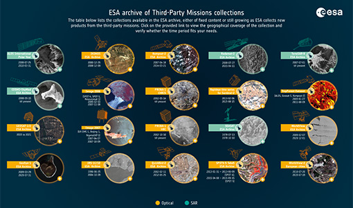
ESA-archive-third-party-mission-collections.pdf
Discover the ESA archive data collections offered for the Third Party Missions programme.
Tools - Catalogues
FedEO
FedEO is a data catalogue that provides a unique entry point to a number of scientific catalogues and services for, but not limited to, European and Canadian missions.
Tools - Catalogues
EO CAT
EO CAT is a data catalogue, offering a Next Generation Earth Observation system designed to manage end-user Earth Observation services.
News - Infographics
A summary of ESA Third Party Mission collections
A new summary is available, showcasing the ESA archives for Third Party Mission collections.
News - Infographics
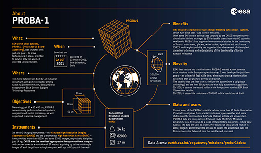
PROBA-1 - From technology demonstration to long-term Earth observation
Learn about ESA's PROBA-1 (Project for On-Board Autonomy) mission in our new infographic.
News - General News
Release of CHRIS PROBA-1 toolbox for SNAP
PROBA -1 continues to provide valuable hyperspectral data to the scientific community, and so the tools to handle this data have been incorporated into ESA’s SNAP multi-mission toolbox.
Data - EO Sign In Authentication (Open)
PROBA-1 HRC
The HRC Level 1A product is an image with a pixel resolution of 8m. The data are grey scale images, an image contains 1026 x 1026 pixels and covers an area of 25 km2. HRC data is supplied in BMP format. All PROBA-1 passes are systematically acquired according to the current acquisition plan, HRC data are processed every day to Level 1A and made available to ESA users. Spatial coverage: Check the spatial coverage of the collection on a map available on the Third Party Missions Dissemination Service.
Data - Project Proposal (Restrained)
IRS-1C/1D Full archive
The following products are available: PAN: Panchromatic, resolution 5 m, Coverage 70 km x 70 km, radiometrically and ortho (DN) corrected, LISS-III: Multi-spectral, resolution 25 m, Coverage 140 km x 140 km, radiometrically and ortho (DN) corrected (ortho delivered without Band 5) WiFS: Multi-spectral, resolution 180 m, Coverage 800 km x 800 km, radiometrically and ortho (DN) corrected. Sensor Type Resolution (m) Coverage (km x km) System or radiometrically corrected Ortho corrected (DN) Global archive PAN Panchromatic 5 70 x 70 X X 1996 – 2007 (IRS-1C) 1998 – 2009 (IRS-1D) LISS-III Multi-spectral 25 140 x 140 X X (without band 5) WiFS Multi-spectral 180 800 km x 800 km X X Note: Whether system corrected or radiometrically corrected products are available depends on sensor and processing centre For PAN and LISS-III ortho corrected: If unavailable, user has to supply ground control information and DEM in suitable quality For WiFS ortho corrected: service based on in house available ground control information and DEM.
Data - EO Sign In Authentication (Open)
IRS-1C/1D European coverage
IRS-1C/1D dataset is composed of products generated by the Indian Remote Sensing (IRS) Satellites 1C/1D PAN sensor. The products, acquired from 1996 to 2004 over Europe, are radiometrically and ortho corrected level 1 black and white images at 5 metre resolution and cover an area of up to 70 x 70 km. Sensor Type Resolution (m) Coverage (km x km) System or radiometrically corrected Ortho corrected (DN) Acquisition in Neustrelitz PAN Panchromatic 5 70 x 70 X X 1996 - 2004 IRS-1C/1D PAN data coverage of Europe acquired between 1996 to 1998. Copyright: 2015 GAF AG IRS-1C/1D PAN data coverage of Europe acquired between 1999 to 2001. Copyright: 2015 GAF AG IRS-1C/1D PAN data coverage of Europe acquired between 2002 to 2004. Copyright: 2015 GAF AG Spatial coverage: Check the spatial coverage of the collection on a map available on the Third Party Missions Dissemination Service.
Data - Project Proposal (Restrained)
CartoSat-1 archive and Euro-Maps 3D Digital Surface Model
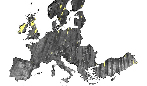
CartoSat-1 (also known as IRS-P5) archive products are available as PAN-Aft (backward), PAN-Fore (forward) and Stereo (PAN-Aft and PAN-Fore). Sensor Products Type Resolution (m) Coverage (km x km) System or radiometrically corrected Ortho corrected (DN) Neustralitz archive Global archive PAN PAN-Aft (backward) PAN-Fore (forward) Stereo (PAN-Aft+PAN-Fore) Panchromatic 2.5 27 x 27 X X 2007 - 2016 2005 - 2019 Note: Resolution 2.5 m. - Coverage 27 km x 27 km System or radiometrically corrected. For Ortho corrected products, if unavailable, user has to supply ground control information and DEM in suitable quality For Stereo ortho corrected: only one of the datasets will be ortho corrected. Euro-Maps 3D is a homogeneous, 5 m spaced digital surface model (DSM) semi-automatically derived from 2.5 m in-flight stereo data provided by IRS-P5 CartoSat-1 and developed in cooperation with the German Aerospace Center, DLR. The very detailed and accurate representation of the surface is achieved by using a sophisticated and well adapted algorithm implemented on the basis of the Semi-Global Matching approach. In addition, the final product includes detailed flanking information consisting of several pixel-based quality and traceability layers also including an ortho layer. Product Overview Post spacing 5 m Spatial reference system DD, UTM or other projections on WGS84 Height reference system EGM96 Absolute vertical accuracy LE90 5-10 m Absolute Horizontal Accuracy CE90 5-10 m Relative vertical accuracy LE90 2.5 m File format GeoTIFF, 16 bit Tiling 0.5° x 0.5° Ortho Layer Pixel Size 2.5 m The CartoSat-1 products and Euro-Maps 3D are available as part of the GAF Imagery products from the Indian missions: IRS-1C, IRS-1D, CartoSat-1 (IRS-P5), ResourceSat-1 (IRS-P6) and ResourceSat-2 (IRS-R2) missions. Euro-Maps 3D available data map
Mission - Third Party Missions
PROBA-1
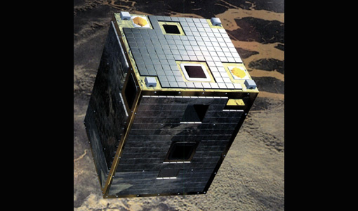
PROBA-1 is a technology demonstration satellite that later became an operational Earth observation mission.
Mission - Heritage Missions
IRS-1C and IRS-1D
The Indian Remote Sensing satellites IRS-1C and IRS-1D were identical Earth-imaging satellites operated by the Indian Space Research Organisation.
Document - Publication - Paper
Comparing Three Canopy Reflectance Models with Hyperspectral Multi-Angular Satellite Data
Studies that compare modelled reflectances with satellite-measured reflectances for different wavelengths and view angles are still rare. We compared model outputs from three different canopy reflectance models (SLC, FRT and INFORM) with satellite measured reflectances (Chris/PROBA).
Document - Publication - Paper
Mapping of chlorophyll and suspended particulate matter maps from CHRIS imagery of the Oostende ---
The image set created on 5 August 2003 by CHRIS/PROBA is analyzed to assess the feasibility of producing suspended particulate matter (SPM) and chlorophyll (CHL) maps.
Document - Proceedings
Hyperspectral Workshop 2010
Proceedings of the Hyperspectral Workshop 2010 held on 17-18 March 2010 in ESA-ESRIN, Frascati, Italy. This workshop was organised by the European Space Agency (ESA), the German Aerospace Center (DLR)/the German Research Center for Geosciences (GFZ) and the Italian Space Agency (ASI).
Document - General Reference
Overview of an Intelligent Sensorweb for Integrated Earth Sensing Project


