- All Categories (108)
- Data (30)
- News (30)
- Missions (4)
- Events (28)
- Tools (3)
- Campaigns (5)
- Documents (8)
News - General News

ESA's improved Earth system data records: what is in store for the future?
Fundamental Data Records (FDRs) are instrumental in advancing our understanding of Earth systems and for addressing societal challenges effectively. These long-term records contain uncertainty-quantified, calibrated and geo-located multi-instrument/multi-platform satellite sensor data spanning several decades to support climate-related applications.
Data - Sample Data (Open)
IRS-P6 (ResourceSat-1) Sample Data
Download free IRS-P6 (ResourceSat-1) sample datasets to preview products available for this mission.
News - Infographics
Showcasing the NovaSAR-1 radar satellite
Learn about the NovaSAR-1 mission in our new infographic.
News - Success Stories
Trailblazing ERS-2 mission enables climate change applications
As ESA’s ERS-2 satellite approaches Earth’s atmosphere for reentry, it’s time to reflect on the mission’s great achievements in powering climate-related applications.
News - Data Release news
New FLEX-related campaign datasets released
New datasets have been released for three campaigns, covering activities supporting the upcoming FLEX mission.
News - Announcement of Opportunity updates
ESA encourages S-band applications with NovaSAR-1 Announcement of Opportunity
ESA is offering possibilities to develop new applications in the S-band microwave frequency range, with a new Announcement of Opportunity for NovaSAR-1 data, via ESA’s Third Party Mission programme.
Document - Campaign Report

FLEXSense 2019 Final Report
This report summarises the FLEXSense 2019 campaign.
Campaign
FLEXSense 2019
The FLEXSense 2019 campaign activities were undertaken in Germany and Italy with the goal of providing a complete set of high-resolution experimental data, including all relevant elements required for the preparation of the FLEX satellite mission.
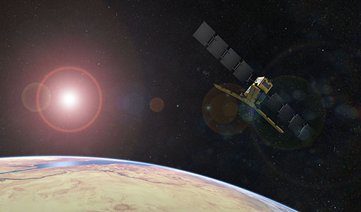
Mission - Third Party Missions
NovaSAR-1
Launched on 16 September 2018, NovaSAR-1 features an S-band synthetic aperture radar (SAR) instrument offering a variety of modes with different resolutions and swath widths.
Data - Announcement of Opportunity (Restrained)
Announcement of Opportunity for NovaSAR-1
ESA is launching an Announcement of Opportunity for the international scientific community to access data from the NovaSAR-1 mission for science and EO-based applications development.
Data - Project Proposal (Restrained)
NovaSAR-1 new tasking
NovaSAR-1 new acquisition data are available in two baseline acquisition modes: Stripmap – provides the highest resolution of 6 metres with up to 20 km swath selected from a 150 km field of regard, available in single polarisation. ScanSAR – has a 20 - 30 metre resolution and up to 150 km swath. Available in single polarisation. Within each of the baseline modes there are a variety of mode options that vary according to ground range resolution, incidence angles, swath width and the number of looks: Acquisition Mode Polarisation Resolution (m) Swath Width (km) Incidence Angles Number of Looks Stripmap Single: HH 6 20 16.0 – 25.38° 3 (1 range, 3 azimuth) 13 – 20 21.29 – 31.2° Single: VV 6 20 16.0 – 25.38° 3 (1 range, 3 azimuth) 13 – 20 21.29 – 31.2° ScanSAR Single: HH 20 100 15.0 - 24.66° 4 (2 range, 2 azimuth) 50 24.51 - 28.94° Single: VV 20 100 15.0 – 24.66° 4 (2 range, 2 azimuth) 50 24.51 - 28.94° Single: HH 30 150 11.29 – 25.93° 4 (2 range, 2 azimuth) 55 27.35 - 32.01° Single: VV 30 150 11.29 – 25.93° 4 (2 range, 2 azimuth) 55 27.35 - 32.01° NovaSAR-1 data are provided as a Level 2 (ARD) product as standard, but the accompanying Level 1 data may also be requested. Level 1 – delivered as reconstructed, unprocessed instrument data at full resolution. Level 2 (ARD) – delivered as a processed product with applied radiometric and geometric corrections i.e. orthorectification and spatial registration: Geocoded Ellipsoid Corrected (GEC) – Maritime and ocean applications Geocoded Terrain Corrected (GTC) – Land applications and change detection Where available, associated automatic identification system (AIS) data may be requested alongside the NovaSAR-1 data products.
News - Operational News

Update for the SMOS Near Real Time Sea Surface Wind Speed Processor configuration
An updated configuration of the SMOS Near Real Time Sea Surface Wind Speed Processor was deployed at the IFREMER and ESA operational ground segment on 4th December 2023.
Data - EO Sign In Authentication (Open)
MOS-1/1B ESA Orthorectified Map-oriented Products [MES_GEC_1P]
The ESA Orthorectified Map-oriented (Level 1) Products collection is composed of MOS-1/1B MESSR (Multi-spectral Electronic Self-Scanning Radiometer) data products generated as part of the MOS Bulk Processing Campaign using the MOS Processor v3.02. The products are available in GeoTIFF format and disseminated within EO-SIP packaging. Please refer to the MOS Product Format Specification for further details. The collection consists of data products of the following type: MES_GEC_1P: Geocoded Ellipsoid GCP Corrected Level 1 MOS-1/1B MESSR products which are the default products generated by the MOS MESSR processor in all cases (where possible), with usage of the latest set of Landsat improved GCP (Ground Control Points). These are orthorectified map-oriented products, corresponding to the old MOS-1/1B MES_ORT_1P products with geolocation improvements. MESSR Instrument Characteristics Band Wavelength Range (nm) Spatial Resolution (m) Swath Width (km) 1 (VIS) 510 – 690 50 100 2 (VIS) 610 – 690 50 100 3 (NIR) 720 – 800 50 100 4 (NIR) 800 – 1100 50 100
Data - EO Sign In Authentication (Open)
MOS-1/1B ESA System Corrected Map-oriented Products [MES_GES_1P]
The ESA System Corrected Map-oriented (Level 1) Products collection is composed of MOS-1/1B MESSR (Multi-spectral Electronic Self-Scanning Radiometer) data products generated as part of the MOS Bulk Processing Campaign using the MOS Processor v3.02. The products are available in GeoTIFF format and disseminated within EO-SIP packaging. Please refer to the MOS Product Format Specification for further details. The collection consists of data products of the following type: MES_GES_1P: Geocoded Ellipsoid System Corrected Level 1 MOS-1/1B MESSR products as generated by the MOS MESSR processor where the generation of MES_GEC_1P products is not possible. These replace the old MES_SYC_1P products. MESSR Instrument Characteristics Band Wavelength Range (nm) Spatial Resolution (m) Swath Width (km) 1 (VIS) 510 – 690 50 100 2 (VIS) 610 – 690 50 100 3 (NIR) 720 – 800 50 100 4 (NIR) 800 – 1100 50 100
Data - EO Sign In Authentication (Open)
MOS-1/1B ESA System Corrected VTIR Products [VTI_SYC_1P]
The ESA System Corrected (Level 1) MOS-1/1B VTIR Products collection is composed of MOS-1/1B VTIR (Visible and Thermal Infrared Radiometer) data products generated as part of the MOS Bulk Processing Campaign using the MOS Processor v3.02. The products are available in GeoTIFF format and disseminated within EO-SIP packaging. Please refer to the MOS Product Format Specification for further details. The collection consists of data products of the following type: VTI_SYC_1P: System corrected Level 1 MOS-1/1B VTIR products in EO-SIP format. VTIR Instrument Characteristics Band Wavelength Range (µm) Spatial Resolution (km) Swath Width (km) 1 (VIS) 0.5 – 0.7 0.9 1500 2 (TIR) 6.0 – 7.0 2.7 1500 3 (TIR) 10.5 – 11.5 2.7 1500 4 (TIR) 11.5 – 12.5 2.7 1500
Event - Workshop

PROBA-1 CHRIS End of Mission Workshop
The PROBA-1 CHRIS End of Mission Workshop will take place from 18-19 January 2024 in Ghent, Belgium.
News - General News
SMOS Tools updates
Updates for two SMOS tools have been released, offering new features and improvements.
News - Spotlight on EO community

An overview of the SMOS mission
In this video, Klaus Scipal - Biomass and SMOS Mission Manager - talks about ESA's Soil Moisture and Ocean Salinity mission.
News - Success Stories
ESA missions help to reveal worldwide lake water loss trend
Climate change, human consumption and sedimentation are depleting more than half of the world’s biggest lakes of water, according to a ground-breaking analysis that drew on three decades of satellite data.
News - Success Stories
SMOS data reveal ecosystems' resistance to drought
Climate change is rapidly altering the world’s ecosystems, causing extreme weather conditions, such as droughts, to become increasingly frequent. Understanding the factors that contribute to ecosystem resilience to extreme events is vital to develop more effective strategies for climate adaptation and mitigation.