- All Categories (33)
- Data (8)
- News (9)
- Missions (1)
- Events (11)
- Activities (4)
News - Infographics
The International Charter - Providing satellite data to support disaster response worldwide
Learn about the International Charter Space and Major Disasters in this new infographic.
News - Events and Proceedings
Scientists to showcase value of Earth observation data at EGU
Remote sensing scientists are getting ready to present innovative and exciting applications of satellite data at the European Geosciences Union general assembly which will take place from 24 to 28 April in Vienna, Austria.
News - Announcement of Opportunity updates
Researchers called to explore new applications of SAOCOM data
ESA has invited Earth observation experts to devise and propose innovative applications for data delivered by Argentinian remote sensing constellation SAOCOM.
Event - Workshop
POLinSAR 2019
ESA organised POLinSAR 2019, the 9th International Workshop on Science and Applications of SAR Polarimetry and Polarimetric Interferometry.
Event - Workshop
POLinSAR 2013
The objectives of the PolInSAR 2013 workshop were to present the latest studies and results of SAR polarimetry and polarimetric interferometry.
Event - Workshop
POLinSAR 2009
The 2009 workshop focused on theory and methods in the fields of SAR Polarimetry and Polarimetric Interferometry
Event - Workshop
POLinSAR 2007
The POLinSAR 2007 workshop was open to ESA Principal Investigators and co-investigators, scientists and students working in the field of SAR Polarimetry and Polarimetric Interferometry, and to representatives from national, European and international space agencies and value adding industry.
News - Infographics
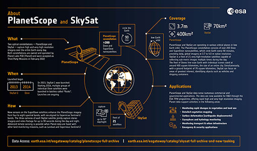
PlanetScope and SkySat - The high-resolution nanosatellite constellation
Find out more about the PlanetScope and SkySat missions in our new infographic.
Mission - Heritage Missions
NOAA POES
NOAA's AVHRR sensor is carried on the POES mission, a constellation of polar orbiting weather satellites.
News - Success Stories
Magnetic magic: 10 reasons to be excited about Swarm
In November 2023, Swarm celebrated an impressive ten years in orbit. In that time, ESA’s magnetic mission has honed in on all sorts of mysteries - from tussling magnetic blobs to animal migration.
Activity - General activities
International Charter Space and Major Disasters
Learn about the International Charter Space and Major Disasters, which ESA participate in disaster monitoring.
Event - Workshop
Insurance Industry Workshop on Earth Observation
This ESA workshop examined the potential value of satellite Earth Observation data to the insurance industry.
News - Success Stories
Gravity Field Models from Swarm data
In addition to its geomagnetic objectives, GPS receivers onboard Swarm can and have already been exploited to measure temporal variations in Earth's global gravity field.
Event - Workshop
Fringe 2007 Workshop
Fringe 2007 was the third International Workshop on Envisat ASAR interferometry and fifth International Workshop on ERS SAR Interferometry.
Event - Workshop
Fringe 2003 Workshop
The third ESA International Workshop on ERS SAR Interferometry and its first Workshop on ASAR interferometry: Advances in SAR interferometry from ERS and Envisat missions.
Event - Workshop
Fringe 1996 Workshop
The workshop on ERS SAR Interferometry was open to scientists and students working in the field of Synthetic Aperture Radar (SAR) interferometry and its applications.
News - Infographics
Focusing on Envisat MERIS Full Resolution Level-2 data
ESA's Envisat mission continued and expanded upon the legacy of its predecessors, the ERS (European Remote Sensing) satellites. Operating between 2002 and 2012, the satellite's 10 instruments acquired a decade of data for many applications.
Data - Fast Registration with approval (Restrained)
ERS-1/2 ATSR Gridded Surface Temperature [AT1/AT2_NR__2P]
The Gridded Surface Temperature (GST) Product is the Level 2 full resolution geophysical product. The product contains gridded sea-surface temperature images using both nadir and dual view retrieval algorithms. The product includes pixel latitude/longitude positions, X/Y offset and the results of the cloud-clearing/land-flagging. It contains a single measurement data set the content of which is switchable, that is to say, the content of each pixel field will depend on the surface type. Specifically, the contents of the data fields will depend on the setting of the forward and nadir cloud flags and the land flag. The 3rd reprocessing of ATSR data was performed in 2013; the processing updates that have been put in place and the scientific improvements are outlined in full in the User Summary Note for the Third ERS ATSR Reprocessing.
Data - Fast Registration with approval (Restrained)
ERS-1/2 ATSR Gridded Brightness Temperature/Reflectance [AT1/AT2_TOA_1P]
The Gridded Brightness Temperature/Reflectance (GBTR) product contains top of atmosphere (TOA) brightness temperature (BT) values for the infra-red channels and reflectance values for the visible channels. Values for each channel and for the nadir and forward views occupy separate measurement data sets. Additional MDS contain cloud and land/sea flags and confidence flags for each image pixel. The 3rd reprocessing of ATSR data was performed in 2013; the processing updates that have been put in place and the scientific improvements are outlined in full in the User Summary Note for the Third ERS ATSR Reprocessing.
Data - Fast Registration with approval (Restrained)
ERS-1/2 ATSR Averaged Surface Temperature [AT1/AT2_AR__2P]
The Averaged Surface Temperature Product (AST) contains averaged geophysical data at two different resolutions, and with respect to two different averaging schemes: measurement data sets at resolutions of 0.5 by 0.5 degrees and 10 by 10 arcmin with respect to a latitude/longitude grid; other data sets contain data averaged over equal area cells of 50 by 50 km and 17 by 17 km aligned with the satellite ground track. Both top-of-atmosphere and surface data sets are provided. The surface temperature data sets provide, for sea cells, nadir and dual view sea surface temperatures, and for land cells, land surface temperature (currently 11 micron BT) and NDVI. Cloud data is also included. No ADS are included in the AST product; auxiliary data is contained within the MDS. The data sets of the AST product are arranged by surface type and resolution. The 3rd reprocessing of ATSR data was performed in 2013; the processing updates that have been put in place and the scientific improvements are outlined in full in the User Summary Note for the Third ERS ATSR Reprocessing.

