- Activities
- International Charter Space an...
International Charter Space and Major Disasters
Overview
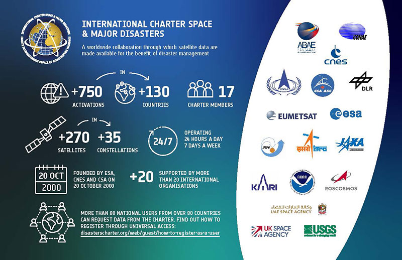
On 20 October 2000, the European Space Agency (ESA), the French national space agency (Centre National d’etudes Spatiales) and the Canadian Space Agency (CSA) founded the International Charter on Space and Major Disasters. The three agencies pledged to provide data from their satellites following natural or technological disasters around the world, at no cost to end users, with the goal to aid emergency response on the ground.
Since that day, membership in the Charter has grown to 17 space agencies and space system operators, who continue to commit their time and satellite data to help disaster relief organisations obtain an overview of disaster areas and where to direct rescue and recovery operations.
In the event of a disaster, Authorised Users may submit a request to the Charter for help. The Charter members activate the Charter after assessing the feasibility of the request, and satellites are tasked to acquire data over the affected location. Data is provided for rapid mapping purposes during the immediate aftermath, typically up to one month after a disaster takes place.
With the combined resources of the Charter’s virtual satellite constellation, many different types of disaster are monitored, including floods, storms, earthquakes, and volcanoes. The Charter is most commonly activated for floods and storms.
In over 20 years of operation, the International Charter has been activated more than 750 times to provide satellite data for disasters in more than 130 countries.
"Satellite data to support disaster response worldwide"
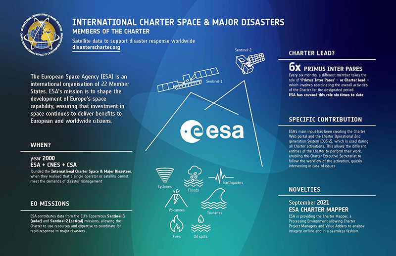
As one of the founding members of the Charter, ESA has been involved since its inception. Today, ESA contributes data from the Copernicus Sentinel-1 and 2 missions, which acquire radar and optical data, respectively, both of which provide valuable insights in the aftermath of a disaster.
Historically, ESA provided data from the ERS and Envisat missions until Envisat ended operations in 2012. As ESA’s first Earth observing satellites, these missions pioneered use of satellite data for many applications, including disaster monitoring. The Sentinel missions provide continuity for the ERS and Envisat datasets.
ESA were also responsible for creating the website for the Charter, and the Charter Operational System (COS-2). COS-2 is used by the members of the Charter and supporting roles to manage the operations of activations. In September 2021, ESA developed the Charter Mapper, a processing environment that enables Charter Project Managers and Value Adders to analyse the large amount of imagery acquired through the Charter in an online platform.
Learn more about the International Charter: