- All Categories (55)
- Data (23)
- News (9)
- Missions (3)
- Events (12)
- Tools (2)
- Activities (1)
- Campaigns (2)
- Documents (3)
Data - EO Sign In Authentication (Open)
Ocean Waves Thematic Data Product [ALT_TDP_WA]
This is the Ocean Waves Thematic Data Product (TDP) V1 resulting from the ESA FDR4ALT project and containing Significant Wave Height estimates for the ERS-1, ERS-2 and Envisat missions. Compared to existing datasets, the Ocean Waves TDP demonstrates notable improvements in several aspects: Great improvements for Envisat due to noise reduction from Adaptive retracker and High-Frequency Adjustment (HFA) All variables are given at 5 Hz The FDR4ALT products are available in NetCDF format. Free standard tools for reading NetCDF data can be used. Information for expert altimetry users is also available in a dedicated NetCDF group within the products. Please consult the FDR4ALT Product User Guide before using the data. The FDR4ALT datasets represent the new reference data for the ERS/Envisat altimetry missions, superseding any previous mission data. Users are strongly encouraged to make use of these datasets for optimal results.
Document - Product Handbook

SAR Tropical Atmospheric Phenomena Handbook
ERS SAR Tropical Atmospheric Phenomena Handbook.
News - Success Stories
New CryoSat data to boost understanding of the oceans
A new CryoSat sea level anomaly product designed to enable ocean science and the development of operational marine applications has been released.
News - Thematic area articles
Tracking the world’s forests from space
As human activities continue to threaten the planet’s forests, data delivered by satellites are boosting global efforts to conserve these crucial natural resources.
News - Spotlight on EO community
An overview of the Biomass mission
In this video, Klaus Scipal - Biomass and SMOS Mission Manager - talks about ESA's upcoming Biomass mission.
News - Infographics

An overview of ESA's Biomass Earth Explorer satellite
Learn about ESA's upcoming Biomass mission, which is dedicated to gathering information about the global distribution of forest biomass, in our latest infographic.
News - Thematic area articles

How satellite data help to shape society
Data from ESA’s Earth observation archives are improving understanding of the interactions between human activities and the environment, helping to power green economic development and boosting prosperity in Europe and beyond.
Event - Training

EO Summer School 4
ESA's series of summer schools, on Monitoring of the Earth System, aims to promote the exploitation of Earth observation data.
Activity - Projects

Contribution of Swarm data to the prompt detection of Tsunamis and other natural hazards
The main objective of COSTO (Contribution of Swarm data to the prompt detection of Tsunamis and other natural hazards) project is to better characterise, understand and discover coupling processes and interactions.
News - Success Stories

10 years of Envisat data help to illuminate ocean processes
A decade after Envisat beamed its final image to the planet, the pioneering ESA mission is continuing to foster improved understanding of Earth’s systems.
Event - Workshop

2007 International Geohazards Week
The ESA event was part of the United Nations International Year of Planet Earth, to increase awareness of the importance of Earth sciences for the advancement of sustainable development.
Event - Workshop
SEASAR 2006
ESA organised it's first SAR oceanography workshop, SEASAR 2006, entitled "Advances in SAR Oceanography from Envisat and ERS missions"
Event - Workshop
Coastal and Marine Applications of SAR Workshop 2003
The second in the Coastal and Marine Applications of SAR Workshop series covered a range of topics on applications of synthetic aperture radar (SAR) in coastal and marine environments.
News - Infographics
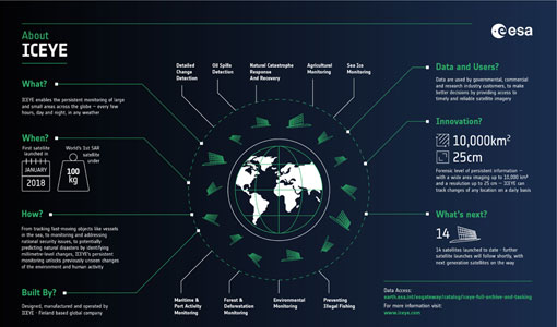
ICEYE – A persistent monitoring SAR constellation
Learn more about the ICEYE mission, a constellation of SAR satellites and part of ESA's Third Party Missions programme, in our latest infographic.
Event - Workshop
SEASAR 2008
The "Advances in SAR Oceanography from Envisat and ERS missions" was a thematic workshop on SAR remote sensing techniques for oceanography.
Event - Training
2nd Advanced Training Course on Ocean Remote Sensing 2009
This advanced training course focused on ocean remote sensing theory and applications.
Tools - Apps

Heritage Missions app for iOS
Download the Heritage Missions application to discover what the missions were about, how it worked and what the elements of the space and ground segment that make these missions unique.
News - Data Release news

ESA's (A)SAR dissemination service enhanced with Envisat ASAR MR L1 data
With integration of four additional Envisat ASAR Level 1 collections, ESA is now providing access to the complete Envisat and ERS (A)SAR imagery data archive via the ESA (A)SAR Online Dissemination service.
News - Data Release news

New ERS-2 GOME Level 1 v5.1 dataset available online
A new GOME Level 1b dataset has been generated for the 16-year mission period bringing relevant quality improvements for the revised calibration approach, compensating aging and instrument degradation, and provide enhanced accessibility.
Data - Project Proposal (Restrained)

SPOT-6 to 7 full archive and tasking
The SPOT 6 and 7 satellites ensure data continuity with the no longer operational SPOT 5 satellite and provide an archive of very high resolution optical acquisition as well as the possibility to task the satellites for new acquisitions. Following the completion of the SPOT 7 mission in March 2023, new acquisition tasking is only available for the SPOT 6 satellite. The ortho-products are automatically generated by the SPOT 6 and 7 ground segment, based on SRTM database or Reference3D when available. The projection available for SPOT 6 and 7 ortho-products is UTM, datum WGS84. Bands combinations: Pansharpened: colour image at 1.5 m resolution Bundle: 1.5 m panchromatic image and 6 m multispectral image. Geometric processing levels: Primary: The Primary product is the processing level closest to the natural image acquired by the sensor. This product restores perfect collection conditions: the sensor is placed in rectilinear geometry, and the image is clear of all radiometric distortion. Standard Ortho: The Ortho product is a georeferenced image in Earth geometry, corrected from acquisition and terrain off-nadir effects. Tailored ortho: Aside from the Standard Ortho product, when different specifications are needed, a custom orthorectification, with a more precise 3D model provided by the client or acquired for the purpose, can be provided on demand. As per ESA policy, very high-resolution imagery of conflict areas cannot be provided.