- All Categories (14)
- Data (1)
- Missions (2)
- Events (3)
- Tools (2)
- Activities (3)
- Documents (3)
Event - Meeting
VH-RODA and CEOS SAR workshop
The workshop provided an open forum for the presentation and discussion of current status and future developments related
Activity - Quality
EDAP
The following missions are currently being considered as part of the Automatic Identification System (AIS) and Radio Frequency
Activity - Quality
SLAP
Currently, in excess of 701,000 Level 1 TM and 84,000 Level 1 ETM+ products have been reprocessed and released under the
Event - Training
EO Summer School 3
In line with observations it shows anti-cyclonically rotating surface currents and cyclonically rotating bottom currents.
Tools - Visualisation
HEDAVI
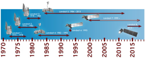
ESA’s Heritage EO data currently cover more than 30 years of observations and enable the analysis of spatio-temporal dynamics
Document - Product Document
LANDSAT_Products_Description_Document.pdf
This document acts as a User Guide to the Landsat MSS, TM and ETM+ archives, focussing more specifically on the Landsat TM and ETM+ products from the Kiruna, Maspalomas and Matera archives (including from the Matera, Fucino, Neustralitz, O’Higgins, Malindi, Libreville and Bishkek ground stations) that have been generated as part of the ESA archive bulk-reprocessing project.
Event - Workshop
Fringe 2007 Workshop
Is it possible to uniquely identify a spatially correlated interferometric phase error due to ionosphere using current sensors
Data - Announcement of Opportunity (Restrained)
Closed ESA announcement of opportunities
See currently open announcements of opportunity.
Mission - Third Party Missions
Multi Spectral Scanner (MSS) Processor Releases
GCP displacement B TM radiometric calibration Update to radiometric calibration strategy for TM reflective bands (Dark Current
Mission - Third Party Missions
Thematic Mapper (TM) Processor Releases
GCP displacement B TM radiometric calibration Update to radiometric calibration strategy for TM reflective bands (Dark Current
Activity - General activities
GSCB and LTDP
Envisat data are used in many fields of Earth science, including atmospheric pollution, fire extent, sea ice motion, ocean currents


