- SAOCOM
- Data
SAOCOM Data
Data Collections
The following data collections are available:
- SAOCOM Europe data collection: On the basis of an agreement with ASI, access to the data is handled externally through ASI's SAOCOM Data Hub. The collection offers products acquired inside the ASI Zone of Exclusivity.
- Announcement of opportunity for SAOCOM: On the basis of the recent agreement between ESA and CONAE, the PUMAS initiative, access to the data is provided upon the successful evaluation by ESA and CONAE of proposals stating the proposed use for the data. The collection offers products acquired outside of the ASI Zone of Exclusivity.
The ASI Zone of Exclusivity is a region covering Europe and the Mediterranean. ASI maintains exclusive distribution rights for SAOCOM data acquired over this area.
SAOCOM products are organised in the following levels:
| Product Name | Level | Description |
| Single Look Complex (SLC) | Level-1A | Complex data in slant range, radiometrically calibrated with no geometric corections. Generated from Level-0 products |
| Detected Image (DI) | Level-1B | Data projected to ground range, radiometrically calibrated and georeferenced. Generated from Level-0 products |
| Ground Elipsoid Corrected (GEC) | Level-1C | Radiometrically calibrated, geocoded and georeferenced exploiting elipsoid. Generated Level-0 products |
| Ground Terrain Corrected(GTC) | Level-1D | Radiometrically calibrated, geocoded and georeferenced exploiting topography. Generated Level-0 products |
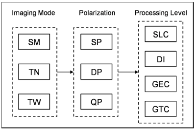
The following figure shows the family tree for the SAOCOM Level 1 products, characterised by Stripmap, TOPSAR Narrow and TOPSAR Wide imaging modes with Single, Dual and Quad Polarization.
| Beam Mode | Beam Position | Minimum Incidence Angle Range | Nominal Spatial Resolution | Minimum Swath Width (ground range) [km] | Nominal Azimuth Length [km] | Nominal Equivalent Number of Looks | |||
| L1A products | L1B, L1C, and L1D products | L1A (SLC) | L1B (DI) L1C (GEC) L1D (GTC) | ||||||
| Near Range [°] | Far Range [°] | Ground Range x Azimuth (m x m) | Ground Range x Azimuth (m x m) | ||||||
| Stripmap Single Pol and Dual Pol | S1 | 20.7 | 25.0 | 10 x 5 | 10 x 10 | 49.7 | 74.1 | 1 | 2 |
| S2 | 24.9 | 29.2 | 52.3 | ||||||
| S3 | 29.1 | 33.8 | 61.4 | ||||||
| S4 | 33.7 | 38.3 | 65.7 | ||||||
| S5 | 38.2 | 41.3 | 49.1 | ||||||
| S6 | 41.3 | 44.5 | 55.6 | ||||||
| S7 | 44.6 | 47.1 | 48.0 | ||||||
| S8 | 47.2 | 48.7 | 31.9 | ||||||
| S9 | 48.8 | 50.2 | 31.1 | ||||||
| Stripmap Quad Pol | S1 | 17.6 | 19.5 | 10 x 6 | 10 x 10 | 21.9 | 74.1 | 1 | 2 |
| S2 | 19.5 | 21.5 | 22.0 | ||||||
| S3 | 21.4 | 23.3 | 21.0 | ||||||
| S4 | 23.2 | 25.4 | 25.4 | ||||||
| S5 | 25.3 | 27.3 | 23.4 | ||||||
| S6 | 27.2 | 29.6 | 29.4 | ||||||
| S7 | 29.6 | 31.2 | 20.9 | ||||||
| S8 | 31.2 | 33.0 | 25.1 | ||||||
| S9 | 33.0 | 34.6 | 22.1 | ||||||
| S10 | 34.6 | 36.5 | 14.2 | ||||||
| TOPSAR Narrow Single Pol and Dual Pol | TNA | 24.9 | 38.3 | 10 x 30 | 30 x 30 | 176.3 | 222.3 | 1 | 3 |
| TNB | 38.2 | 47.1 | 150.2 | ||||||
| TOPSAR Narrow Quad Pol | TNA | 17.6 | 27.2 | 10 x 50 | 50 x 30 | 109.9 | 222.3 | 1 | 5 |
| TNB | 27.3 | 35.5 | 108.8 | ||||||
| TOPSAR Wide Single Pol and Dual Pol | TW | 24.9 | 48.7 | 10 x 50 | 50 x 50 | 353.7 | 444.6 | 1 | 5 |
| TOPSAR Wide Quad Pol | TW | 17.6 | 35.5 | 10 x 100 | 100 x 100 | 218.1 | 444.6 | 1 | 10 |
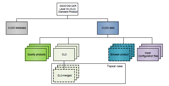
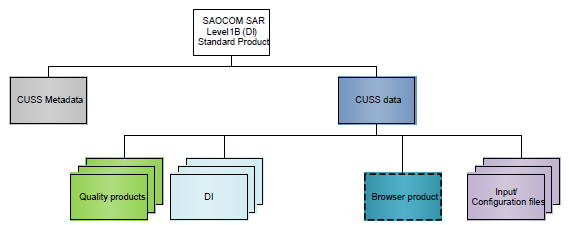
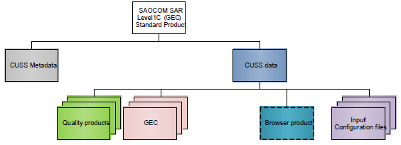
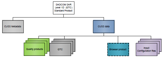
Products are stored in a CUSS (CONAE User Ground Segment Service) structure containing metadata in XML format and data in zip file. The content of the CUSS data file depends on the level 1 data type. There are four different standard products (Level 1A, 1B, 1C and 1D). Each product contains a variable number of files depending on the acquisition mode and polarizations.
The data consists of the scientific raster data in geoTIFF format coupled with a corresponding annotation file in XML format, plus a browser product in PNG and input and configuration files used to process the data. The structure for the four levels of product is reported in the following figures.