 Volcanoes Overview
The devastating consequences of volcanic eruptions are an obvious concern, and so volcanic activity is the object of constant study and analysis. Authorities often need data over volcanic areas, not only to monitor eruptions, but also to produce maps and thematic diagrams predicting the potential risk to the surrounding environment. Remote sensing data, which can provide an overview of large volcanic areas in a single frame, is used to detect lithological differences, vegetation changes, altimetric variations, and the extent of urban development in endangered areas. Volcanoes are mainly studied with optical data from instruments like AATSR and MERIS onboard Envisat, so that the same ground target can be examined in different spectral bands, ranging from visible to far infrared. Radar data from instruments like SAR make a unique contribution when altimetric change must be detected, or when volcanic eruptions cause phenomena that can be monitored by radar sensors like lava flow, ground fissures, earthquakes, mud slides, floods, etc.
Latest events
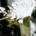
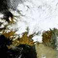
Eyjafjallajokull - Iceland, April 2010The volcano on the Eyjafjallajokull glacier in southern Iceland erupted just after midnight on Wednesday. Smoke from the top crater stacked more than 6,000 metres into the sky, meteorologists said. 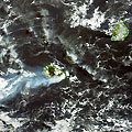
Piton de la Fournaise - La Reunion, April 2007The Director of the Observatory of Volcanology agency described the exceptional volcanic activity of the Piton de la Fournaise as “the eruption of the century”. The volcano erupted between 30 - 31 March 2007 and the eruption continued for another ten days.
Volcanoes
|
||||||||||||||||||||||||||||||||||||||||||||||