 Browse SAR Events by Year
20 Years of SAR
Browse SAR Events by Year
20 Years of SAR
Results: 160
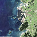
Saemangeum Dam - South KoreaThis series of images from the ERS-1/2, Envisat and Landsat satellites features Saemangeum Dam on the coast of the Yellow Sea in South Korea. The images follow the development of the area from 1987 to 2013. 
Dubai grows on the seaDubai is a city in the United Arab Emirates, located within the emirate. The emirate of Dubai is located on the southeast coast of the Persian Gulf and is one of the seven emirates that make up the country. It has the largest population in the UAE (2,106,177) and the second-largest land territory by area (4,114 km2) after Abu Dhabi, the national capital. 
Kansai and Kobe International Airport (Osaka Bay, Japan)Kansai International Airport is located on an artificial island in the middle of Osaka Bay, 38 km southwest of Osaka Station, located within three municipalities, including Izumisano (north), Sennan (south) and Tajiri (central) in Osaka Prefecture, Japan. 
Kumasi, Ashanti Region (Ghana)Kumasi is the capital city of the Ashanti region, a very important and historical centre for Ghana. Kumasi is located near Lake Bosumtwi, in a rainforest region, and is the commercial, industrial and cultural capital of Asanteman. Kumasi is approximately 480 km north of the Equator and 60 km north of the Gulf of Guinea. Kumasi is alternatively known as "The Garden City" because of its many beautiful species of flowers and plants. 
Hong Kong International AirportHong Kong International Airport is the main airport in Hong Kong. It is colloquially known as Chek Lap Kok Airport, being built on the island of Chek Lap Kok by land reclamation, and also to distinguish it from its predecessor, the closed Kai Tak Airport. 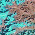
Lhonak Glacier (Sikkim Region, India)This series of images from the ERS and Envisat satellites, as well as Landsat 5 and 7, and ALOS, show a glacial lake that has formed atop the Himalayas in India. 
Athabasca Oil Sands (Alberta State, Canada)The Athabasca Oil Sands are large deposits of bitumen, or extremely heavy crude oil, located in north-eastern Alberta, Canada roughly cantered around the boomtown of Fort McMurray. These oil sands, hosted in the McMurray Formation, consist of a mixture of crude bitumen (a semi-solid form of crude oil), silica sand, clay minerals, and water. 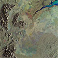
Global Deforestation 2012This series of images acquired by the ERS and Envisat satellites highlights deforestation as seen across the globe over the past twenty years. 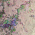
Cameroon Rainforest DeforestationThe rain forests in the Gulf of Guinea in Cameroon and Nigeria are a so-called hotspot of biodiversity. They house not only one of the oldest woodlands of the Earth but also a unique plant world: 620 species of trees and bushes, 500 kinds of herbs and lianas occur in the 1200 km² Korup National Park. Rare drills and chimpanzees live in the region, as well as forest elephants, gorillas and leopards. Many animal and plant species can be seen only here and nowhere else in the world. 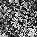
Bolivia Rainforest Deforestation 2012Forests in lowland Bolivia suffer from severe deforestation caused by different types of agents and land use activities. Three major proximate causes of deforestation have been identified. The largest share of deforestation is attributable to the expansion of mechanised agriculture, followed by cattle ranching and small-scale agriculture. 
New Orleans - Looking back on the impact of Hurricane KatrinaHurricane Katrina slammed into New Orleans on 29 August 2005, bringing death, destruction and despair. Entire neighbourhoods were wiped out, about 80 percent of the city was underwater and 1,800 people were killed. Over the last seven years, billions of dollars have been spent on rebuilding the city and revamping the levee system, yet the landscape has been altered forever. 
Guatemala Rainforest Deforestation 2012These images show different areas of the Guatemala rainforest ecoregions (Petén and Alta Verapaz). The images were created by merging separate SAR images from the Envisat and ERS-1 and 2 satellites, acquired at different dates during the missions. Guatemala has one of the most extensive and diverse forest systems in Central America. 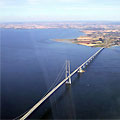
Storebalt Bridge (Denmark)This series of images from ESA's Envisat and ERS-2 satellites, shows the building phases of the Storebælt Bridge (Denmark). The bridge, which crosses the Storebælt (Great Belt) strait, was built to join the island of Fyn with the island of Sjælland and connects the east and west parts of Denmark. 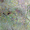
Mexico deforestation (Tabasco region)This composite radar multi-layer image was created by merging three separate images from ESA's ERS-2 and Envisat satellites, acquired at different dates during the missions. The image shows a large area of deforestation in the Tabasco Region of Mexico. 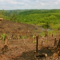
Riau Province Deforestation (Sumatra Island, Indonesia)These images show an area of deforestation in Riau Province, located on the east coast of Sumatra Island (Indonesia). These images were created by merging Envisat and ERS-2 satellite SAR images, acquired at different times during the missions. 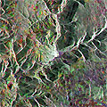
Millau Viaduct (Massif, Central France)This series of Envisat and ERS images feature the Millau Viaduct in central France, which holds the record (as of 2012) as being the tallest bridge in the world. 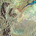
Borneo Deforestation 2012Borneo is one of the largest islands in the world, only Greenland and New Guinea have a greater land mass. The images featured in this article showcase Sabah State which is located in the northern part of the island. 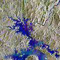
Serra de Mesa Dam, BrazilThis image, created with a merge of ERS-2 and Envisat satellite images, shows the Serra da Mesa Dam, in Brazil. The Serra da Mesa Dam was built to serve a hydroelectric power plant and forms the largest reservoir in Brazil. Construction of the dam and power station began in 1986, and on 24 October 1996 the dam began to inundate with water from the Tocantins River. 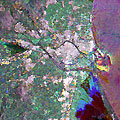
Valencia, SpainThis multi-temporal image, acquired over the city of Valencia (one of the largest cities in Spain), shows the urban development over a period of seven years along the Tura River. The image is a result of a merge of three separate acquisitions performed by the Envisat satellite (07 Aug 2010 in red, 18 Oct 2003 in green) and by ERS-2 (04 Nov 2011 in blue). 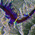
Three Gorges Dam, ChinaThis multi-temporal image, created by merging three separate images acquired by the Envisat and ERS-2 satellites, shows the Three Gorges Dam. It is a hydroelectric dam built along the Yangtze River near the town of Sandouping, located in the Yiling District of Yichang, in Hubei province, China. |
||