 Environmental Hazards
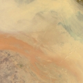
Satellite data has increasingly played a vital role in monitoring and responding to natural disasters and environmental hazards. Providing an overview of a developing situation or its aftermath from orbit, this data is very useful for forecasting a hazard or helping to coordinate relief. Examples of this can be seen in the Natural Disasters section of this website, featuring ESA imagery made available for major disasters. The Environmental Hazards section features other hazards that do not fit under those categories, such as sandstorms or heavy snow.
Latest Environmental Hazard Events
Results: 27
Fires in Majella National Park, Italy14 September 2017 - Wildfires have been burning in Majella National Park, Italy, since 20 August. Sentinel-2 was used to view the situation before and after the fires started, using false colour imagery to show the area affected by the fires. 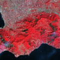
Amalfi Coast fires in Italy31 August 2017 - Wildfires continue to burn on the Amalfi coast in Italy, affecting a large area for two months now. These Sentinel-2 and Landsat 8 image comparisons provide an overview of the current situation. 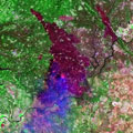
Monitoring the fires in Portugal31 July 2017 - More than 2000 firefighters continue to battle the fires in central Portugal. This Landsat 8 comparison uses true and false colour bands to examine the extent of some of the active fires on 26 July 2017. 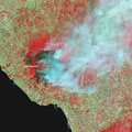
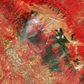
Mount Vesuvius fire21 July 2017 - A series of wildfires began on the slopes of Mount Vesuvius in Italy recently. The fires consumed 9 square kilometres of forest, and Sentinel-2 was used to monitor the wide extent of the affected area on 12 July. 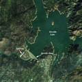
Oroville Dam crisis23 February 2017 - These image comparisons from the Landsat 7 and Sentinel-2 satellites show the state of Oroville Dam in California, USA, which was recently at risk of flooding the nearby town of Oroville. 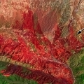
California fires26 August 2016 - This Landsat 8 image comparison shows a wildfire raging through drought-parched canyons near Cajon Pass in Southern California, which has forced the mandatory evacuation of thousands of people. 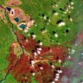
Fires at Fort McMurray, Canada31 May 2016 - The massive fire in Alberta, Canada, continues to burn, affecting the 90,000 residents of the city of Fort McMurray. This Landsat 5 and 8 image comparison shows the situation at Fort McMurray two weeks after the fires began. 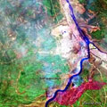
Fire at Fort McMurray, Canada10 May 2016 - A large wildfire has been raging in the city of Fort McMurray in Canada since the start of May. The city, home to over 90,000 people, was evacuated on 3 May and this Landsat 8 comparison examines the city before and after the fires began. |
||