- All Categories (13636)
- Data (3)
- News (54)
- Missions (31)
- Events (18)
- Tools (3)
- Activities (9)
- Campaigns (2)
- Documents (13516)
News - Success Stories

Publication of Coastal Current Intrusions from Satellite Altimetry
A new study entitled “Coastal current intrusions from satellite altimetry” has just been published in the journal Remote
News - Success Stories
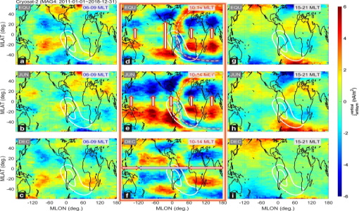
CryoSat-2 Data Used to Measure Ionospheric Currents
Recovery and Climate Experiment Follow-On (GRACE-FO) satellites can be used to diagnose weak low-/mid-latitude ionospheric currents
Document - Conference Presentation - Poster

Global-Surface-Geostrophic-Currents-From-Satellite-Altimetry-and-GOCE
Global Surface Geostrophic Currents from Satellite Altimetry and GOCE J.M. Sánchez-Reales, I. Vigo, S.G. Sin & B.F. Chao
Mission - Earth Explorers

GOCE
Explorer (GOCE) mission mapped Earth's geoid very accurately, opening a window into Earth's interior structure as well as the currents
Document - General Reference

Earth-Explorers-Satellites-to-understand-our-changing-Earth.pdf
This eight-page brochure provides an overview of the Earth Explorers currently in orbit and those under development.
Event - Workshop

2nd Space for Hydrology Workshop
The workshop aimed to assess the current stage of knowledge and activities in space-based hydrological observations and to
Document - General Reference
SCI-PUB-14-0002-v01-WMO-report-1.0.pdf
The ERS Scatterometers in the Global Climate Observing System report describes the current and anticipated relationship and
Document - Proceedings

First-International-GOCE-Workshop-GOCE-Germany-Oceanography.pdf
describes using data from the GOCE satellite mission in order to determine structure and transport of the Antarctic Circumpolar Current
News - Success Stories
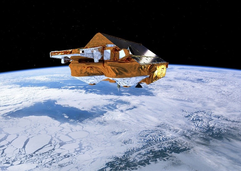
CRYO2ICE over Antarctica: revealing further insight on changing ice
The CryoSat-2 satellite is currently being aligned with ICESat-2 over Antarctica, unlocking fresh possibilities in the wealth
Document - Software Verification Plan/Report

GUT2-WP6000-Final-Report.pdf
combined to models of the marine geoid to estimate the ocean Mean Dynamic Topography, and, by geostrophy, the ocean mean currents
News - Success Stories
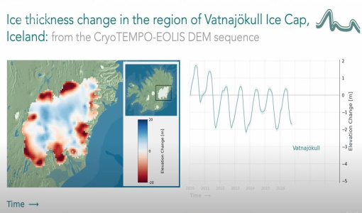
CryoTEMPO-EOLIS Products Now Available for Iceland, Svalbard, and the Canadian Arctic
Land-ice monitoring via Earth Observation methods in general, and altimetry in particular, are essential for tracking the current
Data - Fast Registration with approval (Restrained)
ERS-1/2 ATSR Averaged Surface Temperature [AT1/AT2_AR__2P]
sets provide, for sea cells, nadir and dual view sea surface temperatures, and for land cells, land surface temperature (currently
Data - Fast Registration with immediate access (Open)

ERS PRARE Precise Orbit Product (ERS.ORB.POD/ERS.ORB/PRC)
Several orbit solutions are currently distributed: A new set of ORB POD (Precise Orbit Determination - REAPER v2) computed
Tools - Analysis

GOCE User Toolbox
Data output formats The current data formats that GUT can provide in output are: netCDF (Climate and Forecast Metadata Convention
News - Events and Proceedings
GLOC 2023: Democratising data access key to climate action
Currently, more than a trillion tonnes of ice is lost each year.
Event - Workshop
GOCE - 4th International User Workshop 2011 sessions
On the Current Status of the Cooperative Research Project Real Data Analysis GOCE (REAL GOCE) W.-D. Schuh & B.
Activity - Quality
SCIRoCCo
Author: The SCIRoCCo Team Abstract: The ERS Scatterometers in the Global Climate Observing System report describes the current
Event - Workshop

SEASAR 2012
Aouf 14:00 - 14:20 Towards consistent inversion of wind, waves and surface current from SAR Bertrand Chapron (IFREMER, France
Activity - Instrument characterisation and algorithm studies

ESA satellites and instruments calibration landing page
Data Outages: Information currently not available online.
News - Thematic area articles

How satellite data help to shape society
Title: Current drought situation in Ebro basin Description: The SMOS soil-moisture-based drought monitor is updated monthly