- All Categories (17024)
- Data (2)
- News (55)
- Missions (41)
- Events (22)
- Activities (2)
- Campaigns (2)
- Documents (16900)
Mission - Earth Explorers

GOCE
Explorer (GOCE) mission mapped Earth's geoid very accurately, opening a window into Earth's interior structure as well as the currents
Mission - Heritage Missions
MOS-1/1B
MOS-1 and 1B, Japan’s first marine observation satellites, were designed to monitor ocean currents, sea surface temperature
Document - Proceedings

Emerging-Scatterometer-Applications-from-Research-to-Operations.pdf
The objective of the Workshop, held on 5-7 October 1998 at ESA-ESTEC (Noordwijk, The Netherlands), was to review the current
Mission - Earth Explorers

Aeolus
This is currently the only technology that can provide direct wind profile observations in clear air, inside thin clouds
News - General News
Go-to guide to Third Party Mission data offering
Data Access Guide has been published, providing technical details and information on available data collections for all current
Event - Meeting

VH-RODA and CEOS SAR workshop
The workshop provided an open forum for the presentation and discussion of current status and future developments related
News - Success Stories
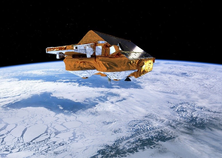
CRYO2ICE over Antarctica: revealing further insight on changing ice
The CryoSat-2 satellite is currently being aligned with ICESat-2 over Antarctica, unlocking fresh possibilities in the wealth
News - Success Stories
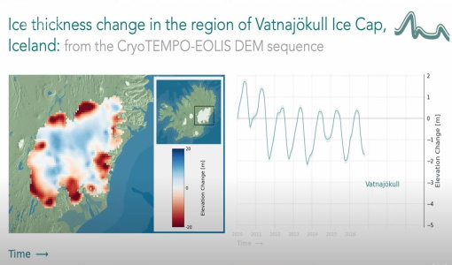
CryoTEMPO-EOLIS Products Now Available for Iceland, Svalbard, and the Canadian Arctic
Land-ice monitoring via Earth Observation methods in general, and altimetry in particular, are essential for tracking the current
Document - Proceedings
3rd International Symposium on Retrieval of Bio and Geophysical Parameters from SAR Data for Land Applications
This Symposium provided a snapshot of where we currently stand in exploiting SAR data to understand geophysical and biophysical
Mission - Third Party Missions

ICEYE
Currently, the satellites operate in five modes called 'Strip Mode', 'Spot Mode', 'Scan Mode', 'Spot Extended Area (SLEA)
Event - Workshop

ISSPI: 1st International Satellite Snow Product Intercomparison Workshop
to bring together scientists and institutions working in seasonal snow pack monitoring in order to assess the quality of current
Mission - Heritage Missions

Seasat
The instrument had the objectives of the determination of sea surface profiles, currents, wind speeds and wave heights.
Data - Project Proposal (Restrained)

Spire live and historical data
The data also provides interesting research opportunities on topics as varied as ocean currents and GNSS-based planetary
News - Events and Proceedings
GLOC 2023: Democratising data access key to climate action
Currently, more than a trillion tonnes of ice is lost each year.
Event - Workshop
IDEAS+ Cal/Val Workshop 7
Regular workshops are held every nine months with the whole IDEAS+ Task 3-Cal/Val team in order to review the status of current
Mission - Earth Explorers
Aeolus Data
Aeolus Quality Control Reports on L1B/Instrument, L2A and L2B products are currently available to Aeolus Cal/Val teams and
Mission - Earth Explorers
ALADIN
Aeolus Quality Control Reports on L1B/Instrument, L2A and L2B products are currently available to Aeolus Cal/Val teams and
Activity - Quality
SCIRoCCo
Author: The SCIRoCCo Team Abstract: The ERS Scatterometers in the Global Climate Observing System report describes the current
Event - Workshop

SEASAR 2012
Aouf 14:00 - 14:20 Towards consistent inversion of wind, waves and surface current from SAR Bertrand Chapron (IFREMER, France
Mission - Earth Explorers
SMOS product availability
+ NIR + Long LO + FTT LO + Electrical Stability LO + NIR + Long + FTT LO + Short LO + Long + Short Current