- All Categories (42)
- News (7)
- Missions (13)
- Events (10)
- Activities (1)
- Documents (11)
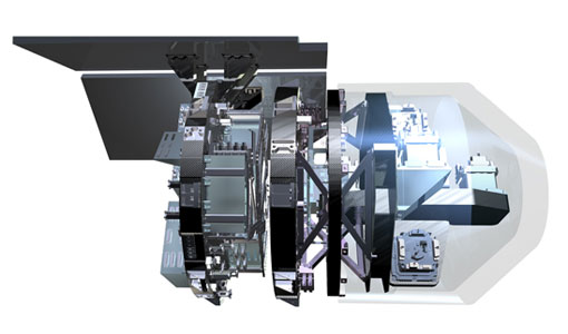
Mission - Earth Explorers

GOCE
Explorer (GOCE) mission mapped Earth's geoid very accurately, opening a window into Earth's interior structure as well as the currents
Activity - Quality
SCIRoCCo
Author: The SCIRoCCo Team Abstract: The ERS Scatterometers in the Global Climate Observing System report describes the current
Event - Workshop

SEASAR 2012
Aouf 14:00 - 14:20 Towards consistent inversion of wind, waves and surface current from SAR Bertrand Chapron (IFREMER, France
Event - Training

EO Summer School 4
Keynote lectures on global change issues are also given to discuss the current state of the science of global change and
Mission - Earth Explorers
GOCE Objectives
Thanks to this current, the coastal waters of Europe are 4°C warmer than waters at equivalent latitudes in the north Pacific
Event - Workshop

SEASAR 2006
requirements Formulate recommendations for algorithm and new products development To present ESA studies results on wind, wave and currents
Event - Training
EO Summer School 3
In line with observations it shows anti-cyclonically rotating surface currents and cyclonically rotating bottom currents.
Event - Training
EO Summer School 5
Keynote lectures on global change issues are also given to discuss the current state of the science of global change and
Mission - Heritage Missions

RA (ERS)
the RA provided information on significant wave height; surface wind speed; sea surface elevation, which relates to ocean currents
News - Data Release news

New reprocessing of datasets celebrates 30 years of ERS
For each surface, the experts will use our current knowledge acquired over 30 years of experience, to improve the ERS altimetric
News - Thematic area articles

Satellite data central to ocean monitoring
microwave monitoring instruments, optical imagers, and infrared radiometers, which can map ocean variables related to ocean currents
Event - Workshop

Fringe 2011 Workshop
The Fringe series of workshops started in 1992 and they are currently organised by ESA every two years.
Mission - Earth Explorers
EGG
This opened a window into Earth's interior structure, as well as the currents circulating within the depths of its oceans
Mission - Heritage Missions

ERS Radar Course 1
Therefore, microwaves easily penetrate clouds, and images can be acquired independently of the current weather conditions
Mission - Earth Explorers
SSTI ANTEX Data
data were generated from 154 days in 2009 GOCE SSTI-B PCVs data were generated from the available data in 2010-2012 The current
News - Infographics
Showcasing success stories from ESA's Heritage Missions
success stories showcased used data from ESA's ERS (European Remote Sensing) and Envisat satellites in combination with current
Document - General Reference

The Nine Candidate Earth Explorer Missions - Topography Mission
This report for assessment addresses the Topography mission when it was selected with other nine Earth Explorer missions as a potential candidate for Phase A study.
Document - Proceedings

EO-Summer-School-6-ESA-explorer-mission-GOCE-earth-gravity-from-space.pdf
This presentation from ESA's EO Summer School 6 presents the ESA explorer mission GOCE earth gravity from space
Mission - Heritage Missions
GOCE re-entry dataset
with further dynamical and environmental information such as on-board magnetometer measurements of Earth's magnetic field, currents
Mission - Earth Explorers
GOCE Overview
height mapped by altimeters and the knowledge of the precise ocean geoid that has improved our understanding of surface currents