- All Categories (18)
- News (1)
- Missions (3)
- Events (1)
- Activities (2)
- Documents (11)
News - Success Stories
A stroll through Heritage Missions
In the current digital era, this confirms ESA’s commitment to maintain heritage data and keep information available, in support
Event - Workshop
Coastal and Marine Applications of SAR Workshop 2003
Applications were specifically focussed on wind, waves, sea ice, and currents.
Activity - Quality
EDAP
The following missions are currently being considered as part of the Automatic Identification System (AIS) and Radio Frequency
Document - General Reference
Heritage Missions brochure
This brochure describes ESA's Heritage Space Programme and includes infographics describing some of the missions in the programme.
Document - Product Specifications
JERS-SeaSat-SAR-Level-1-products-format-specifications.pdf
This document defines the Envisat and GEOTIFF/TIFF format of the L1 products generated from JERS/SeaSat SAR sensor data by the ESA JERS SAR Instrument Processing Facility.
Document - Product Specifications
JERS-SeaSat-SAR-Products-CEOS-Format-Specifications.pdf
This document defines the format of the SAR RAW, PRI, IMM and SLC products generated from JERS-1 and SeaSat SAR data by the ESA JERS and SeaSat SAR Instrument Processing Facilities.
Document - Product Document
LANDSAT_Products_Description_Document.pdf
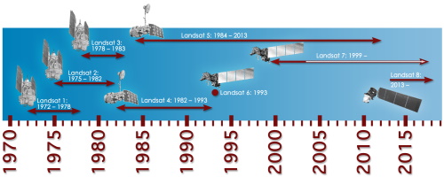
This document acts as a User Guide to the Landsat MSS, TM and ETM+ archives, focussing more specifically on the Landsat TM and ETM+ products from the Kiruna, Maspalomas and Matera archives (including from the Matera, Fucino, Neustralitz, O’Higgins, Malindi, Libreville and Bishkek ground stations) that have been generated as part of the ESA archive bulk-reprocessing project.
Mission - Third Party Missions
Multi Spectral Scanner (MSS) Processor Releases
GCP displacement B TM radiometric calibration Update to radiometric calibration strategy for TM reflective bands (Dark Current
Mission - Heritage Missions
Seasat
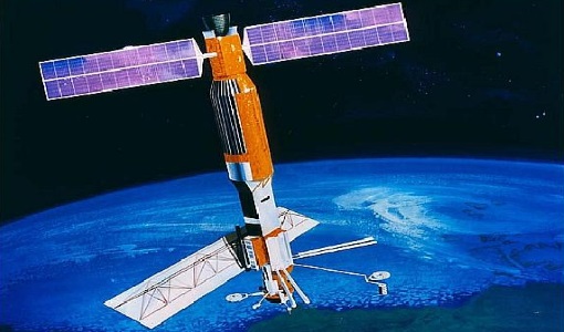
The instrument had the objectives of the determination of sea surface profiles, currents, wind speeds and wave heights.
Mission - Heritage Missions
Seasat Objectives
wealth of information on diverse ocean phenomena such as sea-surface winds and temperatures, surface and internal waves, currents
Document - Technical Note
SeaSat-SAR-IPF-Data-and-Processing-Issues.pdf
This document describes the rehabilitation and reprocessing of ESA’s historic SeaSat raw data archive.
Activity - Quality
SLAP
Currently, in excess of 701,000 Level 1 TM and 84,000 Level 1 ETM+ products have been reprocessed and released under the
Document - Technical Note
Technical Note on Quality Assessment for Landsat 1-7
Technical Note on Quality Assessment for Landsat 1-7
Document - General Reference
The Earth Observation Handbook, 2010 Update - Key Tables
This is the 2010 update of the CEOS Earth Observation Handbook. You can browse the live database at http://database.eohandbook.com/ or download the printable PDF of key tables based on the 2010 database contents for a handy reference.
Document - Technical Note
The SeaSat-A Synthetic Aperture Radar System
The SeaSat-A synthetic aperture radar imaging radar system (SAR) was the first imaging radar system used as a scientific instrument from Earth orbit. The system generated continuous radar imagery with a 100 km swath at a resolution of 25 m from an 800 km altitude orbit. The imagery is a pictorial representation of the radar backscatter of the Earth's surface in a map-like representation.


