- All Categories (236)
- Data (2)
- News (21)
- Missions (3)
- Events (10)
- Tools (2)
- Activities (6)
- Documents (192)
News - Success Stories

1 km resolution aerosol optical thickness retrieved from PROBA-V
The ESA SPAR@MEP project aims to deliver a long-term data record (LTDR) of aerosol optical properties and surface reflectance from SPOT-VGT and PROBA-V observations.
News - Infographics

A summary of ESA Third Party Mission collections
A new summary is available, showcasing the ESA archives for Third Party Mission collections.
Document - Technical Note

Algorithm Theoretical Baseline Document for the Geometric Calibration
Proba-V IQC-GC ATBD - Algorithm Theoretical Baseline Document for the Geometric Calibration
News - General News
Campaign using surface reflectance data to support validation of Earth observation products
Scientists from around the world are set to take part in a drone monitoring campaign and inter-comparison exercise that will deliver surface reflectance data to support the validation of Earth observation products.
Document - General Reference

CD17-NO19-Knaeps-FINAL.pdf
COASTAL TURBIDITY MONITORING USING THE PROBA-V SATELLITE PAPER
Activity - Instrument characterisation and algorithm studies

ESA satellites and instruments calibration landing page
ESA satellites and instruments calibration landing page.
Document - Data Access Information

ESA-archive-third-party-mission-collections.pdf
Discover the ESA archive data collections offered for the Third Party Missions programme.
Tools - Visualisation
EVDC Orbit Prediction Tool
The EVDC Orbit Prediction and Overpass Tool generates and visualises satellite's overpasses.
Document - Technical Note
Feedbacks-on-PROBA-V-Collection-1.pdf
Proba-V heritage mission: SPOT-VGT data processing and dissemination - Scientific paper providing overview of SPOT-VGT 15-years of data processing and dissemination.
Activity - Fiducial Reference Measurements
FRM4GHG: Reference Measurements for Ground-Based FTIR Greenhouse Gas Observation
Fiducial Reference Measurements for Ground-Based Infrared Greenhouse Gas Observations (FRM4GHG) is a European Space Agency (ESA) funded project.
Activity - Fiducial Reference Measurements
FRM4VEG: Fiducial Reference Measurements for Vegetation
Fiducial Reference Measurements for Vegetation (FRM4VEG) is an ESA managed project focused on establishing the protocols required for traceable in-situ measurements of vegetation
News - Thematic area articles
Global understanding of Earth's land surfaces greatly boosted by satellite data
ESA perform land surface monitoring with a range of instruments onboard satellites acquiring optical and radar data. Collections of data from these missions are freely available for research purposes.
News - Operational News

GOSAT data dissemination schedule until 6 May 2020
The GOSAT product generation and distribution is currently impacted by changes at the JAXA Tsukuba Space Center.
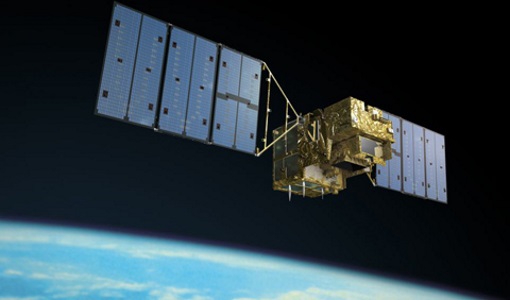
Mission - Third Party Missions

GOSAT Series
The GOSAT series is composed of two environment-monitoring satellites developed by JAXA dedicated to the observation of greenhouse gases.
Data - Fast Registration with immediate access (Open)
GOSAT TANSO FTS and CAI full archive and new products
The TANSO-FTS instrument on-board GOSAT satellite features high optical throughput, fine spectral resolution, and a wide spectral coverage (from VIS to TIR in four bands). The reflective radiative energy is covered by the VIS and SWIR (Shortwave Infrared) ranges, while the emissive portion of radiation from Earth's surface and the atmosphere is covered by the MWIR (Midwave Infrared) and TIR (Thermal Infrared) ranges. These spectra include the absorption lines of greenhouse gases such as carbon dioxide (CO2) and methane (CH4). The TANSO-CAI instrument on-board GOSAT satellite is a radiometer in the spectral ranges of ultraviolet (UV), visible, and SWIR to correct cloud and aerosol interference. The imager has continuous spatial coverage, a wider field of view, and higher spatial resolution than the FTS in order to detect the aerosol spatial distribution and cloud coverage. Using the multispectral bands, the spectral characteristics of the aerosol scattering can be retrieved together with optical thickness. In addition, the UV-band range observations provide the aerosol data over land. With the FTS spectra, imager data, and the retrieval algorithm to remove cloud and aerosol contamination, the column density of the gases can be the column density of the gases can be retrieved with an accuracy of 1%. The full ESA archive and newly acquired/systematically processed GOSAT FTS and CAI products are available in the following processing levels: FTS Observation mode 1 L1B, day (FTS_OB1D_1) FTS Observation mode 1 L1B, night (FTS_OB1N_1) FTS Special Observation L1B, day (FTS_SPOD_1) FTS Special Observation L1B, night (FTS_SPON_1) FTS L2 CO2 profile, TIR (FTS_P01T_2) FTS L2 CH4 profile, TIR (FTS_P02T_2) FTS L2 CH4 column amount, SWIR (FTS_C02S_2) FTS L2 CO2 column amount, SWIR (FTS_C01S_2) FTS L2 H2O column amount, SWIR (FTS_C03S_2) FTS L3 global CO2 distribution, SWIR (FTS_C01S_3) FTS L3 global CH4 distribution, SWIR (FTS_C02S_3) FTS L4A global CO2 flux, annual in text format (FTS_F01M4A) FTS L4A global CO2 flux, annual in netCDF format (FTS_F03M4A) FTS L4A global CO2 distribution (FTS_P01M4B) FTS L4A global CH4 flux, annual in text format (FTS_F02M4A) FTS L4A global CH4 flux, annual in netCDF format (FTS_F04M4A) FTS L4A global CH4 distribution (FTS_P02M4B) CAI L1B data (CAI_TRB0_1) CAI L1B+ (CAI_TRBP_1) CAI L2 cloud flag (CAI_CLDM_2) CAI L3 global reflect. distrib. clear sky (CAI_TRCF_3) CAI L3 global radiance distrib. all pixels (CAI_TRCL_3) CAI L3 global NDVI (CAI_NDVI_3). All products are made available as soon as processed and received from JAXA. To satisfy NearRealTime requirements, ESA also provides access to the FTS L1X products, which are the NRT version of FTS L1B products. The main difference between L1X and L1B is that L1X does not include CAM data, best-estimate pointing-location, and target point classification, but most of all the L1X products are available on the ESA server between 2 and 5 hours after acquisition. The L1X products remains on the FTP server for 5 days, the time for the corresponding L1B to be available. A document describing the differences between L1X and L1B products is listed in the available resources. For more details on products, please refer to below product specifications.
News - Operational News
GOSAT – TANSO-FTS observations unavailability
Due to an inclination control manoeuvre of the JAXA GOSAT-1 satellite, the TANSO-FTS sensor observations have been suspended.
Document - Product Document

GOSAT-Level-1-Product-Format-Description-Document.pdf
This document describes TANSO-FTS Level 1 products produced with GOSAT data processing system.
Document - Publication - Paper

IGARSS-2017-cloud-detection-machine-learning-algorithms-proba-v.pdf
Cloud detection machine learning algorithms for Proba-V, IGARSS 2017
Event - Conference

Living Planet Symposium 2022
Learn about the 2022 edition of ESA's Living Planet Symposium.