- All Categories (35)
- Data (6)
- News (13)
- Missions (4)
- Events (7)
- Tools (2)
- Campaigns (3)
News - Events and Proceedings

Φ-Week Triumphs
In its fourth edition, Φ-Week presented the scientific community with amazing opportunities and projects—thus running alongside innovation at 360 degrees.
News - Thematic area articles
Tracking the world’s forests from space
As human activities continue to threaten the planet’s forests, data delivered by satellites are boosting global efforts to conserve these crucial natural resources.
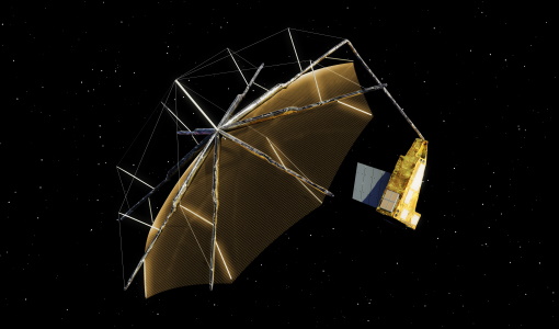
News - Infographics
Showcasing the NovaSAR-1 radar satellite
Learn about the NovaSAR-1 mission in our new infographic.
News - Data Release news
PROBA-V ‘Collection 2’ - Reprocessed Dataset available
The improved PROBA-V data (Collection 2) has been released. Data is available via the PROBA-V MEP and Terrascope platforms so users can freely exploit the data using Virtual machines, Jupyter Notebooks, and the new viewing application.
News - Success Stories
PROBA-V data improve surface albedo products in Africa
As ESA’s PROBA-V satellite marks its 10-year launch milestone, data tasked during the mission’s lifetime are still being used to assess changes in land cover.
Event - Meeting

Proba-V Cloud Detection Round Robin Meeting
A Round Robin exercise aimed at the inter-comparison of different cloud detection algorithms for Proba-V has been organised by the European Space Agency (ESA) and the Belgian Science Policy Office (BELSPO).
Data - External Data (Restrained)
PROBA-V 1 km, 333 m, and 100 m products
The PROBA-V VEGETATION Raw products and Synthesis products provided coverage of all significant landmasses worldwide with, in the case of a 10-day synthesis product, a minimum effect of cloud cover, resulting from selection of cloud-free acquisitions during the 10-day period. It provided a daily coverage between Latitudes 35°N and 75°N, and between 35°S and 56°S, and a full coverage every two days at the equator. The VEGETATION instrument was pre-programmed with an indefinite repeated sequence of acquisitions. This nominal acquisition scenario allowed a continuous series of identical products to be generated, with the goal to map land cover and vegetation growth across the entire planet every two days. Level Synthesis Resolution resolution (m) Reflectance Level-1C n/a TOA Level-2A n/a 100 m TOA 333 m TOA 1 km TOA Level-3 S1 100 m TOA TOC TOC NDVI 333 m TOA TOC 1 km TOA TOC S5 100 m TOA TOC TOC NDVI S10 333 m TOC TOC NDVI 1 km TOC TOC NDVI Raw Products Overview Product Description Level-1C Level-1C segments (P – product): Radiometrically corrected Level-1B data, in raw sensor geometry (unprojected) Contains: - Top Of Atmosphere reflectance in the four spectral bands - Longitude/latitude information for every pixel - Geometric viewing conditions - Information on the status map (indicating missing and interpolated measurements). Format: HDF5 & GeoTiFF Level-2A Level-2A segment: projected Level-1C (P–product) data, radiometrically and geometrically corrected. Contains: - TOA reflectance values in the four spectral bands without atmospheric correction being performed - Information on the status map (containing identification of radiometric quality, snow, ice, shadow, clouds, land/sea for every pixel) - Geometric viewing conditions Plate carrée projection (EPSG:4326) with spatial resolution of 100 m, 333 m and 1 km Format: HDF5 & GeoTiFF Synthesis Products Overview Level-3 S1 = daily, S5 = 5 days, S10 = decade Different spatial resolution: 100 m, 333 m and 1 km Divided into so called granules, each measuring 10 degrees x 10 degrees, each granule being delivered as a single file Plate carrée projection (EPSG:4326) Format: HDF5 & GeoTiFF Products Content TOA - Top Of Atmosphere reflectance in the four spectral bands (no atmospheric correction applied) - Normalized Difference Vegetation Index (NDVI) -Information on the composite status map (containing identification of snow, ice, shadow, clouds, land/sea for every pixel) - Geometric viewing conditions & date and time of selected measurement TOC Level-2A segment: projected Level-1C (P–product) data, radiometrically and geometrically corrected. Contains: - Top Of Canopy (ground surface) reflectance in the four spectral bands, the atmospheric correction being performed using the SMAC (Simplified Method for Atmospheric Corrections) algorithm - Normalized Difference Vegetation Index (NDVI) - Information on the composite status map (containing identification of snow, ice, shadow, clouds, land/sea for every pixel) Normalized Difference Vegetation Index (NDVI) from Top Of Canopy product (SMAC algorithm for atmospheric corrections applied) - Geometric viewing conditions & date and time of selected measurement TOC NDVI Normalized Difference Vegetation Index (NDVI) from Top Of Canopy product (SMAC algorithm for atmospheric corrections applied)
Mission - Earth Watch

PROBA-V
The PROBA-V mission provides multispectral images to study the evolution of the vegetation cover on a daily and global basis.
Event - Workshop

POLinSAR 2007
The POLinSAR 2007 workshop was open to ESA Principal Investigators and co-investigators, scientists and students working in the field of SAR Polarimetry and Polarimetric Interferometry, and to representatives from national, European and international space agencies and value adding industry.
Mission - Third Party Missions
NovaSAR-1
Launched on 16 September 2018, NovaSAR-1 features an S-band synthetic aperture radar (SAR) instrument offering a variety of modes with different resolutions and swath widths.
News - Data Release news
New FLEX-related campaign datasets released
New datasets have been released for three campaigns, covering activities supporting the upcoming FLEX mission.
News - Data Release news
New BorealScat campaign dataset released
A new dataset has been released for the BorealScat campaign, which took place between 2017 and 2021 in Sweden.
News - General News

ICEYE data available for assessment
The SAR user community is invited to participate to the call to assess the suitability of the ICEYE constellation, for science and EO-based applications.
News - Success Stories

How scientists are unlocking the potential of SAOCOM
A team of scientists has drawn on SAOCOM data to measure the heights of forests in Argentina, marking the first time that tree canopies have been mapped using the two-satellite constellation.
Tools - Other

Forestry TEP
The Forestry Thematic Exploitation Platform (TEP) enables users in the forestry sector to access satellite data based processing services and tools for generating value-added forest information products.
Tools - Other

Food Security TEP
The Food Security Thematic Exploitation Platform (TEP) enables access, processing, uploading, visualisation, manipulation and comparison of data related to food security.
Event - Meeting
Fluorescence (FLEX) 2019
The FLEX 2019 meeting consisted of a series of events addressing remote sensing of vegetation fluorescence.
News - Success Stories
ESA's open source computing project for the Biomass mission goes live
The Biomass Product Algorithm Laboratory (BioPAL) is an open-source scientific computing project, which supports the development of ESA’s Biomass mission algorithms coded in Python.
News - Announcement of Opportunity updates
ESA encourages S-band applications with NovaSAR-1 Announcement of Opportunity
ESA is offering possibilities to develop new applications in the S-band microwave frequency range, with a new Announcement of Opportunity for NovaSAR-1 data, via ESA’s Third Party Mission programme.
News - Success Stories

Drone-based Laser Scanning of Tropical Forests for Biomass Cal/Val
ESA’s upcoming mission Biomass will deliver valuable P-band SAR data aimed at forest aboveground biomass (AGB) estimation across the humid tropics.