- All Categories (94)
- Data (10)
- News (29)
- Missions (9)
- Events (3)
- Tools (8)
- Campaigns (2)
- Documents (33)
News - Success Stories
A stroll through Heritage Missions
At ESA's Earth Observation centre—ESRIN—in Frascati, Italy, there is a place where one can walk back in time, to better understand the history and importance of Heritage Missions and their data.
News - Infographics
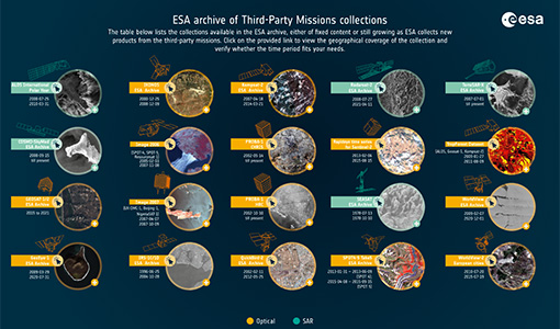
A summary of ESA Third Party Mission collections
A new summary is available, showcasing the ESA archives for Third Party Mission collections.
Document - Proceedings
Advances-in-Atmospheric-Science-and-Applications.pdf
Proceedings in Advances in Atmospheric Science and Applications held in 18-22 June 2012 in Bruges, Belgium.
News - Infographics
An overview of ESA's Third Party Missions programme
ESA’s Third Party Missions programme consists of almost 50 satellite missions, which are owned by organisations around the world. ESA has agreements with these organisations to acquire, process, and distribute data from their missions
Campaign
BACCHUS-DOC
The BACCHUS-DOC Radar and Optical Campaign was an area mapping project of vineyards near Frascati (Italy). ESA required high resolution geo-referenced airborne SAR data of different wavelength and polarisation (preferably polarimetric).
Data - Campaigns (Open)
BACCHUS-DOC
The BACCHUS-DOC Radar and Optical Campaign was an area mapping project of vineyards near Frascati (Italy). ESA required high resolution geo-referenced airborne SAR data of different wavelength and polarisation (preferably polarimetric).
Document - General Reference
BIOMASS-Report-for-Mission-Selection-An-Earth-Explorer-to-observe-forest-biomass.pdf
The objective of the BIOMASS Mission is to determine the global distribution of forest biomass by reducing the uncertainty in the calculation of carbon stock and fluxes associated with the terrestrial biosphere.
Data - Announcement of Opportunity (Restrained)
Closed ESA announcement of opportunities
Find out about closed ESA announcement of opportunities and what these opportunities involved, for historical reference.
News - Thematic area articles
Cloud-free collections key for land monitoring
Satellite imagery is a crucially important tool for monitoring the land, but cloud cover can often block parts of Earth’s surface from view, limiting subsequent analyses.
News - Success Stories
Commercial and international data for fire monitoring
As climate change sparks a surge in the frequency and intensity of wildfires, satellite data disseminated through ESA’s Third Party Missions (TPM) programme are helping scientists to track and investigate these potentially damaging natural events.
Document - General Reference
CoReH2O-Report-for-Mission-Selection-An-Earth-Explorer-to-observe-snow-and-ice.pdf
This report describes the CoReH2O (Cold Regions Hydrology high-resolution Observatory) mission, which was selected for feasibility study in the third cycle of Earth Explorers.
Document - Conference Presentation - Poster
D3P1b_msavinaud_LTC2013.pdf
D3P1b ORFEO Toolbox M. Sauvinaud
Document - Conference Presentation - Poster
D4P1a_Yesou_LTC2013 (1).pdf
D4P1a (cont.) Floods & Lakes Monitoring H. Yesou
Document - Conference Presentation - Poster
D4P1a_Yesou_LTC2013.pdf
D4P1a Floods & Lakes Monitoring H. Yesou
Document - General Reference
Earth-from-Space-North-America.pdf
This brochure is a collection of Envisat MERIS, Envisat ASAR, Envisat AATSR, ERS, Proba and SPOT mosaics of North America.
Tools - Catalogues
EO CAT
EO CAT is a data catalogue, offering a Next Generation Earth Observation system designed to manage end-user Earth Observation services.
Event - Training
EO Summer School 4
ESA's series of summer schools, on Monitoring of the Earth System, aims to promote the exploitation of Earth observation data.
Event - Training
EO Summer School 5
ESA's series of summer schools, on Monitoring of the Earth System, aims to promote the exploitation of Earth observation data.
Document - Proceedings
EO-Summer-School-2-Overview-of-land-surface-parameters-from-EO.pdf
Overview of land surface parameters from Earth Observation


