- All Categories (46)
- Data (4)
- News (25)
- Missions (4)
- Events (11)
- Documents (2)
Event - Meeting

World Ocean Circulation User Consultation Meeting 2019
The World Ocean Circulation User Consultation Meeting took place in 2019 with the aim to prepare a roadmap for new initiatives on ocean circulation research and applications.
Event - Workshop

Understanding the Carbon and Water Cycles using SMOS Data and Models
The workshop aimed to bring together the EO, SMOS, Earth system science and modelling communities involved in the observation, characterisation and forecasting of land surface processes and their impacts.
News - Success Stories

Swarm unveils magnetic waves deep down
Using information from ESA’s Swarm satellite mission, scientists have discovered a completely new type of magnetic wave that sweeps across the outermost part of Earth’s outer core every seven years.
Mission - Earth Explorers

Swarm Product Data Handbook
The Swarm Product Data Handbook provides a detailed description of Level 1b and Level 2 products derived from Swarm data.
News - General News
Swarm is turning 10 - Bake a cake and celebrate with us!
Bake a cake to celebrate the 10th anniversary of Swarm!
News - Data Release news

Swarm FAST data ready to be released
Swarm FAST data will be available on the ESA Swarm dissemination server from 2 November onwards.
News - Operational News
Swarm Bravo GPS anomaly on 16 June 2023
A loss of GPS Time Synchronisation registered on Swarm Bravo on 13 June 2023 has affected all of the Swarm Bravo instruments.
News - Operational News
Swarm Bravo Data Gap on 4 June 2023
All of the L1A and L1B data production for 4 June 2023 has been processed and disseminated in two parts.
News - Operational News
Swarm Alpha VFM anomaly from 16 to 20 June 2023
Due to an issue registered on the VFM on board Swarm Alpha, several gaps have been identified in the VFM science data from 16 June to 20 June.
News - Infographics
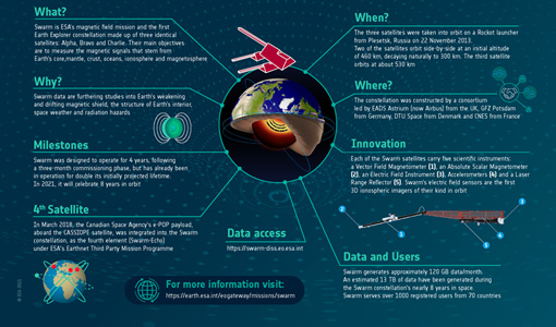
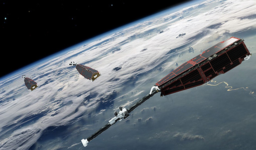
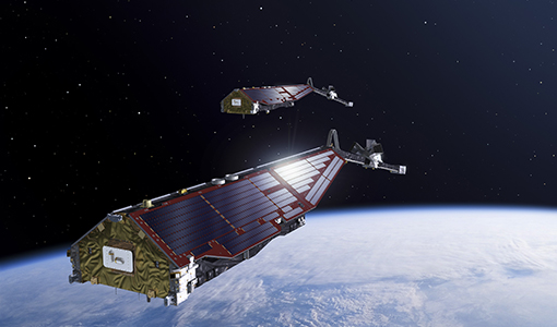
Swarm - ESA's magnetic field satellite mission
Learn more about ESA's Swarm mission, an Earth Explorer dedicated to studying Earth's magnetic field, in our latest infographic.
Event - Workshop
Space and the Arctic 2009 Workshop
Temperatures in the Arctic are rising at an unprecedented rate. This workshop looked at the needs and challenges of working and living in the rapidly changing Arctic and explore how space-based services might help to meet those needs.
Data - EO Sign In Authentication (Open)
SMOS Tropical Cyclone Wind Radii Fixes
The SMOS WRF product is available in Near Real Time to support tropical cyclones (TC) forecasts. It is generated within 4 to 6 hours from sensing from the SMOS L2 swath wind speed products, in the so-called "Fix (F-deck)" format compatible with the US Navy's ATCF (Automated Tropical Cyclone Forecasting) System. The SMOS WRF "fixes" to the best-track forecasts contain: the SMOS 10-min maximum-sustained winds (in knots) and wind radii (in nautical miles) for the 34 kt (17 m/s), 50 kt (25 m/s) and 64 kt (33 m/s) winds per geographical storm quadrants, and for each SMOS pass intercepting a TC in all the active ocean basins.
Data - EO Sign In Authentication (Open)
SMOS NRT L2 Swath Wind Speed
SMOS retrieved surface wind speed gridded maps (with a spatial sampling of 1/4 x 1/4 degrees) are available in NetCDF format. Each product contains parts of ascending and descending orbits and it is generated by Ifremer, starting from the SMOS L1B data products, in Near Real Time i.e. within 4 to 6 hours from sensing time. Before using this dataset, please check the read-me-first note available in the Resources section below.
Data - EO Sign In Authentication (Open)
SMOS L3 Daily Wind Speed
SMOS L3WS products are daily composite maps of the collected SMOS L2 swath wind products for a specific day, provided with the same grid than the Level 2 wind data (SMOS L2WS NRT) but separated into ascending and descending passes. This product is available the day after sensing from Ifremer, in NetCDF format. Before using this dataset, please check the read-me-first note available in the Resources section below.
News - Operational News

SMOS data outage since 22 February 2024
SMOS went into safe mode on 22 February 2024 at 05:10 UTC for reasons that are still under investigation.
News - Operational News

SMOS data distribution resumed
SMOS data distribution to end users was resumed on 12 March 2024 after confirmation of the adequate quality of the current data.
Mission - Earth Explorers

SMOS
The Soil Moisture and Ocean Salinity (SMOS) mission is dedicated to making global observations of soil moisture over land and salinity over oceans.
Data - EO Sign In Authentication (Open)
SeaSat ESA archive
This collection gives access to the complete SEASAT dataset acquired by ESA and mainly covers Europe. The dataset comprises some of the first ever SAR data recorded for scientific purposes, reprocessed with the most recent processor. The Level-1 products are available as: SAR Precision Image [SEA_PRI_1P] SAR Single Look Complex Image [SEA_SLC_1P] SAR Ellipsoid Geocoded Precision Image [SEA_GEC_1P] Spatial coverage: Check the spatial coverage of the collection on a map available on the Third Party Missions Dissemination Service.
Event - Workshop

SEASAR 2012
The European Space Agency and the Norwegian Space Centre jointly organised the fourth SAR oceanography workshop, 'SEASAR 2012', entitled 'Advances in SAR Oceanography'.
Event - Workshop
SEASAR 2008
The "Advances in SAR Oceanography from Envisat and ERS missions" was a thematic workshop on SAR remote sensing techniques for oceanography.