- All Categories (35)
- News (5)
- Missions (1)
- Events (4)
- Activities (1)
- Campaigns (1)
- Documents (23)
Event - Meeting
VH-RODA and CEOS SAR workshop
The workshop provided an open forum for the presentation and discussion of current status and future developments related to the calibration and validation of space borne very high-resolution SAR and optical sensors and data products.
Document - Proceedings
Topographic mapping from small satellites- a case study of CHRIS-PROBA data
This paper presents a study on the use of various empirical models for satellite orientation and terrain modelling using multidirectional CHRIS data, and evaluates the potential of small satellites with multidirectional viewing capabilities for topographic mapping.
Document - User Guide
Third Party Missions, Cat-1 Data Availability
This brochure gives a quick overview on the availability of the Third Party Missions IRS-P3, JERS-1, NIMBUS, Proba, Landsat, KOMPSAT-1, SCISAT-1, Terra/Aqua, NOAA, QSCAT, OrbView, SPOT-1,-2,-3,-4, ALOS.
Document - General Reference
The Earth Observation Handbook, 2010 Update - Key Tables
This is the 2010 update of the CEOS Earth Observation Handbook. You can browse the live database at http://database.eohandbook.com/ or download the printable PDF of key tables based on the 2010 database contents for a handy reference.
Campaign
SPARC
ESA's SPectra bARrax Campaign (SPARC) activity was part of the preparatory study for a proposed ESA Earth Explorer mission called SPECTRA. The objective was to collect a CHRIS/PROBA reference dataset for SPECTRA-related studies.
News - Thematic area articles
Space helps monitor Earth’s changing biosphere
Earth’s biosphere is continually changing. Through its pioneering Earth observation missions, ESA is making critical contributions to monitor these changes and their impacts on Earth’s water and carbon cycles.
Document - Product Readme Note
Retrieving-Canopy-Structure-from-Hyperspectral-Multi-Angular-Satellite-Data.pdf
This article was presented at the 5th EARSeL SIG IS workshop Imaging Spectroscopy : Innovation in Environmental Research held on 23-25 April 2007 in Bruges, Belgium, ed. By I. Reusen and J. Cools. EARSEL, 2007. 7 p.
News - Infographics
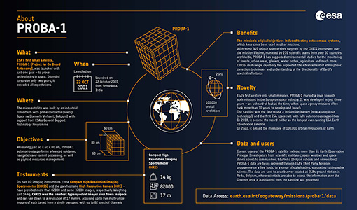
PROBA-1 - From technology demonstration to long-term Earth observation
Learn about ESA's PROBA-1 (Project for On-Board Autonomy) mission in our new infographic.
Mission - Third Party Missions
PROBA-1
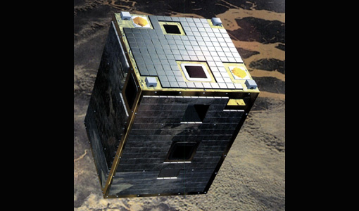
PROBA-1 is a technology demonstration satellite that later became an operational Earth observation mission.
Document - General Reference
Overview of an Intelligent Sensorweb for Integrated Earth Sensing Project
Document - General Reference
On-the-Potential-of-CHRIS-PROBA-for-Estimating-Vegetation-Canopy-Properties-from-Space.pdf
On the Potential of CHRIS/PROBA for Estimating Vegetation Canopy Properties from Space.
Document - Technical Note
Note on CHRIS Acquisition Procedure and Image Geometry
The aim of this document is to clarify the acquisition procedure CHRIS on-board the PROBA satellite. It provides a detailed description of the acquisition procedure and summarises the implications for the geometrical properties of the CHRIS images.
News - Success Stories
New cross-calibration readies PROBA-1 data for climate research
While PROBA-1 has already exceeded expectations by suppling over 21 years of Earth observation hyperspectral data, recent cross-calibration activities are aiming to ensure the data will robustly serve long time-series research, even when the satellite ends operations.
Document - Product Document
Leaf-area-index-from-CHRIS-satellite-data-and-applications-in-plant-yield-estimation.pdf
This paper focuses on the optical remote sensing aspects of the ISIES project.
Document - Proceedings
Hyperspectral Workshop 2010
Proceedings of the Hyperspectral Workshop 2010 held on 17-18 March 2010 in ESA-ESRIN, Frascati, Italy. This workshop was organised by the European Space Agency (ESA), the German Aerospace Center (DLR)/the German Research Center for Geosciences (GFZ) and the Italian Space Agency (ASI).
Document - Product Readme Note
Fine-Resolution-Air-Quality-Monitoring-from-a-Small-Satellite-CHRIS-PROBA.pdf
This paper was published in "Sensors" and demonstrates the ability of the European Space Agency's small satellite sensor CHRIS/PROBA to provide reliable AOT estimates at a spatially detailed level over Hong Kong, using a modified version of the dense dark vegetation (DDV) algorithm devised for MODIS.
Activity - Quality
EDAP
The ESA Earthnet Data Assessment Pilot (EDAP) project will perform assessments for various missions to ensure the delivered data is fit for purpose.
Document - General Reference
Earth-from-Space-South-America.pdf
This brochure is a collection of Envisat MERIS, Envisat ASAR and PROBA CHRIS mosaics of South America. The attached CD-rom contains the same images in electronic version.
Document - General Reference
Earth-from-Space-Russia-and-Ukraine.pdf
This brochure is a collection of KOMPSAT EOC; ERS-2 SAR; Envisat ASAR, MERIS and Proba CHRIS, HRC mosaics.
Document - General Reference
Earth-from-Space-Deserts.pdf
This brochure is a collection of Envisat MERIS, Envisat ASAR, Proba and Landsat mosaics of desert areas on our planet.


