- All Categories (27)
- Data (1)
- News (2)
- Events (3)
- Tools (1)
- Activities (1)
- Campaigns (1)
- Documents (18)
Event - Training
EO Summer School 3
ESA's series of summer schools, on Monitoring of the Earth System, aims to promote the exploitation of Earth observation data.
Event - Conference
Living Planet Symposium 2022
Learn about the 2022 edition of ESA's Living Planet Symposium.
News - Thematic area articles
Satellite data central to ocean monitoring
Over 95% of Earth’s water is found in our oceans, and yet sadly, oceans are under stress from climate change and pollution. Monitoring our oceans is vital for Earth’s survival and satellites are the primary means of long-term and independent observation of our vast ocean bodies and their associated coastal zones.
Tools - Other
Hydrology TEP
The Hydrology Thematic Exploitation Platform (TEP) enables access, processing, uploading, visualisation, manipulation and comparison of hydrological data.
Document - General Reference
Shrimp farm inventory and monitoring
This series produced by the Environment and Natural Resources Service of FAQ aims to present the possibilities of remote sensing techniques for natural resource management and planning.
Data - Campaigns (Open)
BACCHUS-DOC
The BACCHUS-DOC Radar and Optical Campaign was an area mapping project of vineyards near Frascati (Italy). ESA required high resolution geo-referenced airborne SAR data of different wavelength and polarisation (preferably polarimetric).
Campaign
BACCHUS-DOC
The BACCHUS-DOC Radar and Optical Campaign was an area mapping project of vineyards near Frascati (Italy). ESA required high resolution geo-referenced airborne SAR data of different wavelength and polarisation (preferably polarimetric).
Activity - Quality
EDAP
The ESA Earthnet Data Assessment Pilot (EDAP) project will perform assessments for various missions to ensure the delivered data is fit for purpose.
Document - Technical Note
34th AATSR QWG Meeting Summary
The 34th AATSR QWG Meeting was held on 28th/29th March 2017 at RAL, Harwell, U.K. ThisMemorandum states the objectives of the Meeting, gives a selected highlight, and summarisesthe discussions that took place.
Document - Proceedings
Dragon Programme Mid-Term Results
Proceedings of the 2005 Dragon Symposium held on 27 June - 1 July 2005 in Santorini, Greece.
Document - Technical Note
(A)ATSR Expert Support Laboratory FAST Level 1b Product Definition
(A)ATSR Expert Support Laboratory FAST Level 1b Product Definition.pdf
Event - Conference
Living Planet Symposium 2019
ESA's Living Planet Symposia are amongst the biggest Earth observation conferences in the world. Scientists present their latest findings on Earth's environment and climate.
News - Success Stories
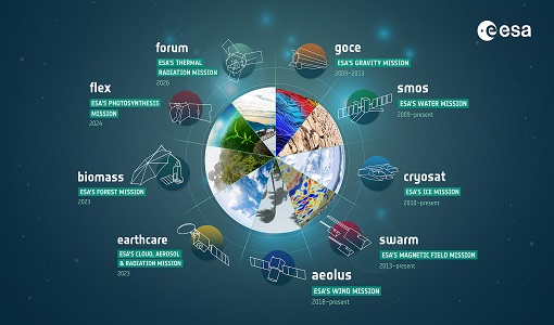
ESA's Earth Explorers surpassing expectations
In this video, learn how each Earth Explorer mission is contributing to Earth science, and changing the way we look at our beloved planet.
Document - General Reference
Earth-Observation-from-Space-supporting-Biodiversity-Conservation.pdf
This brochure provides an overview of the ESA-funded Diversity project, which aims to demonstration the contribution Earth observation makes towards monitoring the trends and status of different marine and terrestrial ecosystems relevant to diversity.
Document - General Reference
Earth-Observation-Applications-for-the-Aquaculture-Industry.pdf
This flyer describes the applications of Earth Observation for aquaculture, specifically the Harmful Algal Bloom (HAB) system of Hatfield Consultants Ltd.
Document - General Reference
Earth-from-Space-Middle-East.pdf
This brochure is a collection of ENVISAT ASAR and MERIS, PROBA, ERS-2, Landsat mosaics.
Document - General Reference
Earth-from-Space-Oceans-and-Coastal-Zone.pdf
This brochure is a collection of ERS-2 SAR; ENVISAT ASAR, MERIS, AATSR; Landsat TM and Proba CHRIS mosaics.
Document - General Reference
Earth-Observation-Services-Today-Using-Radar-from-Space.pdf
This booklet provides descriptions of EO services available today from specialist providers for the marine environment e.g. CLS (Collecte Localisation Satellites] and NERSC (Nansen Environmental and RemoteSensing Centre], Ocean Numerics, ARGOSS, MeteoMer and Satellite Observing Systems (SOS].
Document - General Reference
Healing-the-Earth-Earth-Observation-Supporting-International-Environmental Conventions.pdf
This article is extracted from ESA Bulletin Nr. 128.
Document - General Reference
Medspiration-A-Precursor-to-the-GMES-Marine-Core-Service-Sea-Surface-Thematic.pdf
This is an article extracted from the ESA Bulletin Nr. 132.


