- All Categories (9)
- Data (1)
- News (6)
- Events (2)
Event - Conference

15 Years of Progress in Radar Altimetry Symposium
A Symposium on "15 Years of Progress in Radar Altimetry" and the annual meeting of the Ocean Surface Topography Science Team, the International Doris Service Workshop and the ARGO Workshop.
News - Infographics

An overview of ESA's Third Party Missions programme
ESA’s Third Party Missions programme consists of almost 50 satellite missions, which are owned by organisations around the world. ESA has agreements with these organisations to acquire, process, and distribute data from their missions
News - Infographics

An overview of the very high-resolution WorldView constellation
Learn about the WorldView constellation, part of ESA’s Third Party Missions programme, in this infographic.
Event - Workshop

Coastal and Marine Applications of SAR Workshop 2003
The second in the Coastal and Marine Applications of SAR Workshop series covered a range of topics on applications of synthetic aperture radar (SAR) in coastal and marine environments.
News - Events and Proceedings

Highlights from Living Planet Symposium
As remote sensing scientists and data-users from around the world converged at the Living Planet Symposium (LPS) in Bonn recently, a common thread was evident in many scientific sessions and meetings – the right environmental data can accelerate our understanding of the rapid changes in Earth’s system.
News - General News

Satellite Radar Altimetry: past and future
Satellite radar altimetry measurements yield a wealth of information that can be used for a wide range of applications.
Data - EO Sign In Authentication (Open)
SeaSat ESA archive
This collection gives access to the complete SEASAT dataset acquired by ESA and mainly covers Europe. The dataset comprises some of the first ever SAR data recorded for scientific purposes, reprocessed with the most recent processor. The Level-1 products are available as: SAR Precision Image [SEA_PRI_1P] SAR Single Look Complex Image [SEA_SLC_1P] SAR Ellipsoid Geocoded Precision Image [SEA_GEC_1P] Spatial coverage: Check the spatial coverage of the collection on a map available on the Third Party Missions Dissemination Service.
News - Success Stories

WorldView-3 helps to track offshore methane plumes from oil and gas
Scientists have used Earth observation data to reveal enormous methane plumes spilling out from an offshore oil and gas production rig in the Gulf of Mexico. This represents a significant breakthrough in the monitoring of industrial methane emissions from space.
News - Success Stories
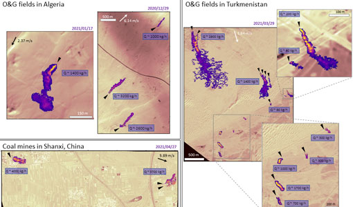
WorldView-3 satellite maps methane plumes at very high spatial resolution
Substantial advances have been made in the last years towards the detection and quantification of methane emissions from space- very high spatial resolution data from the WorldView-3 satellite can fill an important observational gap in the remote sensing of methane point emissions.