- All Categories (36)
- Data (2)
- News (14)
- Missions (3)
- Events (7)
- Tools (2)
- Activities (1)
- Documents (7)
Document - Conference Presentation - Poster

4_POLinSAR2013_Ban_KTH.pdf
Multitemporal RADARSAT-2 Fine-Beam Polarimetric SAR for Urban Land Cover Mapping Y. Ban [KTH Royal Institute of Technology - Sweden]
Document - Conference Presentation - Poster
5_polinsar_Koeniguer.pdf
PolSARAP: Investigating the Benefits of Polarimetry for Urban Applications using X-Band SAR Images E. Koeniguer [ONERA - France]
Document - Conference Presentation - Poster
6_pres_polinsar_azzal.pdf
Analysis of a NLOS Canyon in an InSAR Image of a Urban area at KA-BAN A. Mokadem [Supelec - France]
Document - Conference Presentation - Poster
6_TROUVE_polinsar_2013_hybrid.pdf
Hybrid PolInSAR: High resolution & Polarimetry Applied to Urban N. Trouve [ONERA - France]
Document - Conference Presentation - Poster
7_POLinSAR2013_recommendations_land_applications.pdf
Applications of SAR Polarimetry on Land: Agriculture, Urban, Archaeology
Document - Conference Presentation - Poster
9_ApplicationsOfSARPolarimetry_Other.pdf
Session - Applications of SAR Polarimetry: Other
Event - Training

9th Advanced Training Course on Land Remote Sensing
ESA organised the 9th Advanced Training Course on Land Remote Sensing with a focus on Agriculture. It took place from 16 to 20 September 2019.
News - Infographics
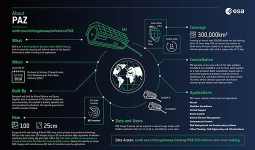
An overview of the PAZ SAR satellite mission
Learn more about the PAZ mission, a Spanish X-Band SAR satellite and part of ESA's Third Party Missions programme, in our latest infographic.
News - Infographics
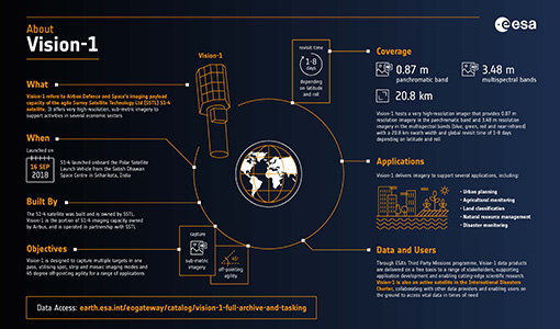
An overview of the very high-resolution Vision-1 satellite
Learn about Vision-1, which joined ESA's Third Party Missions programme in May, in our new infographic.
Data - Announcement of Opportunity (Restrained)

Announcement of Opportunity for NoR
ESA invites submissions for the Network of Resources (NoR) call, which aims to support research, development and pre-commercial users to innovate their working practices, moving from a data download paradigm towards a 'bring the user to the data' paradigm.
Event - Workshop

Aquaculture User Consultation
The main goal of the workshop was to define a detailed set of user requirements for the future ESA Aquaculture project.
Mission - Third Party Missions

COSMO-SkyMed Second Generation
COSMO-SkyMed Second Generation is at the forefront of radar technology, will ensure improvements and guarantee continuity with the First Generation CSK satellites, preserving the high quality and the highest precision features, both required for the interferometric activities.
Document - Newsletter

Earth Online Newsletter 01 December 2023
This issue of the Earth Online Newsletter covers a selection of the latest news and events from ESA.
Event - Training

EO Summer School 8
ESA's series of summer schools, on Monitoring of the Earth System, aims to promote the exploitation of Earth observation data.
Activity - General activities
EO Summer Schools
ESA's series of summer schools, on Monitoring of the Earth System, aims to promote the exploitation of Earth observation (EO) data.
Event - Meeting

Fluorescence (FLEX) 2019
The FLEX 2019 meeting consisted of a series of events addressing remote sensing of vegetation fluorescence.
Tools - Other

Food Security TEP
The Food Security Thematic Exploitation Platform (TEP) enables access, processing, uploading, visualisation, manipulation and comparison of data related to food security.
News - Success Stories

Heritage data still widely used today
For about 30 years now, ESA satellites have been cruising some 800 km above our heads, collecting information about our planet-but why are older missions still so fundamental today?
News - Thematic area articles
How satellite data empower sustainable urban growth
Earth observation is a vital tool for facilitating the sustainable development of the world's cities, helping to ensure that urban centres keep spurring collaboration, innovation and opportunity as they continue to expand.
News - Thematic area articles

How satellite data help to shape society
Data from ESA’s Earth observation archives are improving understanding of the interactions between human activities and the environment, helping to power green economic development and boosting prosperity in Europe and beyond.