- All Categories (89)
- Data (11)
- News (39)
- Missions (4)
- Events (14)
- Tools (1)
- Activities (1)
- Campaigns (6)
- Documents (13)
News - Events and Proceedings

Φ-Week Triumphs
In its fourth edition, Φ-Week presented the scientific community with amazing opportunities and projects—thus running alongside innovation at 360 degrees.
News - Success Stories
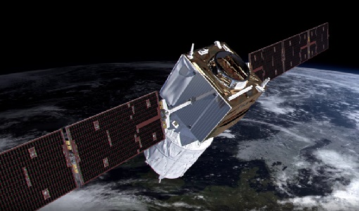
Young scientists bid farewell to ESA's wind mission
Students and early career researchers are saying an emotional goodbye to Aeolus ahead of its upcoming reentry.
Campaign
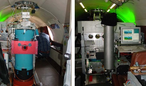
WindVal II
The objectives for the WindVal II campaign in 2016 were derived from the results, experience and lessons learnt from these last airborne campaigns in 2009 and 2015.
Campaign
WindVal I
The objectives of the WindVal 1 campaign in 2015 were derived from results, experience and lessons learnt from the previous airborne campaign in 2009.
News - Infographics
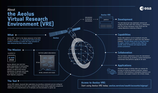
What is Aeolus VRE?
Learn more about the the Aeolus Virtual Research Environment (VRE), the latest extension to the VirES for Aeolus service, in this infographic.
News - Infographics

What are the next Earth Explorers?
Learn about the planned missions in the Earth Explorers programme - EarthCARE, Biomass, FLEX, and FORUM - which will further our understanding of Earth’s climate.
Campaign
WALEX
The objective of the airborne campaign Water Vapour Lidar Experiment (WALEX) is to collect valuable data to provide representative lidar measurements of water vapour and aerosol properties in different climatic zones.
Data - Campaigns (Open)
WALEX
The objective of (WALEX) was to collect valuable data to provide representative lidar measurements of water vapour and aerosol properties in different climatic zones.
News - Infographics
The JATAC campaign - Supporting ESA's Aeolus mission
A new infographic has been released for the Joint Aeolus Tropical Atlantic Campaign (JATAC).
News - Operational News
The divine keeper of the winds retires
ESA’s fifth Earth Explorer - Aeolus - is due to retire soon, but will provide fully nominal data up to the end of operations on 30 April.
Event - Workshop

The 1st workshop of ACIX-III Land, Aqua and CMIX-II
The 1st workshop of ACIX-III Land, Aqua and CMIX-II will be held on 20-21 June 2022 in ESA/ESRIN (Frascati, Italy), where coordinators and participants will discuss and define the implementation protocols.
News - Operational News

Temporary interruption to Envisat AATSR dissemination service
A planned downtime will affect the access to the ftp dissemination server for the Envisat AATSR data during the period 13-15 February 2024.
News - Events and Proceedings
Submit your abstracts for EarthCARE Pre-Launch Science and Validation Workshop
Invitations are now open for the EarthCARE Pre-Launch Science and Validation Workshop, which will take place at ESRIN in Frascati, Italy, from 13 to 17 November.
News - Success Stories

Ship trails in the Bay of Biscay observed using PROBA-V imagery
Ship trails have been perceived as convincing evidence of aerosol-cloud interaction. Ship emissions have been proven to contribute by about 1.9% and 2.9% to the increase in the global total and fine-mode aerosol optical thickness (AOT) respectively over a five year period (Peters et al. 20212).
News - Events and Proceedings
Scientists to showcase value of Earth observation data at EGU
Remote sensing scientists are getting ready to present innovative and exciting applications of satellite data at the European Geosciences Union general assembly which will take place from 24 to 28 April in Vienna, Austria.
News - Data Release news
PROBA-V ‘Collection 2’ - Reprocessed Dataset available
The improved PROBA-V data (Collection 2) has been released. Data is available via the PROBA-V MEP and Terrascope platforms so users can freely exploit the data using Virtual machines, Jupyter Notebooks, and the new viewing application.
News - Success Stories
PROBA-V data improve surface albedo products in Africa
As ESA’s PROBA-V satellite marks its 10-year launch milestone, data tasked during the mission’s lifetime are still being used to assess changes in land cover.
Event - Meeting

Proba-V Cloud Detection Round Robin Meeting
A Round Robin exercise aimed at the inter-comparison of different cloud detection algorithms for Proba-V has been organised by the European Space Agency (ESA) and the Belgian Science Policy Office (BELSPO).
Data - External Data (Restrained)
PROBA-V 1 km, 333 m, and 100 m products
The PROBA-V VEGETATION Raw products and Synthesis products provided coverage of all significant landmasses worldwide with, in the case of a 10-day synthesis product, a minimum effect of cloud cover, resulting from selection of cloud-free acquisitions during the 10-day period. It provided a daily coverage between Latitudes 35°N and 75°N, and between 35°S and 56°S, and a full coverage every two days at the equator. The VEGETATION instrument was pre-programmed with an indefinite repeated sequence of acquisitions. This nominal acquisition scenario allowed a continuous series of identical products to be generated, with the goal to map land cover and vegetation growth across the entire planet every two days. Level Synthesis Resolution resolution (m) Reflectance Level-1C n/a TOA Level-2A n/a 100 m TOA 333 m TOA 1 km TOA Level-3 S1 100 m TOA TOC TOC NDVI 333 m TOA TOC 1 km TOA TOC S5 100 m TOA TOC TOC NDVI S10 333 m TOC TOC NDVI 1 km TOC TOC NDVI Raw Products Overview Product Description Level-1C Level-1C segments (P – product): Radiometrically corrected Level-1B data, in raw sensor geometry (unprojected) Contains: - Top Of Atmosphere reflectance in the four spectral bands - Longitude/latitude information for every pixel - Geometric viewing conditions - Information on the status map (indicating missing and interpolated measurements). Format: HDF5 & GeoTiFF Level-2A Level-2A segment: projected Level-1C (P–product) data, radiometrically and geometrically corrected. Contains: - TOA reflectance values in the four spectral bands without atmospheric correction being performed - Information on the status map (containing identification of radiometric quality, snow, ice, shadow, clouds, land/sea for every pixel) - Geometric viewing conditions Plate carrée projection (EPSG:4326) with spatial resolution of 100 m, 333 m and 1 km Format: HDF5 & GeoTiFF Synthesis Products Overview Level-3 S1 = daily, S5 = 5 days, S10 = decade Different spatial resolution: 100 m, 333 m and 1 km Divided into so called granules, each measuring 10 degrees x 10 degrees, each granule being delivered as a single file Plate carrée projection (EPSG:4326) Format: HDF5 & GeoTiFF Products Content TOA - Top Of Atmosphere reflectance in the four spectral bands (no atmospheric correction applied) - Normalized Difference Vegetation Index (NDVI) -Information on the composite status map (containing identification of snow, ice, shadow, clouds, land/sea for every pixel) - Geometric viewing conditions & date and time of selected measurement TOC Level-2A segment: projected Level-1C (P–product) data, radiometrically and geometrically corrected. Contains: - Top Of Canopy (ground surface) reflectance in the four spectral bands, the atmospheric correction being performed using the SMAC (Simplified Method for Atmospheric Corrections) algorithm - Normalized Difference Vegetation Index (NDVI) - Information on the composite status map (containing identification of snow, ice, shadow, clouds, land/sea for every pixel) Normalized Difference Vegetation Index (NDVI) from Top Of Canopy product (SMAC algorithm for atmospheric corrections applied) - Geometric viewing conditions & date and time of selected measurement TOC NDVI Normalized Difference Vegetation Index (NDVI) from Top Of Canopy product (SMAC algorithm for atmospheric corrections applied)
Mission - Earth Watch

PROBA-V
The PROBA-V mission provides multispectral images to study the evolution of the vegetation cover on a daily and global basis.