- Learn & Discover
- Pléiades unlocks information a...
Pléiades unlocks information about rock glaciers in central Himalaya
17 Jan 2023
As climate change accelerates the melting of glacial ice, remote sensing scientists are tapping into the potential of Pléiades data to help vulnerable mountainous communities.
High Mountain Asia (HMA) has the largest volume of glacier ice in mid-latitude regions and is seen as the water tower of Asia.

As climate change raises Earth’s temperatures, the loss of glacial ice jeopardises drinking and irrigation water for millions of people in and beyond these mountainous regions.
However, the contribution of water trapped in rock glaciers is often under looked.
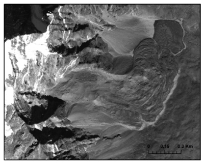
New research leveraging the very high resolution (VHR) data from the Pléiades mission has successfully mapped glaciers, rock glaciers, glacial lakes and their changes in the Poiqu River basin, in central Himalaya, over six decades [1].
Funded by ESA as part of the Dragon-4 project, the overall objective of the research was to study changes in the cryosphere in HMA.
“One of our aims was to generate a consistent rock glacier inventory for the Poiqu basin using freely available very-high-resolution Pléiades images,” says lead researcher, Tobias Bolch, at the School of Geography and Sustainable Development, University of St Andrews, UK, currently at the Institute of Geodesy, TU Graz, Austria.
Significant amounts of water in HMA are in the form of rock glaciers – landforms rich in ice, created by the viscous creep of perennially frozen angular rocks in permafrost environments.
Bolch explains, “Rock glaciers have core ice but are completely covered by rock as they creep slowly downslope. They are typically quite small and can be confused with landslide deposits or the frontside of debris-covered glaciers, which is why we needed very high-resolution data - such as that from Pléiades - to identify them.”
The Pléiades programme is a forerunner in providing VHR commercial satellite imagery, ideal for precision mapping and in-depth intelligence. It is an ESA Third Party Mission (TPM) built and operated by Airbus Defence and Space on behalf of CNES. For scientific purposes, ESA enable free access to these remote sensing data.
Since rock glaciers have a thick debris layer, they are more resilient to ice melt as our planet warms. Usually, as glaciers recede, rock glaciers remain stable.
However, as atmospheric temperatures increase further, even the ice core of rock glaciers can melt – providing a further source of water, which is not considered in current hydrological models.
The research group mapped glacier elevation changes using historical multi-temporal stereo satellite imagery from the 1960s (Corona and Hexagon images), as well as the contemporary VHR Pléiades data.
“Our elevation maps show that when glaciers are losing mass, they are on the one hand retreating, which means they get shorter and on the other hand, thinning, or losing ice. The observed mass loss correlated well to measured temperature increase in the region.” says Bolch.
There are complex downstream impacts of ice melt on the communities of HMA. Runoff water from glacial ice melt is an important source of water for these communities and may become scarce as glaciers lose mass.
Since rock glaciers melt later than glaciers, their runoff may help counterbalance the decrease in run off from glaciers.
Bolch adds, “We don’t really know enough about the whereabouts and ice content of rock glaciers to fully understand how they may contribute to water resources in the region - which motivated this research.”
The high resolution of Pléiades data - with a resolution of 0.5 m in panchromatic band – enabled the researchers to generate very precise elevation models of about 2 m.
In preliminary studies they showed the suitability of the data to feature elevation changes in the order of tens of centimetres, to help track the slow creep of rock glaciers.
References
[1] Bolch et al, “Earth Observation to Investigate Occurrence, Characteristics and Changes of Glaciers, Glacial Lakes and Rock Glaciers in the Poiqu River Basin (Central Himalaya)” Remote Sens. 2022, 14, 1927 13 of 18. https://doi.org/10.3390/rs14081927.