- Learn & Discover
- ESA’s wind mission could help ...
ESA’s wind mission could help to forecast tropical storms
27 Oct 2022
Global wind profiles delivered by Aeolus have great potential to improve the projections of a long-established hurricane forecasting system developed in the US, according to science published in a leading meteorological journal.
The assimilation of Aeolus observations into the model was shown to be very effective in regions not covered by targeted reconnaissance aircraft that are dispatched to gather wind data for selected storms.
The study represents another exciting result for Aeolus, a mission that has continued to outstrip its original objectives since its launch in 2018.
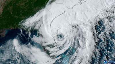
Several damaging storms over the past weeks have served as a reminder of the destructive nature of tropical cyclones.
These include Hurricane Ian – which made landfall in Florida – and Hurricane Orlene, which hit Mexico’s Pacific coast. Another cyclone – called Typhoon Noru – caused extensive damage in the Philippines.
Given the threat these storms pose to people’s lives and vital infrastructure, the improvement of forecasting systems is an important focus of research.
The Hurricane Weather Research and Forecasting (HWRF) model – developed by the US National Oceanic and Atmospheric Administration (NOAA) and its partners – draws on data from several sources, including satellites, buoys, and reconnaissance aircraft.

The system – which became operational in 2007 – uses simplified equations that represent physical processes to deliver projections on the tracks and intensities of tropical storms. It is also used to support atmospheric research.
Information on winds delivered by weather balloons, satellites, and aircraft has been shown to improve its projections; however, the wind data currently assimilated into the model are often patchy and incomplete.
Targeted reconnaissance flights – which provide essential information on winds for tropical cyclone forecasting – are only deployed in response to certain storms in the Atlantic, and typically do not cover other regions, such as the Pacific and Indian Oceans.
In addition, other wind observations that are used in HWRF are only provided at specific heights, rather than complete vertical profiles.
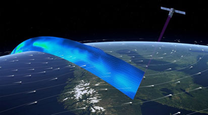
Part of ESA’s Earth Explorers programme, Aeolus addresses the need for more comprehensive data on movements in the atmosphere by providing global information on winds in the form of vertical profiles.
The mission uses one sensor – called the Atmospheric Laser Doppler Instrument (ALADIN) – to determine the speed and direction of the wind in the lowermost 30 km of the atmosphere.
These data are already being used by many meteorological centres across the world to inform better weather predictions.
As part of the research – which was published in the Quarterly Journal of the Royal Meteorological Society – scientists completed a series of observation system experiments to examine the impact of assimilating Aeolus data into HWRF.
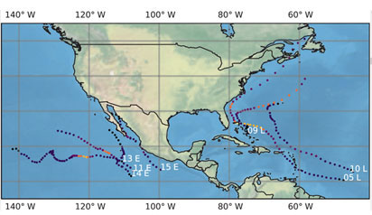
The study focused on the full cycles of seven tropical cyclones, which consisted of a total of 226 individual 126-hour forecasts. The storms were located in the Atlantic and Eastern Pacific oceans, taking place in 2019.
Researchers found that winds observed by Aeolus were consistently stronger than the winds estimated by HWRF. This finding helped them investigate the differences between the observations and modelling system, assisting in the interpretation of the research.
They also demonstrated that the greatest potential impacts from the assimilation of Aeolus observations were likely to occur in the upper troposphere and lower stratosphere and within about 500 km of the centre of the tropical cyclone.
Importantly, the integration of Aeolus data was most effective when reconnaissance aircraft data were unavailable and during the early stages of the tropical cyclone’s development.
Since reconnaissance aircraft data are typically only available for selected storms in the Atlantic Ocean, Aeolus may have the largest positive impacts on tropical cyclone prediction in the Pacific and Indian Oceans.
Peter Marinescu, Research Scientist at Colorado State University and lead author of the study, said: “Wind observations from platforms like Aeolus can improve the forecasting of tropical cyclones, especially in parts of the globe that do not have dedicated resources providing observations within these storms, such as those from NOAA’s Hurricane Hunter flights.
“This is the first study that looks at the impacts of Aeolus in a regional hurricane model. As we continue to better understand the Aeolus observations, additional forecast testing with even larger sample sizes can allow us to further improve how these observations are used in models.”
References:
Marinescu, P.J., Cucurull, L., Apodaca, K., Bucci, L. & Genkova, I. (2022) The characterization and impact of Aeolus wind profile observations in NOAA’s regional tropical cyclone model (HWRF). Quarterly Journal of the Royal Meteorological Society, 1–18. Available from: https://doi.org/10.1002/qj.4370