- News
- Charter on major disasters cel...
Charter on major disasters celebrates 20 years of operations
20 Oct 2020
Founded by ESA and the French and Canadian space agencies in 2000, the International Charter Space and Major Disasters is a collaboration between agencies that have been contributing satellite, data processing and data distribution assets for the last 20 years.
Today, the Disasters Charter is a worldwide collaboration of 17 members – most of which are space agencies – and 67 countries have direct access to the Charter through Universal Access. It aims at providing a unified system of space data acquisition and delivery to those affected by natural or man-made disasters through Authorised Users.
It supports the most common forms of natural disasters such as floods, earthquakes, landslides, cyclones and so on, but there are other types of disasters, which also benefit from satellite observations. These can be technological disasters, which may occur in the event of a train or aircraft crash, or an accident at a factory, power plant or other large scale infrastructure; or it can be used to help in the search for missing ocean-going vessels or aircraft, although this is extremely challenging.
Each member has committed resources to support the provisions of the Charter and thus is helping to mitigate the effects of disasters on human life and property.

Satellite imagery enable decision-makers, rescue teams and responders to reach victims quickly, move them to safety and select the best locations for rescue efforts.
Major Charter response efforts include the massive 7.9 magnitude earthquake in Nepal of 2015; the devastating Typhoon Haiyan in the Philippines in 2013; Haiti's 2010 earthquake; the tragic Deepwater Horizon oil spill in the Gulf of Mexico in 2010; the tsunami in Indonesia and Thailand in 2004; and other major disasters across the globe.
Some of the Charter's major activations have involved the Copernicus Sentinel satellites.
The EU-funded Copernicus Emergency Management Service – which provides maps free of charge to civil protection agents - cooperates with the Charter in order to avoid duplication, thus ensuring maximum assistance to victims. The maps produced by both services highlight the impact of international disasters and serve as a valuable resource for damage assessment efforts.
In 2017, the International Charter for Space and Major Disasters Team received the prestigious William Thomas Pecora Award for its 'outstanding support to the global community during times of crisis', providing free satellite imagery, data and information to the global community during times of crises.
One of the most recent industrial accidents that the Charter responded to, is the explosion that occurred in the Port of Beirut, capital city of Lebanon, at 15:08 UTC on 4 August, 2020.
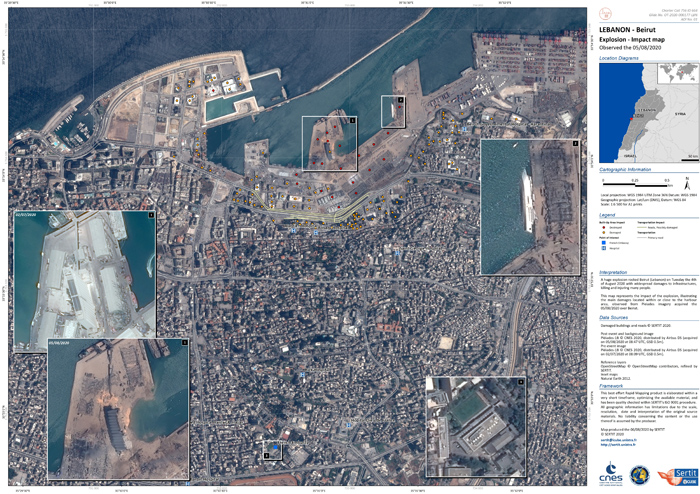
Caused by the explosion of a large quantity - 2,750 tons - of ammonium nitrate at a warehouse in the port, the explosion damaged half of Beirut and killed at least 190 people, leaving 300,000 homeless.
It was so powerful, that the United States Geological Survey registered it as a 3.3 magnitude earthquake. France (Centre Opérationnel de Gestion Interministérielle des Crises) activated the Charter on 5 August. Satellite imagery acquired after the explosion showed a large crater where the warehouse had been and revealed damage to the port area. The Orient Queen, a cruise ship that was docked in port, was badly damaged and capsized on 5 August.
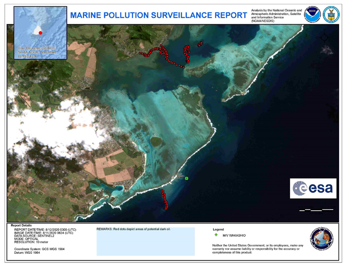
Other types of technological disasters that the Charter responded to include the recent oil spills in Mauritius (August 2020) and Russia (June 2020), two dam collapses in Brazil (January 2019 and November 2015), and the well-known Deepwater Horizon oil spill in the Gulf of Mexico (2010), which was also covered in a retrospective Charter article on the 10th anniversary of the disaster in April 2020.
With 61 contributing satellites, the Charter has been activated over 680 times in 126 countries to date, and operates 24/7 to aid rescue and relief efforts worldwide.
ESA was one of the founding members of the Charter in 1999. Since its inception, ESA has conducted the role of Primus Inter Pares a total of six times, the last one being over the period from October 2017 to April 2018. In this position, one of the Charter members takes on the lead role of the Charter for six months, and is responsible for coordinating the overall activities of the Charter during that time.
ESA contributes in the Charter with the Copernicus Sentinel-1 and Sentinel-2 missions, and in the past also contributed data from the ERS, Envisat, and PROBA-V satellites. ESA also provides the 24/7 On Duty Officer (ODO) role for the reception of calls for activation, Emergency on-Call Officers (ECO) on a weekly rotation with other Charter members, and on a best effort basis Project Managers (PM) responsible for Charter activations.
Furthermore, ESA has developed and operates the data workflow management system – the Charter Operations System (COS) - which is the backbone of its operations on an emergency basis with the Charter operational staff and its partners and Authorised Users during activations.