- Data
- Envisat DORIS Precise Orbit [D...
Envisat DORIS Precise Orbit [DOR_VOR_AX]
Navigate To
How to Access Data
Fast Registration with Immediate Access (Open)
- Go to the ESA User Services Portal
- Register or log in to EO Sign In
- Submit the form for accessing the data
- You will receive an email with your user name
- A second email will follow with your password to download the data from the envorb-ftp-ds.eo.esa.int server via an FTP client (see Read More for connection details) or, alternatively, from command line using L-FTP.
The data can be downloaded via an FTP client (e.g., FileZilla or WinSCP) using the options "explicit FTP over TLS if available" or "Require explicit FTP over TLS".
See DORIS products availability table.
For further information about the EO Sign In Service you can visit TellUs.
Should you need support to access the data, please contact EOHelp.
Collection Description
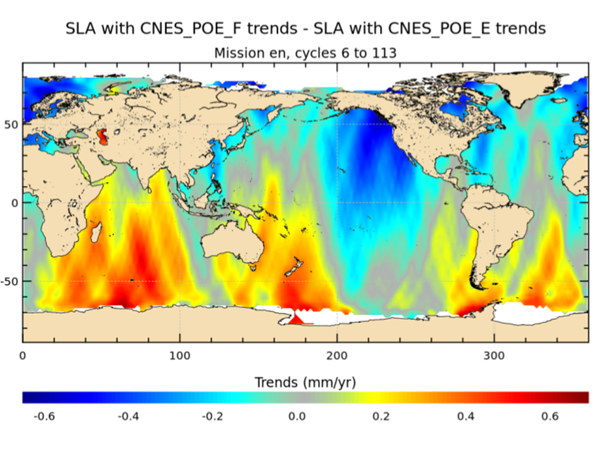
The latest version of the Envisat DORIS Precise Orbit product, DOR_VOR_AX, was generated by the Centre de Traitement Doris Poseidon (CTDP) using the Geophysical Data Records F standards (GDR-F). The product is used to obtain the satellite orbital parameters (latitude, longitude, height and height rate) by using orbit computation routines.
The most significant changes related to the GDR-F standards concern the new ocean tide model (FES2014) and the updated Terrestrial Reference Frame (ITRF2014). The new standards significantly improve all Precise Orbit Determination (POD) metrics with respect to GDR-E. The mean difference and variance of Sea Surface Height (SSH) at crossovers is slightly reduced.
The DOR_VOR_AX product adopts the Envisat format, and the size is 0.2 Mbytes per orbit.
Users are recommended to apply the GDR-F version, but the previous datasets are still available (i.e. GDR-D and GDR-E versions).
See further details in the readme file for Envisat DORIS Precise Orbit Determination files.
Technical Details
DATA SET SPECIFICATIONS
- European Space Agency, 2021, Envisat Precise Orbit product - GDR Version F.https://doi.org/10.5270/ESA-6615b19
- European Space Agency, 2019, Envisat Precise Orbit product - GDR Version E.https://doi.org/10.5270/EN1-6d4a63e
PROCESSING LEVEL
APPLICABLE TERMS & CONDITIONS
DATA CITATION
Having Problems Accessing Data?
Resources
Discover Latest Data
Announcement of Opportunity for Spire data
ESA is launching an Announcement of Opportunity for the international scientific community to access data from the Spire mission for science...
ERS ATSR L1B Brightness Temperature/Radiance [ER1_AT_1_RBT / ER2_AT_1_RBT]
Band measurements with associated uncertainty estimates. The ERS-1/2 ATSR Level 1B Brightness Temperature/Radiance products (RBT) contain to...
TomoSense
The TomoSense experiment was conceived to provide the scientific community with unprecedented data to study the features of radar scattering...
WIVERNex-UK
This campaign was designed to extend the Chilbolton ground measurement record that involved analysis of radar observations made by the 94 GH...