|
Tunis, Tunisia (1984-2004)
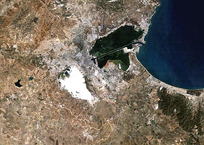
Twenty years separate these two Landsat thematic mapper images of Tunis, Tunisia. They highlight the urbanisation and expansion that the city has undergone during the course of these twenty years by allowing a comparison between the 2004 image on the right and the 1984 image on the left. To the top right of both of the images, the subsidiary port of Halq al Wadi (La Goulette), which gives access to the Gulf of Tunis, can be seen. Tunis is divided into three parts, the old city, called Medina; the French city, which now is the centre; and the newer and larger regions built in the south and the north of the city. Tunis is the commercial and economic centre for northern Tunisia, and the administrative centre for the whole of Tunisia. The ruins of Carthage can be seen in the northeast. The famous Festival of Carthage is held there each year. The ruins of the ancient city are on the peninsula in the Bay of Tunis and near modern Tunis. The Latin name, Carthago or Cartago, was derived from the Phoenician name, which meant "new city". Comparing the grey-white area to the centre of the two images, you can see the explosion of the modern town of Tunis. According to Tunisia's National Statistical Institute, Tunisia's urban population grew from 4.86 million on 1990 to 6.20 million in 2002, an increase of around 28%. The black X shape pattern northwest of Tunis is the city's airport. The oval shape on the 1984 and 2004 image is the Sebkhet Sejoumi salt lake. The lake is intermittent and the salt content can be clearly seen in the dry lake in the 1984 image. The first Landsat-5 image was acquired on 11 July 1984 – This Landsat Thematic Mapper image shows Tunis, the capital city of Tunisia, as it was in 1984. Tunisia became a centre of Arab culture and learning and was assimilated into the Turkish Ottoman Empire in the 16th century. It was a French protectorate from 1881 until independence in 1956, and retained close political, economic, and cultural ties with France. The ruins of Carthage can be seen in the northeast. The famous Festival of Carthage is held there each year. To the top right of both of the image, the subsidiary port of Halq al Wadi (La Goulette),which gives access to the Gulf of Tunis, can be seen. The Sebkhet Sejoumi salt lake can be seen in this image, the lake is oval shaped, and the dry salt content is clearly visible. The black X shape pattern northwest of Tunis is the city's airport. The second Landsat-5 image was acquired on 02 July 2004 – Tunis, the capital city of Tunisia, currently has a population of about 1.3 million inhabitants. The capital of Tunisia combines the pleasures of European boulevards with those of one of North Africa's most atmospheric Arab medina. Tunis is divided into three parts, the old city, called Medina; the French city, or Ville Nouvelle, built in the colonial era to house the French government, which now is the centre; and the newer and larger regions built in the south and the north of the city. Tunis is the commercial and economic centre for northern Tunisia, and the administrative centre for the whole of Tunisia.
|
||||||||||||||||||||||


