|
Cairo, Egypt (1984-2004)
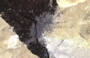
Cairo, the capital of Egypt, can be seen in these two Landsat images.
Twenty years separate these two Landsat thematic mapper images of Cairo, Egypt. Cairo is the capital city of Egypt and the largest city in both Africa and the Middle East. It is currently the thirteenth most populous city in the world. The 20th century saw a massive growth in the size of the city as peasants left the farmlands in pursuit of work in the factories and commerce of the metropolis. This is particularly evident by comparing the two images: the Eastern and Western suburbs grew considerably in 20 years, expanding far outside the fertile and dark sectors running along the river banks and occupying the deserted areas which surround the city. The official name of the city is al-Qâhirah, which means The Subdued. This name was given to the city as many armies were destroyed in the attempt to invade it or defeated elsewhere by troops sent from Cairo. Cairo lies on the banks and islands of the Nile River, immediately south of the point where the river leaves its desert-bound valley and breaks into the Nile Delta. The oldest part of the city grew along the east side the river and gradually spread west, engulfing the agricultural lands next to the Nile. These areas of the city were built on the model of Paris by Ismail the Magnificent in the mid-19th century and are characterised by wide boulevards, public gardens, and open spaces. By contrast, the older eastern section of the city is filled with small lanes and crowded tenements, having grown up haphazardly over the centuries. While western Cairo is dominated by the government buildings and modern architecture, the landmarks of the eastern city are hundreds of ancient mosques. Extensive water systems were implemented to allow the city to expand east into the desert. Bridges link the Nile islands of Gezira and Roda, and others cross the Nile attaching the city to the suburbs of Giza and Imbabah. The western sector of Giza, in the desert, is part of the ancient necropolis of Memphis, with its three large pyramids, including the Great Pyramid of Giza, the last surviving of the Seven Ancient Wonders of the World. The first Landsat-5 image was acquired on 23 June 1984 – Numerous wars with Israel forced thousands of refugees to flood the city. Between 1967 and 1978, much of the population of Sinai Peninsula and Suez Canal left for Cairo. The second Landsat-5 image was acquired on 2 April 2004 - – In 1987, the red line of the Cairo Metro opened after joining two existing above-ground lines with a large underground section through the city centre. The line runs for a total of 27 miles over ground of which 1.8 miles travels underground, serving 33 stations and carries passenger capacity of 60,000 in each direction. The metro runs from Helwan to the south of El-Marg down-town.
|
||||||||||||||||||||||


