|
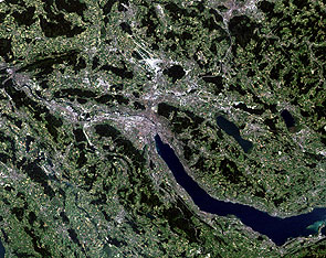
Zurich, Switzerland (1985-2004)
Nineteen years separate these two Landsat thematic mapper images of Zurich, the largest city in Switzerland. The two images were acquired on 3 July 1985 and 9 September 2004, respectively, by the Landsat Thematic Mapper (TM), the multispectral scanning radiometer on board Landsat 4 and 5. Zurich, once a Roman customs post by the name of Turicum, is situated at the northern end of Lake Zürich (Zürichsee), with the city centre split by the Limmat River and is surrounded by wooded hills. The river Sihl meets with the Limmat at the end of Platzspitz. Zurich experienced its greatest development phase between 1970 and 1990 with the construction of the highway network (until 1980) and the establishment of the high capacity short range railway system when it developed from a city to an urban region. Since 1985, the city's government has implemented concrete measures to make the city development more sustainable, and to improve the quality of life in the city centre. These efforts have been very successful and contributed a great deal to the current reputation of Zurich as a highly efficient city with an excellent quality of life. You can see Lake Zurich as the dark area to the bottom centre of both of the images with the Limmat running through the centre. The large white area to the north of the city is Zurich International Airport, the country's largest airport. The Lake of Lucerne (Vierwaldstaettersee) can be seen in the lower left corner. The upper part of the image shows the gentle hilly terrain while the image bottom is already part of the pre-alpine mountain chains. The first Landsat-5 image was acquired on 03 July 1985 – This is a Landsat thematic mapper image of Zurich, the largest city in Switzerland, in 1985. Zurich, once a Roman customs post by the name of Turicum, is situated at the northern end of Lake Zürich (Zürichsee), with the city centre split by the Limmat River and is surrounded by wooded hills. The river Sihl meets with the Limmat at the end of Platzspitz. Since 1985, the city's government has implemented concrete measures to make the city development more sustainable, and to improve the quality of life in the city centre. These efforts have been very successful and contributed a great deal to the current reputation of Zurich as a highly efficient city with an excellent quality of life. Venice is also served by the Marco Polo International Airport, or Aeroporto di Venezia Marco Polo, named in honour of its famous citizen. The airport is on the mainland and was rebuilt away from the coast. The second Landsat-5 image was acquired on 09 September 2004 – This is a Landsat thematic mapper image of Zurich, the largest city in Switzerland, in 2004. The Street Parade is a technoparade in Zurich. Its route leads along Lake Zurich. The Street Parade is as of 2004 one of the largest techno parties in the world and the largest annual event in Zurich. Zurich experienced its greatest development phase between 1970 and 1990. The city's government has implemented concrete measures to make the city development more sustainable, and to improve the quality of life in the city centre. These efforts have been very successful and contributed a great deal to the current reputation of Zurich as a highly efficient city with an excellent quality of life.
|
||||||||||||||||||||||


