- All Categories (29)
- Data (1)
- News (21)
- Missions (1)
- Events (1)
- Tools (1)
- Documents (4)
NEWS
Discover the latest news on the European Space Agency's Earth Observation activities. Learn all about new data availability and how ESA's missions are performing.
News - Thematic area articles
7 Dec 2023How to use space data to probe humankind’s ancient past
Data disseminated by ESA’s Third Party Missions (TPM) programme are enabling archaeological investigations that could help to unravel the mysteries of past societies and cultures.
News - Data Release news
21 Nov 2023The OneAtlas Data Download is now available for Pléiades Neo
In the framework of the Earthnet’s Third Party Missions programme, ESA announces that now Pléiades NEO data is also available through the OneAtlas Data Download subscription option, together with the already offered SPOT 6/7 and Pléiades data.
News - Thematic area articles
29 Aug 2023Tracking the world’s forests from space
As human activities continue to threaten the planet’s forests, data delivered by satellites are boosting global efforts to conserve these crucial natural resources.
News - Success Stories
17 Aug 2023Commercial and international data for fire monitoring
As climate change sparks a surge in the frequency and intensity of wildfires, satellite data disseminated through ESA’s Third Party Missions (TPM) programme are helping scientists to track and investigate these potentially damaging natural events.
News - Infographics
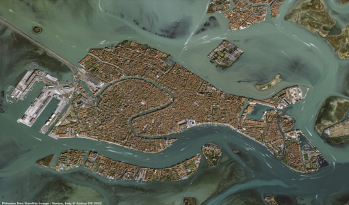
31 May 2023An overview of the Pléiades Neo mission
Pléiades Neo is a constellation of two very high-resolution satellites, launched in 2021, which were created to follow on from the Pléiades mission.
News - Thematic area articles
25 May 2023How satellite data empower sustainable urban growth
Earth observation is a vital tool for facilitating the sustainable development of the world's cities, helping to ensure that urban centres keep spurring collaboration, innovation and opportunity as they continue to expand.
News - Thematic area articles
3 Mar 2023Monitoring water on Earth's surface
ESA's Earth observation satellites are playing a leading role in furthering our understanding of how Earth's terrestrial hydrosphere is being influenced by humankind.
News - General News
16 Feb 2023International collaboration: Summarising ESA’s Third Party Missions
ESA’s Third Party Missions programme consists of more than 50 missions from around the world. Learn more about the Third Party Missions in this video.
News - Thematic area articles
9 Dec 2022Global understanding of Earth's land surfaces greatly boosted by satellite data
ESA perform land surface monitoring with a range of instruments onboard satellites acquiring optical and radar data. Collections of data from these missions are freely available for research purposes.
News - Thematic area articles
 29 Sept 2022
How satellite data help to shape society
Data from ESA’s Earth observation archives are improving understanding of the interactions between human activities and the environment, helping to power green economic development and boosting prosperity in Europe and beyond.
News - Thematic area articles
 16 Aug 2022
Satellites reveal changes to Earth’s icy zones
ESA’s Earth observation activities are helping scientists investigate the influence of climate change on widespread ice-losses across the planet.
News - Thematic area articles
 21 July 2022
Space helps monitor Earth’s changing biosphere
Earth’s biosphere is continually changing. Through its pioneering Earth observation missions, ESA is making critical contributions to monitor these changes and their impacts on Earth’s water and carbon cycles.
News - Success Stories
 27 June 2022
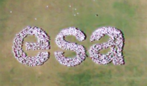
Pléiades Neo captures ESA Team Day event
At the European Space Research and Technology Centre (ESTEC), about 2000 staff created a human formation of the ESA logo and it was captured by Pléiades Neo high resolution optical satellite.
News - Events and Proceedings
 13 June 2022
Highlights from Living Planet Symposium
As remote sensing scientists and data-users from around the world converged at the Living Planet Symposium (LPS) in Bonn recently, a common thread was evident in many scientific sessions and meetings – the right environmental data can accelerate our understanding of the rapid changes in Earth’s system.
News - Data Release news
 30 May 2022
Pléiades Neo data now open to users
Very High Resolution optical Pléiades Neo data is available for research and development projects upon submission of a project proposal, subject to evaluation and acceptance by ESA and the data owner.
News - Success Stories
 23 May 2022
Living Planet Symposium showcases Pléiades Neo data
This week, the community of Earth observation data users gather at the Living Planet Symposium to explore the latest progress in Earth observation satellites and data.
News - Thematic area articles
 31 Mar 2022
Satellite data central to ocean monitoring
Over 95% of Earth’s water is found in our oceans, and yet sadly, oceans are under stress from climate change and pollution. Monitoring our oceans is vital for Earth’s survival and satellites are the primary means of long-term and independent observation of our vast ocean bodies and their associated coastal zones.
News - Success Stories
 17 Mar 2022
New open-source Python library improves rapid mapping services
In emergency services, rapid response is paramount. ICube-SERTIT’s Rapid Mapping Service provides near real-time delivery of geo-information to help emergency services respond quickly to disasters such as flooding, fires and landslides. A new Python open-source library, called EOReader, speeds up this mapping response by enabling the easy opening of imagery from multiple satellite sensors, both optical and synthetic aperture radar (SAR).
News - Thematic area articles
 2 Mar 2022
How space data are transforming the global food system
European Earth observation activities are accelerating a data-driven transformation in the agriculture sector that is helping farmers adapt to the dual challenges of climate change and population increase.
News - Thematic area articles
 2 Feb 2022
Satellite data boost global understanding of land surface
Understanding our changing land surface is essential in the study of climate change. Satellites are used to monitor changes to the material that covers Earth’s surface, so-called land cover, such as vegetation and water.