- Data
- WorldView-2 European Cities
WorldView-2 European Cities
Navigate To
How to Access Data
Project Proposal (Restrained)
- Go to the ESA User Services Portal
- Register or log in to EO Sign In
- After logging in, complete and submit the form with your proposed use of the data
- The proposal will be evaluated by ESA, which normally takes between 4 and 6 weeks
- Upon successful evaluation, you will receive a confirmation email, which describes the amount of data to be provided, and details of how to order the data
All WorldView products are freely accessible in accordance with ESA’s Earth observation data policy to users located in ESA Member States and ESA Cooperating/Associate States. An active EO Sign In account is required to download the products.
In ESA's Third Party Missions (TPM) dissemination service and catalogue the data is collection based and allows data browse and download through the treeview as well as via geographical search using a static map.
WorldView products can also be discovered through ESA's EO Catalogue (EO CAT), which allows users to discover and download products among the available datasets from ESA and Third Party Missions and instruments, using various criteria (spatial, temporal, specific).
For further information about the EO Sign In Service you can visit TellUs.
Should you need support to access the data, please contact EOHelp.
Available to Residents of the Following Countries
Collection Description
ESA, in collaboration with European Space Imaging, has collected this WorldView-2 dataset covering the most populated areas in Europe at 40 cm resolution. The products have been acquired between July 2010 and July 2015.
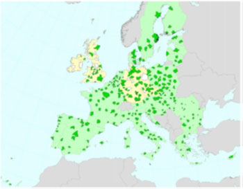
Spatial coverage: Check the spatial coverage of the collection on a map available on the Third Party Missions Dissemination Service.
Technical Details
DATA SET SPECIFICATIONS
PROCESSING LEVEL
APPLICABLE TERMS & CONDITIONS
Having Problems Accessing Data?
Resources
Discover Latest Data
2022 SEASTARex
The 2022 SEASTARex campaign over the Iroise Sea (offshore Brittany in France), is the first scientific demonstration and validation campaign...
IceSAR 2019
The ICESAR 2019 study was motivated by the need to improve the understanding of radar backscatter of sea ice at different wavelengths and po...
Airborne Quantum Gravimetry (AirQuantumGrav 2023)
The campaign collected data from airborne gravity campaigns AirQuantumGrav in Iceland and GreenQuantum in Greenland during summer 2023 using...
Announcement of Opportunity for Spire data
ESA is launching an Announcement of Opportunity for the international scientific community to access data from the Spire mission for science...