- All Categories (16)
- News (1)
- Missions (6)
- Tools (1)
- Documents (8)
Mission - Earth Explorers

GOCE
Explorer (GOCE) mission mapped Earth's geoid very accurately, opening a window into Earth's interior structure as well as the currents
Tools - Analysis

GOCE User Toolbox
Data output formats The current data formats that GUT can provide in output are: netCDF (Climate and Forecast Metadata Convention
Mission - Earth Explorers
GOCE Objectives
Thanks to this current, the coastal waters of Europe are 4°C warmer than waters at equivalent latitudes in the north Pacific
News - Data Release news

GOCE EGG L1b reprocessed data published
The GOCE L2 data, including the gravity field models, are currently being regenerated and will be available in Q2 2019.
Mission - Earth Explorers
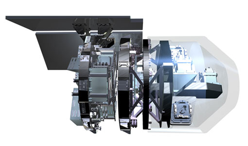
EGG
This opened a window into Earth's interior structure, as well as the currents circulating within the depths of its oceans
Document - Proceedings

EO-Summer-School-6-ESA-explorer-mission-GOCE-earth-gravity-from-space.pdf
This presentation from ESA's EO Summer School 6 presents the ESA explorer mission GOCE earth gravity from space
Mission - Earth Explorers
SSTI ANTEX Data
data were generated from 154 days in 2009 GOCE SSTI-B PCVs data were generated from the available data in 2010-2012 The current
Mission - Heritage Missions
GOCE re-entry dataset
with further dynamical and environmental information such as on-board magnetometer measurements of Earth's magnetic field, currents
Mission - Earth Explorers
GOCE Overview
height mapped by altimeters and the knowledge of the precise ocean geoid that has improved our understanding of surface currents
Document - General Reference

An-oceanographers-guide-to-GOCE-and-the-geoid.pdf
This article was published in Ocean Science Discussions. It gives a review of the geodetic concepts necessary for oceanographers to make use of satellite gravity data to define the geoid, and to interpret the resulting product.
Document - General Reference
ESA-Achievements-More-than-thirty-years-of-pioneering-space-activity.pdf
This volume gives a general overview of ESA's activities and programmes by analyzing the single missions where it is involved.
Document - Quality Report

GOCE EGG Monthly Report 01 Jul 2011
Figure 1 Current trace PSD (right), compared with previous days (left).
Document - Quality Report
GOCE EGG Monthly Report 01 Sep 2012
Figure 5 Current CM PSDs (right) and during the previous reference period (left) 3.4 Instrument calibration Special Spacecraft